
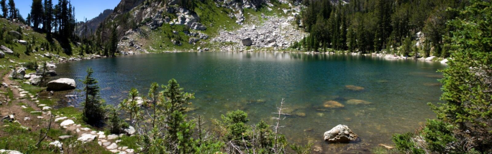

Ready to explore Mount Doane, Wyoming? Here's everything you need to know before you go!
Discover the trail

Trail description
Mount Doane (also known as First Peoples Mountain, Cairn Peak, and Doane Peak) is located in the Absaroka Range within Yellowstone National Park, standing as one of the more striking summits in the greater Yellowstone and Grand Teton region. Named after Lieutenant Gustavus Cheyney Doane, who led a military escort during the 1870 Washburn-Langford-Doane Expedition — one of the first organized explorations of the Yellowstone plateau — this peak carries real historical weight alongside its natural appeal. It's not just a mountain; it's a landmark tied directly to the story of how Yellowstone came to be recognized as a place worth protecting.
The mountain sits near the shores of Yellowstone Lake, one of the largest high-elevation lakes in North America, and the surrounding landscape reflects everything that makes this corner of Wyoming so distinct. You're in the heart of one of the most intact temperate ecosystems on the continent, where the terrain shifts between dense lodgepole pine forest, open subalpine meadows, and rocky ridgelines that open up to sweeping views of the lake and the Absaroka Range beyond.
The Terrain and What to Expect
Reaching the summit of Mount Doane is a serious undertaking. The approach involves navigating backcountry terrain that is remote by Yellowstone standards — and Yellowstone's backcountry is already a step above most places in terms of isolation and self-sufficiency requirements. The primary routes involve significant elevation gain through forested slopes before breaking out into more exposed alpine terrain near the top. The northeast ridge route entails approximately 5.0 miles of off-trail travel with about 3,000 feet of elevation gain, while the northwest ridge route is just over 4.5 miles with 3,300 feet of elevation gain. The upper mountain involves scrambling over loose rock and requires solid route-finding skills, especially in variable weather conditions.
This is not a maintained trail in the traditional sense. Hikers and climbers heading for the summit should be comfortable with off-trail travel, have experience reading topographic maps, and be prepared for rapidly changing mountain weather. Afternoon thunderstorms are a real and consistent hazard in this part of Wyoming during summer months, and the exposed upper ridges offer no shelter.
The views from the summit reward the effort in a way that few places in the region can match. Yellowstone Lake spreads out below in full, its surface reflecting the sky across an expanse that feels almost oceanic at this elevation. On clear days, the Tetons are visible to the south, and the volcanic plateau that defines so much of Yellowstone's character stretches out in every direction.
Wildlife and Ecosystem
The area around Mount Doane sits within one of the most wildlife-rich zones in Yellowstone. Grizzly bears are active throughout this part of the park, and any backcountry travel here requires carrying bear spray and knowing how to use it. Black bears, wolves, elk, and bison are all part of the landscape. Moose are frequently spotted near the marshy areas and stream drainages at lower elevations on the approach.
The forests in this zone are predominantly lodgepole pine, with Engelmann spruce and subalpine fir appearing at higher elevations. The transition from closed forest to open subalpine terrain happens gradually as you gain elevation, and the meadows along the way can be spectacular when wildflowers are in bloom during mid-summer.
Birdlife is diverse throughout the area. Osprey and bald eagles are commonly seen over Yellowstone Lake, and Clark's nutcrackers are a reliable presence in the upper subalpine zones. The lake itself supports a healthy population of native cutthroat trout, which in turn supports much of the larger wildlife in the ecosystem.
Access and Permits
Yellowstone National Park charges an entrance fee, and all overnight backcountry trips within the park require a backcountry permit. These permits are available through the National Park Service and should be secured well in advance, particularly for summer travel when demand is high. Day use does not require a separate permit beyond park entry.
The nearest developed area is the Lake Village and Bridge Bay area on the north shore of Yellowstone Lake, which provides the closest services including a visitor center, lodging, and a marina. Road access into this part of the park is seasonal, with most routes opening in late spring and closing in fall depending on snowpack and conditions.
Dogs are not permitted on backcountry trails within Yellowstone National Park. This is a firm park-wide policy, not a suggestion, and it applies to the approaches toward Mount Doane as it does everywhere else in the park's backcountry.
Planning Considerations
The window for attempting Mount Doane is relatively narrow. Snow can linger on the upper mountain well into July, and early fall storms can bring new accumulation by September. The most reliable conditions typically fall in a window from mid-July through late August, though this varies year to year.
Water sources are available along the lower portions of the approach, but all water in the backcountry should be treated before drinking. Carrying a filter or chemical treatment is standard practice here.
Cell service is essentially nonexistent in this part of Yellowstone. Filing a trip plan with someone reliable before heading out is a basic safety step that experienced backcountry travelers treat as non-negotiable in terrain this remote. A personal locator beacon or satellite communicator is worth serious consideration for any summit attempt on Mount Doane.
Historical Context
The name itself is a reminder of how recently this landscape entered the public consciousness. The 1870 Washburn Expedition, which Doane helped escort and documented in a detailed report to the U.S. Army, played a direct role in building the case for Yellowstone's establishment as the world's first national park in 1872. Standing on the summit that bears his name, with Yellowstone Lake below and the plateau stretching in every direction, connects the physical experience of the mountain to that larger story in a way that feels genuinely meaningful rather than just historical trivia.
Mount Doane is the kind of objective that asks something real of the people who attempt it — in preparation, fitness, and judgment — and gives back a perspective on the Yellowstone landscape that very few visitors ever get to experience firsthand.
The Essential Hiking Checklist
Everything you need for your next hike. Bilingual, printable, 1 page.
Get your free hiking checklistRecommended gear for this trail
As an Amazon Associate I earn from qualifying purchases.


Ready to go?
Everything you need to know before you goWhen?
How much?
As an Amazon Associate I earn from qualifying purchases.
Affiliate links — LGPO may earn a commission at no extra cost to you.
- Hiking shoes Essential
- → Salomon Elixir Tour Mid WP · 203.38 $
- Layered clothing Essential
- Rain jacket Essential
- Trekking poles
- → Black Diamond Trail Ergo Cork · 69.99 $
- Headlamp
- → Petzl Actik Core 625 · 103.95 $
FAQ - Frequently asked questions
Everything you need to knowSimilar hikes nearby
Discover other trails you might enjoy
Heart Mountain, Wyoming
Yellowstone & Grand Teton
Pollux Peak, Wyoming
Yellowstone & Grand Teton
Signal Mountain, Wyoming
Yellowstone & Grand Teton

Cache Mountain, Wyoming
Yellowstone & Grand Teton

Mount Langford, Wyoming
Yellowstone & Grand Teton
Grand Teton, Wyoming
Yellowstone & Grand Teton
Hiking near Regina
4 trails to explore ~789 km away
We work hard to provide the most up-to-date and error-free data possible. If something seems incorrect, let us know! Your contribution helps the whole community.
Hikers' opinions
Be the first to review!
No hiker has shared their experience yet. Share your impressions and help other hikers!