
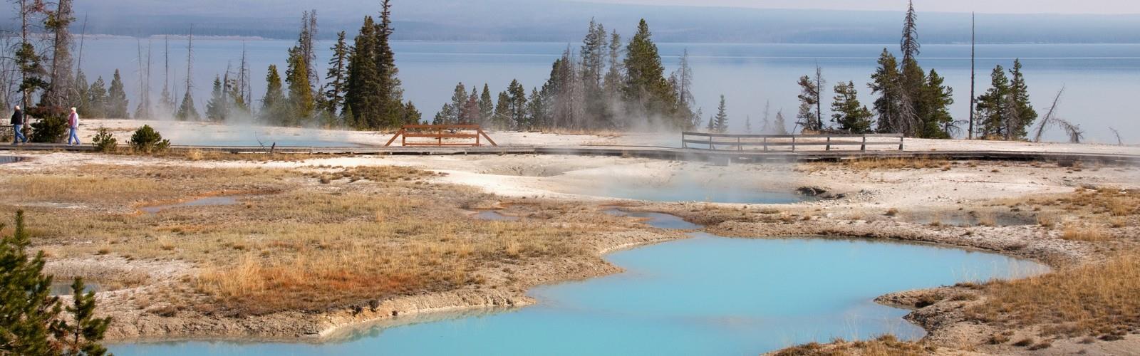

Ready to explore West Thumb Geyser Basin? Here's everything you need to know before you go!
Discover the trail
Oh no! We don't have any photos 😢
This trail hasn't been captured yet. Be the first to share your adventure!Trail description
The geothermal areas of Yellowstone include several geyser basins in Yellowstone National Park as well as other geothermal features such as hot springs, mud pots, and fumaroles. The number of thermal features in Yellowstone is estimated at 10,000. A study that was completed in 2011 found that a total of 1283 geysers have erupted in Yellowstone, 465 of which are active during an average year. These are distributed among nine geyser basins, with a few geysers found in smaller thermal areas throughout the Park. The number of geysers in each geyser basin are as follows: Upper Geyser Basin (410), Midway Geyser Basin (59), Lower Geyser Basin (283), Norris Geyser Basin (193), West Thumb Geyser Basin (84), Gibbon Geyser Basin (24), Lone Star Geyser Basin (21), Shoshone Geyser Basin (107), Heart Lake Geyser Basin (69), other areas (33). Although famous large geysers like Old Faithful are part of the total, most of Yellowstone's geysers are small, erupting to only a foot or two. The hydrothermal system that supplies the geysers with hot water sits within an ancient active caldera. Many of the thermal features in Yellowstone build up sinter, geyserite, or travertine deposits around and within them.
The various geyser basins are located where rainwater and snowmelt can percolate into the ground, get indirectly superheated by the underlying Yellowstone hotspot, and then erupt at the surface as geysers, hot springs, and fumaroles. Thus flat-bottomed valleys between ancient lava flows and glacial moraines are where most of the large geothermal areas are located. Smaller geothermal areas can be found where fault lines reach the surface, in places along the circular fracture zone around the caldera, and at the base of slopes that collect excess groundwater. Due to the Yellowstone Plateau's high elevation the average boiling temperature at Yellowstone's geyser basins is 199 °F (93 °C). When properly confined and close to the surface it can periodically release some of the built-up pressure in eruptions of hot water and steam that can reach up to 390 feet (120 m) into the air (see Steamboat Geyser, the world’s tallest geyser). Water erupting from Yellowstone's geysers is superheated above that boiling point to an average of 204 °F (95.5 °C) as it leaves the vent. The water cools significantly while airborne and is no longer scalding hot by the time it strikes the ground, nearby boardwalks, or even spectators. Because of the high temperatures of the water in the features it is important that spectators remain on the boardwalks and designated trails. Several deaths have occurred in the park as a result of falls into hot springs.
Prehistoric Native American artifacts have been found at Mammoth Hot Springs and other geothermal areas in Yellowstone. Some accounts state that the early people used hot water from the geothermal features for bathing and cooking. In the 19th century Father Pierre-Jean De Smet reported that natives he interviewed thought that geyser eruptions were "the result of combat between the infernal spirits." The Lewis and Clark Expedition traveled north of the Yellowstone area in 1806. Local natives that they came upon seldom dared to enter what we now know is the caldera because of frequent loud noises that sounded like thunder and the belief that the spirits that possessed the area did not like human intrusion into their realm. The first whiteman known to travel into the caldera and see the geothermal features was John Colter, who had left the Lewis and Clark Expedition. He described what he saw as "hot spring brimstone." Beaver trapper Joseph Meek recounted in 1830 that the steam rising from the various geyser basins reminded him of smoke coming from industrial smokestacks on a cold winter morning in Pittsburgh, Pennsylvania. In the 1850s famed trapper Jim Bridger called it "the place where Hell bubbled up."
Free
1 pages
The Essential Hiking Checklist
Everything you need for your next hike. Bilingual, printable, 1 page.
Get your free hiking checklistRecommended gear for this trail
As an Amazon Associate I earn from qualifying purchases.
LGPO Pick

Salomon
Elixir Tour Mid WP
Waterproof mid-height boot ideal for rocky terrain
203.38 $


Affiliate links — LGPO may earn a commission at no extra cost to you.
Ready to go?
Everything you need to know before you goWhen?
Opening hours
No information
Varies by season
Best season
Fall
Spectacular colors
Best time
Early morning
Less crowded
Weather (next days)
Loading
How much?
Entry fees
Adult
Not available
Child
—
What to bring?
As an Amazon Associate I earn from qualifying purchases.
Affiliate links — LGPO may earn a commission at no extra cost to you.
Gear
- Hiking shoes Essential
- → Salomon Elixir Tour Mid WP · 203.38 $
- Layered clothing Essential
- Rain jacket Essential
- Trekking poles
- → Black Diamond Trail Ergo Cork · 69.99 $
- Headlamp
- → Petzl Actik Core 625 · 103.95 $
Water & food
2L minimum
No water point on the trail
Bring energy snacks for a 4h+ hike
Good to know
Park rules
No dogs
Safety
Download the GPX before you go
Limited cellular coverage on the trail
Slippery after rain
Be careful on rocky sections
In an emergency
Emergency
911
Parking GPS
44.4157, -110.5719683
Center
Not available
FAQ - Frequently asked questions
Everything you need to knowWest Thumb Geyser Basin is rated moderate.
The elevation gain of West Thumb Geyser Basin is 304 m.
The summit of West Thumb Geyser Basin is at 2,895 m.
Allow about 2h50 for West Thumb Geyser Basin (10 km).
No, dogs are not allowed on the trails of West Thumb Geyser Basin.
No, West Thumb Geyser Basin has no visitor centre on site.
Didn't find your answer?
Similar hikes nearby
Discover other trails you might enjoy
Heart Mountain, Wyoming
Yellowstone & Grand Teton
16.1 KM
4h15
106 M
Beginner
Pollux Peak, Wyoming
Yellowstone & Grand Teton
3.7 KM
50 min
30 M
Beginner

Mount Doane, Wyoming
Yellowstone & Grand Teton
4.8 KM
1h12
100 M
Beginner
Signal Mountain, Wyoming
Yellowstone & Grand Teton
6.1 KM
1h10
6 M
Beginner

Cache Mountain, Wyoming
Yellowstone & Grand Teton
3.4 KM
40 min
610 m
Beginner

Mount Langford, Wyoming
Yellowstone & Grand Teton
14.5 KM
4h30
167 M
Intermediate
Top 10 best hiking in Yellowstone & Grand Teton
Our ranking based on hiker reviews
Hiking near Calgary
120 trails to explore ~782 km away
Did you spot an error?
We work hard to provide the most up-to-date and error-free data possible. If something seems incorrect, let us know! Your contribution helps the whole community.
Hikers' opinions
Be the first to review!
No hiker has shared their experience yet. Share your impressions and help other hikers!