

Ready to explore Dry Gulch Provincial Park? Here's everything you need to know before you go!
Discover the trail
Trail description
Description
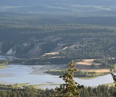
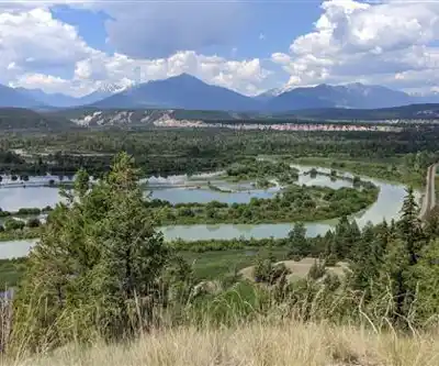
Dry Gulch Provincial Park sits quietly in the Kootenay Rockies near Radium Hot Springs, offering a genuinely low-key alternative to the region's busier destinations. The park punches above its weight in terms of variety — you move through dense forest sections, open meadows, and rocky terrain within a relatively compact area, all while the Columbia Valley stretches out below you. It's close enough to Radium Hot Springs for a casual day trip, but the moment you step onto the trail, the crowds feel far away.
The Hiking Experience
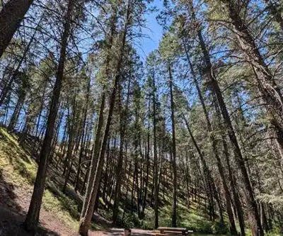
The trail network here is straightforward without being boring. Paths wind through mixed forest dominated by Douglas fir and lodgepole pine, where the canopy keeps things cool and the ground underfoot stays soft. These lower sections have a pleasant, enclosed feel — the kind of walking where you're focused on what's immediately around you rather than scanning for distant views.
That changes as you gain elevation. The forest gradually opens into meadow terrain, the sky widens, and the surrounding peaks of the Kootenay Rockies come into full view. The shift from shaded forest to open alpine meadow is one of the more satisfying transitions this park offers, and it happens naturally rather than abruptly.
The 200-meter elevation gain is spread out enough that it never feels punishing. The easy difficulty rating holds up — this is a trail where you can actually look around and take things in rather than keeping your eyes fixed on the ground. The estimated hour and twenty minutes is a reasonable target, though most people find themselves slowing down in the meadow sections where the views invite you to stop.
Trail conditions are generally well-maintained, and the routes are marked clearly enough that you won't second-guess yourself, but not so heavily signed that it feels like a theme park. That balance is part of what gives Dry Gulch its backcountry character despite being accessible to casual hikers.
Wildlife and Natural Features
The park's mix of forest and open meadow creates good habitat diversity, and wildlife sightings are a regular part of the experience here. Deer move through both zones, most often spotted during early morning or evening hours. Elk show up in the larger clearings, particularly on quieter weekday visits when human traffic is lower. The bird life covers both forest and meadow species — woodpeckers and nuthatches in the trees, mountain bluebirds and various raptors once you reach the open sections.
Black bears are present in the area, so standard precautions apply. Make noise on the trail, especially through dense vegetation or around blind corners, and carry bear spray. The wildlife here tends to be relatively undisturbed, which makes for good observation opportunities if you're patient and move quietly between noise-making intervals.
The meadow sections produce solid wildflower displays, with lupines, paintbrush, and mountain asters appearing along trail edges. Early summer tends to be the peak for blooms, while the forest sections stay green and cool well into the warmer months.
Picnic Areas and Day Use
The park's picnic facilities are positioned to take advantage of natural clearings and mountain views rather than just being dropped wherever was convenient. The tables sit in spots that work well for a mid-hike break or a post-trail meal, with enough space for families or small groups without feeling like a parking lot. Several of the elevated picnic areas double as solid viewpoints, making them worth a stop even if you're not eating.
The picnic sites connect directly to the main trail network, so you can move easily between hiking and taking a break without backtracking to a separate area.
Camping
Overnight camping at Dry Gulch lets you experience the park at its quietest. Campsites are set into the forest in a way that provides reasonable privacy, and the access road works fine for regular vehicles and smaller RVs, though it's not suited to large rigs. Evenings bring noticeably cooler temperatures even in summer, so layers are worth packing regardless of how warm the afternoon felt.
Morning is the best time to be on the trail from the campground — wildlife is more active, the light on the surrounding peaks is excellent for photography, and you'll often have the paths to yourself for the first hour or two after sunrise.
Getting There and Planning Your Visit
The park's location near Radium Hot Springs makes it easy to reach by regular vehicle, and the access road is manageable without any special clearance or four-wheel drive in normal conditions. Winter access depends on snow and road maintenance, and spring visits may involve muddy trail sections as snowmelt works through the system.
Parking handles typical visitor loads without issue, though summer weekends can fill available spaces earlier in the day. Arriving by mid-morning generally keeps your options open. Bring enough water for the full hike — the elevation and dry mountain air increase dehydration faster than lower-elevation trails might suggest. Cell coverage is inconsistent throughout the park, with some areas getting a signal and others going dark, so plan accordingly and don't rely on your phone for navigation.
Recommended gear for this trail


Ready to go?
Everything you need to know before you goStarting Point
The easiest way to get to the start of the trails at the dry gulch provincial park is to drive north on Highway 97 from Vernon until you reach the junction for Highway 6. Turn left onto Highway 6 and drive until you reach the park entrance, which is located about 9 km from the junction.
When?
How much?
- Hiking shoes Essential
- → Salomon Elixir Tour Mid WP · 203.38 $
- Layered clothing Essential
- Rain jacket Essential
- Trekking poles
- → Black Diamond Trail Ergo Cork · 69.99 $
- Headlamp
- → Petzl Actik Core 625 · 103.95 $
FAQ - Frequently asked questions
Everything you need to knowThe Essential Hiking Checklist
Everything you need for your next hike. Bilingual, printable, 1 page.
Download the free checklistSimilar hikes nearby
Discover other trails you might enjoy

Emerald Lake
Kootenay Rockies

Golden Skybridge
Kootenay Rockies

Mount Stephen
Kootenay Rockies
Bugaboo Provincial Park
Kootenay Rockies
Magog, Lake
Kootenay Rockies
Iceline Trail
Kootenay Rockies
Hiking near Banff
187 trails to explore ~74 km away
We work hard to provide the most up-to-date and error-free data possible. If something seems incorrect, let us know! Your contribution helps the whole community.
Hikers' opinions
Be the first to review!
No hiker has shared their experience yet. Share your impressions and help other hikers!