


Ready to explore Floe Lake? Here's everything you need to know before you go!
Discover the trail
Trail description
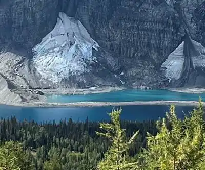
Floe Lake sits deep in Kootenay National Park, offering one of the most dramatic alpine settings in the Canadian Rockies. This pristine mountain lake reflects the towering limestone walls of the Rockwall, creating a scene that stops hikers in their tracks. The 21.4-kilometer round-trip trail demands commitment—expect 7.5 hours of hiking with 997 meters of elevation gain—but delivers an experience that ranks among British Columbia's finest backcountry destinations.
The trail begins near Marble Canyon, immediately immersing you in the dense montane forests that characterize this region. These lower elevations provide habitat for deer, marmots, and black bears, making bear spray essential gear. The initial kilometers wind through thick stands of spruce and fir, with the trail gradually climbing as it follows ancient creek beds and crosses several small tributaries.
The Trail Experience
The first major landmark comes early—a dramatic suspension bridge spanning the Kootenay River. This engineering marvel provides both a memorable crossing and excellent photo opportunities, with the rushing water below and mountain peaks framing the scene. Beyond the bridge, the trail begins its serious ascent through increasingly varied terrain.
As you climb higher, the dense forest gradually opens into subalpine meadows. During summer months, these clearings explode with wildflowers—Indian paintbrush, alpine forget-me-nots, and mountain avens create colorful carpets against the backdrop of gray limestone peaks. The contrast between the delicate blooms and the massive rock walls above captures the essence of Rocky Mountain hiking.
The trail's middle section presents the most challenging terrain. Switchbacks carved into steep slopes demand steady footing and regular rest stops. Here, cascading waterfalls tumble down from hidden cirques above, their mist providing welcome cooling on warm days. The sound of falling water becomes a constant companion as you work your way up through this dramatic landscape.
Massive rock walls begin to dominate the scenery as you approach treeline. These towering limestone cliffs, part of the famous Rockwall formation, rise nearly vertically from the valley floor. The scale becomes almost overwhelming—these ancient seafloor sediments, now thrust skyward, create some of the most impressive vertical relief in the Canadian Rockies.
Reaching the Lake
The final approach to Floe Lake reveals why this destination attracts hikers from around the world. The crystal-clear alpine waters stretch across a natural amphitheater, completely surrounded by the sheer walls of the Rockwall. This limestone barrier rises over 1,000 meters directly from the lake's edge, creating a sense of scale that photographs struggle to capture.
The lake itself sits at treeline, where scattered alpine larches and whitebark pines cling to rocky shores. These hardy survivors frame views across the water to the massive cliff face beyond. On calm days, the lake's surface creates perfect reflections of the towering walls, doubling the visual impact of this already stunning setting.
Several designated backcountry campsites occupy the lake's eastern shore, making overnight trips possible for those with proper permits. These sites offer front-row seats to one of the Rockies' most spectacular sunrise and sunset shows, as changing light transforms the limestone walls from gray to gold to deep orange.
Planning Your Visit
This trail demands serious preparation and respect for mountain conditions. Weather can change rapidly at this elevation, with snow possible even in summer months. Sturdy hiking boots with good ankle support are essential for the rocky, uneven terrain. Pack layers for temperature variations—the trailhead might be warm while the lake remains cool even on summer days.
Water sources exist along the route, but carrying sufficient supplies reduces the need for frequent stops and filtration. The exposed sections near the lake offer little shelter, making sun protection crucial during clear weather. Bear spray is mandatory in this wilderness area where both black bears and grizzlies roam.
The trail typically opens in late June or early July, depending on snowpack conditions. Peak wildflower season runs from mid-July through August, while September offers cooler temperatures and the golden display of alpine larch needles. Early season hikers may encounter snow patches and muddy conditions, particularly in the higher elevations near the lake.
Check current trail conditions and weather forecasts before departing, as afternoon thunderstorms are common in summer. The exposed terrain near the lake becomes dangerous during electrical storms, making early starts advisable. Most hikers begin before dawn to reach the lake by midday and return before afternoon weather develops.
Leave No Trace principles are especially important in this pristine environment. Pack out all waste, stay on designated trails, and camp only in established sites if staying overnight. The fragile alpine ecosystem around Floe Lake recovers slowly from damage, making careful foot placement and minimal impact camping essential for preserving this remarkable destination.
Recommended gear for this trail
As an Amazon Associate I earn from qualifying purchases.


Ready to go?
Everything you need to know before you goStarting Point
The floe lake trailhead is located in the Kootenay National Park, British Columbia. To get there, take Highway 93 south from Radium Hot Springs to the turnoff for Kootenay National Park (just past the town of Marble Canyon). Follow the signs to the park and then to floe lake. The drive from Radium Hot Springs to the floe lake trailhead takes about 2 hours.
When?
How much?
As an Amazon Associate I earn from qualifying purchases.
Affiliate links — LGPO may earn a commission at no extra cost to you.
- Hiking shoes Essential
- → Salomon Elixir Tour Mid WP · 203.38 $
- Layered clothing Essential
- Rain jacket Essential
- Trekking poles
- → Black Diamond Trail Ergo Cork · 69.99 $
- Headlamp
- → Petzl Actik Core 625 · 103.95 $
FAQ - Frequently asked questions
Everything you need to know
25 hikes under 2 hours from Montreal
Distance, elevation, parking and season for each one. The ones we go back to ourselves.
Get the guideSimilar hikes nearby
Discover other trails you might enjoy

Emerald Lake
Kootenay Rockies

Golden Skybridge
Kootenay Rockies
Mount Stephen
Kootenay Rockies
Magog, Lake
Kootenay Rockies
Iceline Trail
Kootenay Rockies
Valhalla Provincial Park
Kootenay Rockies
Hiking near Banff
187 trails to explore ~42 km away
We work hard to provide the most up-to-date and error-free data possible. If something seems incorrect, let us know! Your contribution helps the whole community.
Hikers' opinions
Be the first to review!
No hiker has shared their experience yet. Share your impressions and help other hikers!