

Ready to explore Kootenay National Park? Here's everything you need to know before you go!
Discover the trail
Trail description
Description
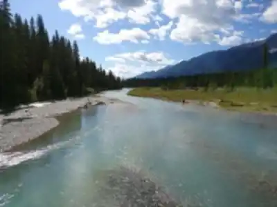
Kootenay National Park sits in the heart of the Kootenay Rockies in British Columbia, and it earns its place as one of the most varied hiking destinations in the Canadian Rockies. While Banff and Jasper tend to grab the headlines, Kootenay quietly delivers an experience that covers more ecological ground than most parks its size — from painted mineral springs and carved limestone canyons to high alpine escarpments and natural hot springs. The park's trail network spans over 200 kilometers of maintained paths, giving hikers a genuine range of options whether they're out for a short afternoon walk or a multi-day backcountry commitment.
Trail Network and Hiking Options
What makes Kootenay's trail system stand out is how quickly the landscape shifts. You're not locked into one type of terrain. Valley trails run through dense spruce and fir forest, mid-elevation routes open up into rocky subalpine zones, and the upper trails push into exposed alpine terrain where the scale of the surrounding peaks becomes fully apparent. That variety within a single park means a hiker can experience several distinct environments in one day without driving between trailheads.
The Stanley Glacier Trail is one of the park's most rewarding moderate hikes. The route moves through a broad valley flanked by towering peaks before opening up to a direct view of the glacier itself. The approach alternates between forested sections — where the canopy breaks the light into shifting patterns — and open terrain where the full amphitheater of surrounding rock comes into view. It's the kind of trail that builds well, with the payoff arriving gradually rather than all at once.
For hikers ready to commit to multiple days, the Rockwall Trail is one of the standout backcountry routes in the Canadian Rockies. The trail follows the base of a massive limestone escarpment, with cliffs rising sharply from the path and creating a sense of scale that's hard to find elsewhere. The route crosses mountain passes, moves through high alpine terrain, and puts you in camp locations where there's nothing between you and the night sky. It requires solid backcountry experience and proper preparation, but the wilderness solitude and the quality of the scenery make it worth the effort.
Geological Features Worth Stopping For
Kootenay's geology is one of its defining characteristics, and two features in particular are genuinely worth building your visit around.
The Paint Pots are unlike anything else in the Rockies. Iron-rich mineral springs bubble up from underground and deposit ochre sediments across the ground in vivid oranges, reds, and yellows. Set against the surrounding green forest, the color contrast is striking enough that it can feel almost out of place — in the best way. The walk to reach the Paint Pots is short and accessible, making it a reasonable stop for hikers of any level. The ochre deposits here were historically significant to Indigenous peoples, who used the pigment for paint and trade.
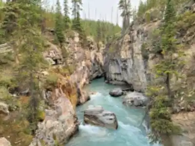
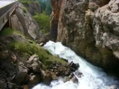
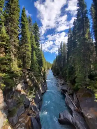
Marble Canyon offers a completely different kind of geological experience. Turquoise water has carved deep, narrow channels through limestone bedrock over thousands of years, and a series of bridges lets you cross back and forth over the canyon at different points. The rock walls reflect the light in ways that change depending on the time of day, and the sound of rushing water fills the gorge throughout. It's a short walk, but the visual impact is significant.
Wildlife
The park's range of elevation zones supports a broad mix of wildlife. Bighorn sheep are regularly spotted on rocky slopes and near mineral licks, where they descend to lower elevations — particularly during rutting season when rams are active and visible. Mountain goats tend to stay higher up, often visible as white shapes against dark cliff faces. With patience and binoculars, you can watch them navigate ledges that look impossibly narrow from below.
Kootenay also has an established grizzly bear population. Hikers should carry bear spray, make noise on the trail, and follow Parks Canada's bear safety guidelines. The presence of grizzlies is also a reminder of how intact the park's ecosystem remains — this is functioning wilderness, not a managed wildlife display.
The shift between valley forest and alpine meadow happens quickly at elevation, and each zone supports different species. Wildflowers push through the alpine meadows during the brief mountain summer, and the variety of plant communities along a single trail makes for consistently changing scenery throughout a day's hike.
Radium Hot Springs
Radium Hot Springs, located at the park's southern entrance, is a practical and genuinely enjoyable way to end a day on the trails. The mineral pools maintain comfortable temperatures year-round, and the setting — with mountain terrain rising directly around the pool area — means you're still in the landscape even while you're soaking. After a long day on a trail like the Rockwall, having a hot springs this close to the trailhead is a real advantage.
Access and Best Times to Visit
Highway 93 South runs through the park, connecting Banff National Park to the north with the town of Radium Hot Springs to the south. Trailheads and pullouts are distributed along the highway, making access straightforward for most destinations within the park. The road stays open year-round, though winter driving conditions and seasonal trail closures affect what's accessible depending on when you visit.
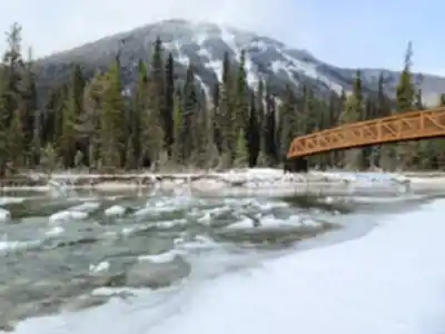
The most reliable window for hiking runs from late spring through early fall. Valley trails and lower-elevation routes typically open earlier in the season, while higher trails — including approaches to the Rockwall — may hold snow well into summer. Late spring brings active wildlife and early wildflower blooms. Early fall offers stable weather and noticeably fewer people on the trails. Checking current trail conditions through Parks Canada before heading out is always a good idea, especially for anything above the valley floor.
Recommended gear for this trail


Ready to go?
Everything you need to know before you goStarting Point
The start of the trails at the kootenay national park in British Columbia can be accessed from Highway 93.
When?
How much?
- Hiking shoes Essential
- → Salomon Elixir Tour Mid WP · 203.38 $
- Layered clothing Essential
- Rain jacket Essential
- Trekking poles
- → Black Diamond Trail Ergo Cork · 69.99 $
- Headlamp
- → Petzl Actik Core 625 · 103.95 $
FAQ - Frequently asked questions
Everything you need to knowThe Essential Hiking Checklist
Everything you need for your next hike. Bilingual, printable, 1 page.
Download the free checklistSimilar hikes nearby
Discover other trails you might enjoy

Emerald Lake
Kootenay Rockies

Golden Skybridge
Kootenay Rockies

Mount Stephen
Kootenay Rockies
Bugaboo Provincial Park
Kootenay Rockies
Magog, Lake
Kootenay Rockies
Iceline Trail
Kootenay Rockies
Hiking near Banff
187 trails to explore ~35 km away
We work hard to provide the most up-to-date and error-free data possible. If something seems incorrect, let us know! Your contribution helps the whole community.
Hikers' opinions