

Ready to explore Lake O'Hara? Here's everything you need to know before you go!
Discover the trail

Trail description
Description
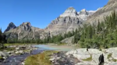
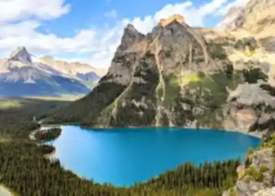
Lake O'Hara sits like a turquoise jewel in the alpine heart of Yoho National Park, surrounded by some of the most dramatic peaks in the Canadian Rockies. This isn't your typical roadside mountain lake — getting here requires advance planning and a genuine commitment to preserving one of British Columbia's most pristine wilderness areas. The reward is a hiking experience that feels worlds away from crowded tourist destinations, where crystalline waters reflect towering limestone cliffs and an extensive trail network leads through landscapes that seem almost too perfect to be real.
The area offers roughly 11 kilometers of interconnected trails with 500 meters of elevation gain spread across various routes, making for approximately 4 hours and 15 minutes of moderate hiking depending on which combination of paths you choose. But those numbers only tell part of the story. Lake O'Hara functions more as a hiking hub than a single destination, with trails radiating outward from the central lake to access hanging valleys, alpine passes, and viewpoints that showcase the raw beauty of the Continental Divide.
Trail Network and Terrain
The Lake O'Hara Shoreline Trail is the natural starting point for most visitors — a gentle loop that hugs the lake's perimeter and offers a full introduction to the area without demanding too much from your legs. The trail surface alternates between packed earth, wooden boardwalks over marshy sections, and occasional rocky stretches. It stays relatively flat as it winds through subalpine forest and opens onto rocky shoreline sections where you can pause to take in the full scope of the surrounding amphitheater of peaks. It's accessible for most fitness levels while still delivering a genuine wilderness feel.
For hikers ready to push further, the Alpine Circuit is the area's crown jewel. This more demanding route climbs steadily through increasingly dramatic terrain toward Wiwaxy Gap and Opabin Prospect. The ascent moves through distinct ecological zones — starting in dense forest before breaking into open alpine meadows during peak summer months. The final push to the viewpoints involves some scrambling over loose rock and requires sure footing, but the panoramic views from these elevated perches give you full perspective on the entire Lake O'Hara basin and the peaks that define this corner of the Rockies.
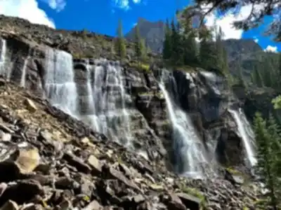
What sets Lake O'Hara apart from other mountain hiking destinations is the sheer density of high-quality trails packed into a compact area. Lush alpine meadows transition quickly into stark rock faces, while hidden tarns and cascading waterfalls appear around seemingly every corner. You might find yourself walking along a peaceful lakeshore one moment and picking your way across a boulder field the next — the terrain shifts dramatically even within short distances.
Access and Reservations
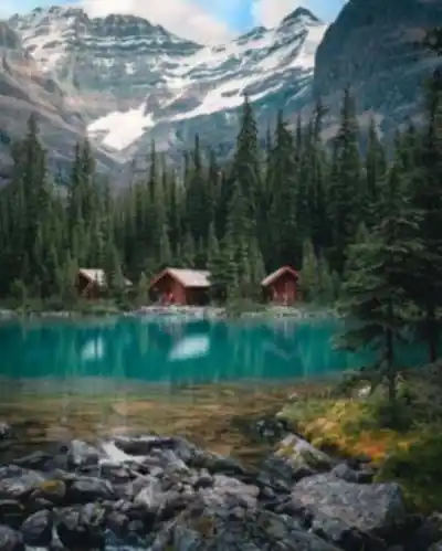
Lake O'Hara operates under a strict reservation system managed by Parks Canada, designed to limit daily visitor numbers and protect the area's delicate alpine ecosystem. Advance planning through Parks Canada's reservation system is absolutely essential — you cannot simply show up and hope for the best. The reservation requirement applies whether you're planning to stay at the nearby campground, the historic Lake O'Hara Lodge, or just coming for a day of hiking.
This controlled access creates an experience that feels increasingly rare in popular mountain destinations: uncrowded trails where you can hike for hours without encountering large groups, and pristine natural settings where wildlife sightings remain common and undisturbed. The trade-off is the need to plan well ahead and stay flexible with your dates, as reservations can be competitive during peak hiking season.
What Makes This Place Special
The magic of Lake O'Hara lies in its combination of accessibility and genuine wildness. The trail network is extensive and well-maintained, yet the controlled access means the area retains a backcountry feel that's becoming harder to find in the Canadian Rockies. The turquoise color of the water comes from glacial flour — finely ground rock particles suspended in the water that create an almost supernatural hue, one that shifts throughout the day as light conditions change.
The surrounding peaks form a natural amphitheater that concentrates the area's dramatic beauty into a relatively small space. Towering limestone cliffs rise directly from the lake's edges in places, while gentler slopes covered in alpine vegetation provide contrast and softer hiking terrain. This geological variety translates into a wide range of hiking experiences, from peaceful lakeside strolls to challenging scrambles that demand full attention and proper preparation.
Wildlife thrives in this protected environment. Mountain goats pick their way across the higher cliff faces, marmots pop up in the alpine meadows, and various bird species make their home in the diverse habitats around the lake. The limited human presence means animals tend to behave more naturally, though hikers should always maintain appropriate distances and follow Leave No Trace principles.
Photographers and nature enthusiasts have long considered Lake O'Hara one of the premier destinations in the Canadian Rockies for capturing alpine wilderness at its most striking. The interplay of water, rock, and sky creates compositions that shift dramatically with weather and season, while the controlled access ensures you won't be competing with crowds for a quiet moment or a clear view.
Practical Tips
- Book early: Reservations through Parks Canada fill up fast, especially for summer weekends. Check availability well in advance of your planned visit.
- Footwear matters: The mix of boardwalks, packed earth, and rocky scrambling sections means sturdy hiking boots with ankle support are strongly recommended over trail runners.
- Weather changes fast: At alpine elevation, conditions can shift quickly. Pack layers, a rain shell, and sun protection regardless of the forecast.
- Wildlife awareness: Carry bear spray and know how to use it. Stay on marked trails and give all wildlife plenty of space.
- Leave No Trace: The reservation system exists precisely because this ecosystem is fragile. Pack out everything you bring in and stick to established paths.
Whether you're drawn by the challenge of the Alpine Circuit's demanding terrain or prefer the contemplative pace of the Shoreline Trail, Lake O'Hara delivers a mountain experience that feels both intimate and grand — one of British Columbia's most carefully preserved wilderness areas, and one that rewards the effort it takes to get there.
Recommended gear for this trail


Ready to go?
Everything you need to know before you goStarting Point
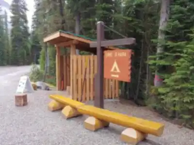
To access the hiking trails, you need to start at the lake o'hara parking lot. The parking lot is located along the Yoho Valley Road, which is off the Trans-Canada Highway (Highway 1). From there, a shuttle bus operated by Parks Canada takes visitors to the trailheads around lake o'hara. Note that reservations for the shuttle are required in advance. There are no alternative trailheads accessible by car; hiking into the area without using the shuttle is not permitted.
When?
How much?
- Hiking shoes Essential
- → Salomon Elixir Tour Mid WP · 203.38 $
- Layered clothing Essential
- Rain jacket Essential
- Trekking poles
- → Black Diamond Trail Ergo Cork · 69.99 $
- Headlamp
- → Petzl Actik Core 625 · 103.95 $
FAQ - Frequently asked questions
Everything you need to knowThe Essential Hiking Checklist
Everything you need for your next hike. Bilingual, printable, 1 page.
Download the free checklistSimilar hikes nearby
Discover other trails you might enjoy

Emerald Lake
Kootenay Rockies

Golden Skybridge
Kootenay Rockies

Mount Stephen
Kootenay Rockies
Bugaboo Provincial Park
Kootenay Rockies
Magog, Lake
Kootenay Rockies
Iceline Trail
Kootenay Rockies
Hiking near Banff
187 trails to explore ~57 km away
We work hard to provide the most up-to-date and error-free data possible. If something seems incorrect, let us know! Your contribution helps the whole community.
Hikers' opinions