


Ready to explore Mount Assiniboine Provincial Park? Here's everything you need to know before you go!
Discover the trail
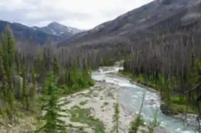
Trail description
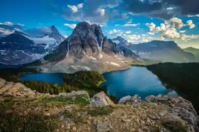
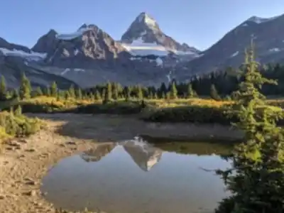
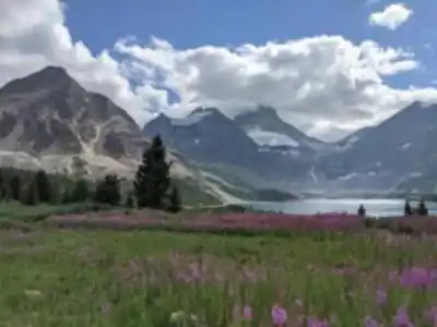
Mount Assiniboine Provincial Park earns its reputation as one of British Columbia's most extraordinary wilderness destinations, and the moment you catch your first glimpse of the park's namesake peak, you understand why. Rising to 3,618 meters (11,870 feet) in a near-perfect pyramid of limestone and quartzite, Mount Assiniboine has long been called the "Matterhorn of the Rockies" — a comparison that undersells nothing. The mountain catches alpenglow at dawn in a way that stops experienced mountaineers mid-stride.
The park covers 39,050 hectares (96,453 acres) of protected high-country terrain and forms part of the Canadian Rocky Mountain UNESCO World Heritage Site. That designation matters here in a tangible way: the absence of roads into the park has kept the ecosystem genuinely intact, and the wildlife, the water quality, and the silence all reflect that protection.
Getting There
No roads reach the park boundary, which is both the main logistical challenge and the defining feature of the experience. Most hikers approach via established trailheads in neighboring areas — Sunshine Village and Mount Shark are the two primary entry points, each involving significant distance and elevation gain. These are multi-day approaches, not warm-up hikes, and they demand proper backcountry fitness and preparation.
Helicopter service into the park is available for those who want to skip the approach or who are carrying gear for an extended stay. This option is genuinely useful for photography groups, families with mixed fitness levels, or anyone who wants to spend their time exploring the core alpine area rather than grinding through the approach corridors. It's not a shortcut for the lazy — it's a legitimate access strategy that opens the park to a wider range of visitors.
The Hiking Experience
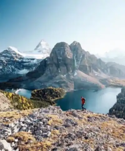
Most trail activity radiates outward from the Lake Magog area, where the turquoise water reflects Mount Assiniboine's face in conditions that make you stop and stare longer than you planned. The Assiniboine Lodge sits nearby, and the network of established trails from this hub covers a wide range of terrain and difficulty.
The trails move through distinct ecological zones in relatively short distances. You start in dense subalpine forest, push through open meadows thick with Indian paintbrush and alpine forget-me-nots in summer, and then break out into exposed alpine terrain where the views extend across the Continental Divide in every direction. Nub Peak is one of the standout destinations in this zone — the panorama from the top is the kind that recalibrates your sense of scale.
The terrain is honest about what it asks of you. Gentler routes through the meadows are accessible to hikers with moderate fitness, but the higher routes involve steep, rocky paths that require sure footing and comfort with exposure. The park's remote setting means that every route, regardless of technical difficulty, demands backcountry judgment and self-sufficiency.
Wildlife is a consistent part of the experience here. Mountain goats work the cliff faces with casual confidence, hoary marmots announce your presence from every rocky outcrop, and the park's isolation has kept animal behavior closer to natural patterns than you'll find in more heavily visited areas. Encounters feel earned rather than staged.
Backcountry Camping
The park operates entirely as a backcountry destination — there are no drive-in campgrounds, no day-use parking lots, no concession stands. Designated campsites maintain the wilderness character while providing basic facilities, and the Leave No Trace ethic is strictly applied. Everything you bring in, you carry out.
Camping at elevation in the Rockies requires genuine preparation. Temperatures drop hard at night even in July and August, weather systems move through quickly, and the distance from any trailhead means that gear decisions made at home have real consequences in the field. The upside is that the absence of light pollution at these campsites produces night skies that are genuinely difficult to describe — the Milky Way over the silhouette of Mount Assiniboine is the kind of image that stays with you.
Season and Conditions
The high elevation and northern latitude compress the hiking season significantly. Snow holds on in the high country from October through June in most years, and the reliable window runs from July through September. Even within that window, conditions can shift from warm and clear to a full snowstorm within hours, and the park's remoteness amplifies the consequences of being caught underprepared.
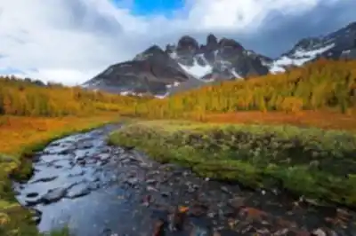
Early summer brings rushing snowmelt streams and the start of the wildflower bloom. By mid-summer the meadows are at peak color. Early fall delivers crisp air, quieter trails, and the golden transformation of the alpine larch — one of the more visually striking seasonal events in the Canadian Rockies. Each phase of the season offers something distinct, but all of them require the same level of preparation and respect for the environment.
Emergency evacuation from this park is complicated and expensive, which makes conservative decision-making and thorough trip planning not just good practice but a genuine safety requirement before you set foot on any trail here.
Recommended gear for this trail
As an Amazon Associate I earn from qualifying purchases.


Ready to go?
Everything you need to know before you goStarting Point
The mount assiniboine provincial park is located in British Columbia. To get to the start of the trails, take the Trans-Canada Highway to the town of Banff. From there, take the Sunshine Village Road to the Sunshine Village Ski Resort. The trailhead is located at the end of the road.
When?
Tuesday: 8:30 AM – 4:30 PM
Wednesday: 8:30 AM – 4:30 PM
Thursday: 8:30 AM – 4:30 PM
Friday: 8:30 AM – 4:30 PM
Saturday: Closed
Sunday: Closed
How much?
As an Amazon Associate I earn from qualifying purchases.
Affiliate links — LGPO may earn a commission at no extra cost to you.
- Hiking shoes Essential
- → Salomon Elixir Tour Mid WP · 203.38 $
- Layered clothing Essential
- Rain jacket Essential
- Trekking poles
- → Black Diamond Trail Ergo Cork · 69.99 $
- Headlamp
- → Petzl Actik Core 625 · 103.95 $
FAQ - Frequently asked questions
Everything you need to know
25 hikes under 2 hours from Montreal
Distance, elevation, parking and season for each one. The ones we go back to ourselves.
Get the guideSimilar hikes nearby
Discover other trails you might enjoy

Emerald Lake
Kootenay Rockies

Golden Skybridge
Kootenay Rockies
Mount Stephen
Kootenay Rockies
Magog, Lake
Kootenay Rockies
Iceline Trail
Kootenay Rockies
Valhalla Provincial Park
Kootenay Rockies
Hiking near Banff
187 trails to explore ~29 km away
We work hard to provide the most up-to-date and error-free data possible. If something seems incorrect, let us know! Your contribution helps the whole community.
Hikers' opinions
Be the first to review!
No hiker has shared their experience yet. Share your impressions and help other hikers!