

Ready to explore Wapta Falls? Here's everything you need to know before you go!
Discover the trail


Trail description
Description
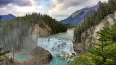
Wapta Falls stands as one of the most impressive waterfalls in Yoho National Park, earning its nickname as the "Niagara of Yoho" through sheer scale and power. This massive cascade spans approximately 150 meters (490 feet) across the Kicking Horse River and drops about 30 meters (98 feet), creating a thunderous display that can be heard long before you see it. The falls represent one of the largest waterfalls on the entire Kicking Horse River system, making this destination a standout attraction in the Kootenay Rockies region.
What sets Wapta Falls apart from other waterfalls in the Canadian Rockies is its incredible width rather than dramatic height. The Kicking Horse River spreads across a broad limestone ledge before plunging into the gorge below, creating a curtain of water that stretches nearly the length of two football fields. During peak snowmelt in late spring and early summer, the volume of water creates a mist that rises from the gorge and can be felt from the viewing areas above.
The Trail Experience
The journey to Wapta Falls begins at a well-marked trailhead located just off Highway 1, near the town of Field, British Columbia. This convenient access point makes the waterfall one of the more accessible major attractions in Yoho National Park. The trail itself covers 7 kilometers return, taking most hikers between 1.5 to 2 hours to complete at a comfortable pace.
The path follows a well-maintained route that gains only 30 meters of elevation, making it suitable for hikers of varying fitness levels. The gentle grade means families with children and less experienced hikers can tackle this trail without significant difficulty, though the distance still provides a satisfying outdoor workout.
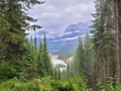
You'll spend most of the hike traveling through dense mixed forest dominated by spruce, fir, and pine trees. The forest canopy provides welcome shade during summer months, while the understory features typical Rocky Mountain flora including wildflowers that bloom from late June through August. The trail surface consists mainly of packed earth and forest duff, with some rocky sections and occasional muddy spots during wet periods.
As you progress along the trail, the sound of rushing water grows steadily louder, building anticipation for your first glimpse of the falls. The path generally follows the Kicking Horse River valley, though the river itself remains mostly hidden by vegetation until you near your destination.
Wildlife and Natural Features
The forested approach to Wapta Falls provides habitat for various wildlife species common to the region. Deer frequently browse in the area, particularly during early morning and evening hours. The diverse bird population includes species such as gray jays, Clark's nutcrackers, and various woodpecker species that thrive in the mature forest environment.
Keep your eyes open for signs of larger wildlife as well, including black bears and the occasional elk, though sightings along this particular trail are less common than in other areas of the park. The usual precautions regarding wildlife encounters apply, including making noise while hiking and properly storing any food items.
The geological story of Wapta Falls centers on the limestone bedrock that characterizes much of this region. The Kicking Horse River has carved through layers of sedimentary rock over thousands of years, creating the broad ledge that gives the falls their distinctive wide profile. The limestone also contributes to the river's distinctive turquoise color, particularly noticeable in the pools below the falls.
Viewing Areas and Photography
Upon reaching Wapta Falls, you'll find several vantage points that offer different perspectives of this natural spectacle. The main viewing area provides a panoramic view that captures the full width of the falls, allowing you to appreciate the massive scale of water flowing over the limestone ledge.
More adventurous visitors can explore additional viewpoints along the riverbank, though caution is essential as the rocks can be slippery from spray and the current below the falls is extremely powerful. These alternative positions offer unique angles for photography and a closer experience of the falls' raw power.
The mist created by the falling water supports a microclimate that keeps the immediate area cooler and more humid than the surrounding forest. This creates ideal conditions for certain plant species and provides welcome relief on hot summer days.
Planning Your Visit
Before heading out to Wapta Falls, check current weather conditions and any park advisories that might affect trail access. The trail typically remains accessible from late spring through fall, though early season conditions may include muddy sections and occasional snow patches in shaded areas.
Essential gear includes sturdy hiking footwear with good traction, as some sections of trail can be uneven or slippery. Pack adequate water and snacks for the journey, particularly during warmer months when the forested trail offers limited opportunities to refill water bottles. Weather in the mountains can change quickly, so bring layers including a rain jacket even on seemingly clear days.
The trail and falls area fall within Yoho National Park, so standard park regulations apply. This includes following Leave No Trace principles to preserve the pristine environment for future visitors. Stay on designated trails, pack out all garbage, and maintain appropriate distances from any wildlife you encounter.
Photography enthusiasts will find the best lighting conditions during mid-morning and late afternoon when the sun angle illuminates the falls without creating harsh shadows. The mist from the falls can create rainbow effects under the right conditions, particularly when the sun is positioned behind you as you face the waterfall.
Recommended gear for this trail


Ready to go?
Everything you need to know before you goStarting Point
The start of the trails at the wapta falls can be accessed from the parking lot located off Highway 1, approximately 5 km east of Field, British Columbia.
When?
How much?
- Hiking shoes Essential
- → Salomon Elixir Tour Mid WP · 203.38 $
- Layered clothing Essential
- Rain jacket Essential
- Trekking poles
- → Black Diamond Trail Ergo Cork · 69.99 $
- Headlamp
- → Petzl Actik Core 625 · 103.95 $
FAQ - Frequently asked questions
Everything you need to knowThe Essential Hiking Checklist
Everything you need for your next hike. Bilingual, printable, 1 page.
Download the free checklistSimilar hikes nearby
Discover other trails you might enjoy

Emerald Lake
Kootenay Rockies

Golden Skybridge
Kootenay Rockies

Mount Stephen
Kootenay Rockies
Bugaboo Provincial Park
Kootenay Rockies
Magog, Lake
Kootenay Rockies
Iceline Trail
Kootenay Rockies
Hiking near Banff
187 trails to explore ~71 km away
We work hard to provide the most up-to-date and error-free data possible. If something seems incorrect, let us know! Your contribution helps the whole community.
Hikers' opinions