


Ready to explore Hydro Cut? Here's everything you need to know before you go!
Discover the trail
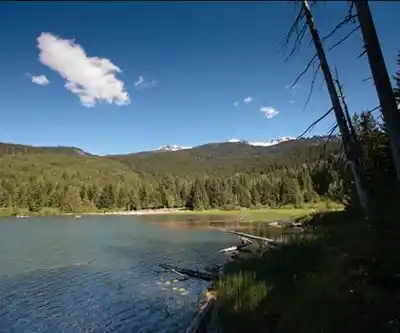
Trail description
Hydro Cut is a trail located in the Kootenay Rockies region of British Columbia, Canada. Tucked into one of the most scenic corners of the province, this trail draws hikers looking to explore the rugged, forested terrain that defines this part of BC. The Kootenay Rockies is known for its dramatic mountain landscapes, dense old-growth forests, and an extensive network of trails that range from casual walks to serious backcountry routes — and Hydro Cut fits into that broader tradition of accessible outdoor adventure in the region.
The Trail Experience
The name "Hydro Cut" is a common reference in BC trail culture, typically describing a route that follows or crosses a hydro line right-of-way — a cleared corridor cut through the forest to accommodate power infrastructure. These corridors often create unique trail conditions: open sky above, views that wouldn't otherwise exist through dense tree cover, and a mix of terrain that can include grassy sections, shrubby regrowth, and rocky ground depending on the elevation and aspect.
In the Kootenay Rockies context, a hydro cut trail often offers a different kind of hiking experience compared to fully forested routes. The open corridor can provide unexpected viewpoints toward surrounding ridgelines and valley bottoms, and the edge habitat created where the cut meets the forest is often rich with wildlife activity. Hikers in this region regularly encounter deer, birds of prey, and smaller mammals in these transitional zones.
Terrain and Setting
The Kootenay Rockies region sits at the intersection of the Columbia Mountains and the Rocky Mountains, giving it a distinctive character that sets it apart from other parts of British Columbia. Trails here tend to move through a mix of coniferous forest — dominated by species like western red cedar, Douglas fir, and various spruce — with understory vegetation that changes noticeably with elevation and moisture.
A hydro cut route in this environment will typically transition between shaded forest sections and open exposed stretches along the cleared corridor. The footing can vary: expect a mix of packed dirt, loose rock, and potentially some wet or muddy sections depending on the season and recent weather. Sturdy footwear is always a good call in this part of BC.
Getting There
The Kootenay Rockies region is served by several hub communities including Revelstoke, Golden, Invermere, Fernie, Nelson, and Castlegar, among others. Access to specific trailheads in the region typically involves a combination of paved highway driving and gravel forest service roads. It's worth checking local conditions before heading out, as forest service roads in BC can be affected by seasonal closures, washouts, or active logging traffic.
What to Know Before You Go
- Region: Kootenay Rockies, British Columbia — a mountainous area with variable weather year-round.
- Footwear: Hiking boots with good ankle support and grip are recommended given the mixed terrain typical of hydro cut routes.
- Wildlife awareness: The Kootenay Rockies is bear country. Carry bear spray, make noise on the trail, and know how to respond to wildlife encounters.
- Weather: Mountain weather in BC can change quickly. Check the forecast before heading out and bring layers regardless of the season.
- Water: Bring enough water for your outing. Natural water sources may be available along the route but should be treated before drinking.
- Leave No Trace: Pack out everything you bring in and stay on the established trail to protect the surrounding habitat.
Why Hike in the Kootenay Rockies
The Kootenay Rockies consistently ranks among BC's most rewarding regions for outdoor recreation. The combination of relatively uncrowded trails, stunning mountain scenery, and a strong local outdoor culture makes it a destination worth the drive for hikers from across the province and beyond. Trails like Hydro Cut offer a way to get into the landscape without necessarily committing to a full-day alpine objective — a solid option when you want to stretch your legs and get a feel for the terrain this corner of British Columbia has to offer.
Recommended gear for this trail
As an Amazon Associate I earn from qualifying purchases.


Ready to go?
Everything you need to know before you goWhen?
How much?
As an Amazon Associate I earn from qualifying purchases.
Affiliate links — LGPO may earn a commission at no extra cost to you.
- Hiking shoes Essential
- → Salomon Elixir Tour Mid WP · 203.38 $
- Layered clothing Essential
- Rain jacket Essential
- Trekking poles
- → Black Diamond Trail Ergo Cork · 69.99 $
- Headlamp
- → Petzl Actik Core 625 · 103.95 $
FAQ - Frequently asked questions
Everything you need to know
25 hikes under 2 hours from Montreal
Distance, elevation, parking and season for each one. The ones we go back to ourselves.
Get the guideSimilar hikes nearby
Discover other trails you might enjoy
Bridle Path
Vancouver Coast Mountains
Flora Lake
Vancouver Coast Mountains

Alouette Mountain
Vancouver Coast Mountains
Williamson Lake
Vancouver Coast Mountains
Brandywine Mountain
Vancouver Coast Mountains

Coliseum Mountain
Vancouver Coast Mountains
Hiking near Whistler
160 trails to explore ~3 km away
We work hard to provide the most up-to-date and error-free data possible. If something seems incorrect, let us know! Your contribution helps the whole community.
Hikers' opinions
Be the first to review!
No hiker has shared their experience yet. Share your impressions and help other hikers!