Hiking Parc des chutes - panoramic view
--°C
Loading...
See forecast →

Hiking in the Parc des chutes: trails, map and practical info

Bas-Saint-Laurent • Quebec

4.0 Appreciated by 12 hikers
François Dumaine
By François DumaineContributor since 2016Updated 19/06/2026
Difficulty
Easy
Distance
9 km
Elevation
50 m
Duration
2h30
Max altitude
50 m

Explore stunning waterfalls on this 9.1 km easy loop through Bas-Saint-Laurent's lush landscapes. 2h30 of hiking with minimal elevation gain—perfect for families seeking natural beauty near Rivière-du-Loup.

Recommended for :
Beginners

Ready to explore Parc des chutes? Here's everything you need to know before you go!

Discover the trail

Oh no! We don't have any photos 😢

This trail hasn't been captured yet. Be the first to share your adventure!

Trail description

The Waterfall

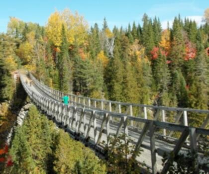
The main attraction is a stunning 33-metre-high waterfall that serves as the centerpiece of the park. The cascade can be admired from multiple angles thanks to two footbridges, one of which overlooks the chasm directly. The sound builds before you even see it, and the air feels noticeably cooler and fresher at the base. It's a strong photographic subject at any time of day, and the surrounding landscape frames it well. Plan to spend some time here rather than just passing through.

Trail Details

The main loop covers 9.1 km with only 50 metres of elevation gain, which makes this one of the flatter options in the region. You're not here to grind out a climb — you're here for the scenery, the sound of moving water, and a comfortable pace through the forest. Most people complete the trail in around 2 hours 30 minutes, though that's easy to stretch if you stop at the falls or take a break at one of the picnic areas.

The terrain is well-maintained and clearly signed throughout, so route-finding isn't a concern. The paths are suitable for hikers of most fitness levels, and the easy difficulty rating reflects that. That said, footwear with some grip is always a good call near waterfall areas where the ground can get slick.

Flora and Wildlife

The forest along the trail is a mix of conifers and deciduous trees typical of the Bas-Saint-Laurent region. The canopy provides good shade on warm days, and the understory is active enough to reward anyone paying attention. Birdwatchers will find plenty to look at, and deer sightings in the area are not uncommon, particularly in quieter morning hours. The park's natural corridor supports a range of local species, so it's worth slowing down and keeping your eyes open beyond the trail itself.

Facilities

The park includes designated picnic areas, children's play areas, and toilet facilities that make it easy to turn this into a half-day outing. Bringing lunch and eating near the falls or in a shaded clearing along the trail is a straightforward way to extend the experience. Parking is available on-site, and access from Rivière-du-Loup is well-indicated, making the logistics of getting here uncomplicated.

Recommended gear for this trail

LGPO Pick
Elixir Tour Mid WP
Salomon
Elixir Tour Mid WP
4.5 (2847 reviews)
Waterproof mid-height boot ideal for rocky terrain
203.38 $
See price
Daylite Plus 20L
Osprey
Daylite Plus 20L
4.7 (3215 reviews)
Lightweight and versatile for day hikes
109.99 $
See price
Most Popular
Wide Mouth 1L
Nalgene
Wide Mouth 1L
4.8 (12540 reviews)
Unbreakable and BPA-free — a hiking essential
23.11 $
See price
Best Value
Trail Ergo Cork
Black Diamond
Trail Ergo Cork
4.4 (1456 reviews)
Comfortable cork grip for long ascents
69.99 $
See price
Actik Core 625
Petzl
Actik Core 625
4.6 (1893 reviews)
USB rechargeable with 600 lumens for early starts
103.95 $
See price
Affiliate links — LGPO may earn a commission at no extra cost to you.

Ready to go?

Everything you need to know before you go

Where?

Address
6891 Boul Gouin O, Montréal, QC H4K 1B5, Canada
GPS coordinates
47.8317, -69.5304
Phone
(514) 713-6829

Starting Point

To get to the parc des chutes trails, you must go to Rivière-du-Loup. From there, take Route 132 East and head towards Saint-Siméon. After crossing Saint-Siméon, continue on route 132 East and head towards Notre-Dame-du-Portage. At Notre-Dame-du-Portage, turn left onto Route 132 West and head towards Les Chutes.

The trailhead for parc des chutes is located about 1 km from the village of Saint-Jean-de-la-Lande, on Route 132.

When?

Opening hours
From sunrise to sunset
Varies by season
Best season
Fall
Spectacular colors
Best time
Early morning
Less crowded
Weather (next days)
Loading

How much?

Entry fees
Adult
Not available
Child
What to bring?
Gear
Download the PDF checklist
Water & food
2L minimum
No water point on the trail
Bring energy snacks for a 4h+ hike
Good to know
Park rules
No dogs
Safety
Download the GPX before you go
Limited cellular coverage on the trail
Slippery after rain
Be careful on rocky sections
In an emergency
Emergency
911
Parking GPS
47.8317, -69.5304
Center
(514) 713-6829

Hikers' opinions

4.0
8 Reviews
P
Philippe
Dec 3, 2025
Completed the hike without difficulty, though I found it somewhat crowded during my visit. The waterfall views are nice but relatively brief. Entrance fees apply, so factor that into your trip planning. Best visited on quieter weekdays.
D
David
Nov 22, 2025
Had a serene morning experience on this easy trail. The cooler temperatures made hiking comfortable and enjoyable. I observed several bird species throughout the walk and was captivated by the soothing sounds of the waterfall. An excellent destination for anyone seeking peaceful reconnection with nature.
M
Marie
Oct 15, 2025
Visited during fall and found the landscape absolutely stunning with vibrant foliage. The trail was somewhat muddy due to recent rainfall, making certain sections slippery underfoot. Despite this minor challenge, it remains an accessible hike perfect for nature photographers seeking beautiful seasonal shots.
I
Isabelle
Jul 10, 2025
Pleasant afternoon hike with manageable terrain and clear trail markings. The natural surroundings provide good opportunities for wildlife observation and photography. Note that parking facilities require a fee, so budget accordingly for your visit.
SJ
Sarah J.
Oct 10, 2023
I visited the park in autumn, and while the views were lovely with the changing leaves, the trails were a bit muddy from recent rains. It’s an easy hike, but be prepared for slick paths. If you enjoy nature photography, bring your camera for some beautiful shots!

FAQ - Frequently asked questions

Everything you need to know
Easy
50.00 M
50.00 M
2h30
No
No
The Parc Des Chutes trail is rated as Easy difficulty, making it accessible for most hikers. With only 50 meters of elevation gain over 9.1 km, it's a relatively flat and manageable hike.
The Parc Des Chutes trail is 9.1 km long with 50 meters of elevation gain. The actual hiking time will depend on your pace and how often you stop to enjoy the scenery.
No, dogs are not allowed on the Parc Des Chutes trail. Plan to leave your furry companions at home for this hike.
Yes, the Parc Des Chutes trail is perfect for beginners and families with its Easy difficulty rating and minimal elevation gain of only 50 meters. The 9.1 km distance makes it a good introduction to longer hikes without technical challenges.
The Parc Des Chutes trail is open from sunrise to sunset. Check the current season's sunrise and sunset times to plan your visit accordingly.
Didn't find your answer?
Free 1 pages

The Essential Hiking Checklist

Everything you need for your next hike. Bilingual, printable, 1 page.

Download the free checklist
Top 10 best hiking in Bas-Saint-Laurent
Our ranking based on hiker reviews

Hiking near Quebec City

40 trails to explore ~170 km away

View trails
Did you spot an error?

We work hard to provide the most up-to-date and error-free data possible. If something seems incorrect, let us know!

Update : June 2026