

Ready to explore Parc du Mont-Saint-Mathieu? Here's everything you need to know before you go!
Discover the trail

Trail description
Description
Parc du Mont-Saint-Mathieu is tucked into the Bas-Saint-Laurent region and feels like the kind of place locals quietly return to again and again. It’s a solid pick if you want a day outside that’s focused on trail time, forest scenery, and a summit viewpoint without needing a complicated plan. The overall vibe is calm and nature-forward: you spend most of your time surrounded by trees, with the reward of open views as you gain elevation.
Trail network and route options
The park offers an array of trails that cater to all levels of hikers, so you don’t have to be a hardcore trekker to enjoy it. If you’re newer to hiking, you can choose a path that keeps the effort manageable and lets you settle into the rhythm of walking in the woods. If you’re more experienced, you can pick something that feels more like a proper climb to the top.
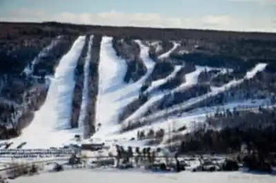
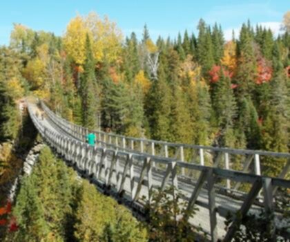
What stands out here is how the trails are described as well-maintained and designed to move you through different settings. Expect sections that wind through lush forest—shaded, quiet, and sheltered—and then moments where the trees thin out and the landscape opens up. Those transitions are a big part of what makes the hike feel varied, even within a relatively compact area.
If you’re planning around distance, the park’s trail distance is listed at 10.1 km, with 335 m of elevation gain. That combination usually translates into a satisfying outing where you’ll feel the climb but still have plenty of time to stop for photos and enjoy the lookout without rushing.
Terrain, atmosphere, and what the hike feels like
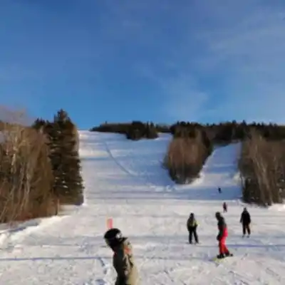
Most of your time on foot is spent in forest. “Lush” is a good cue for what to expect: greenery, a sense of being tucked away from roads and day-to-day noise, and that steady, immersive feeling that comes with hiking under a canopy. The trails are described as winding, which often means gentle turns, gradual changes in scenery, and a route that feels like it’s leading you somewhere rather than simply cutting straight up a slope.
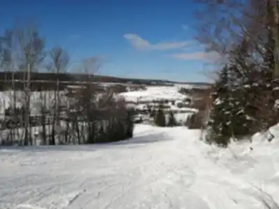
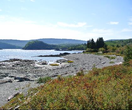
As you climb higher, you’ll notice the experience shift from enclosed forest walking to more open viewpoints. The park is known for “breathtaking vistas,” which is exactly what you want in the Bas-Saint-Laurent: a mix of rolling terrain and pockets of water that make the landscape look layered and expansive. This is the kind of terrain where even short breaks feel restorative—step off to the side, listen for birds, and take in the stillness.
Summit views and photo stops
One of the main reasons people come to Parc du Mont-Saint-Mathieu is the panoramic view from the summit. The ascent pays off with sweeping views over the surrounding landscape, including rolling hills and pristine lakes. Plan to spend time at the top—this is where you’ll want to slow down, look in every direction, and take a few photos. Because the viewpoint is highlighted as a major feature, it’s worth carrying what you need to be comfortable lingering: water, a layer for wind at higher elevation, and whatever snacks make you happy to sit and soak it in.
Even if you’re not usually the “take photos” type, the summit is described as having countless photo opportunities. The mix of hills and lakes gives you natural depth in your shots, and the change from forest to open views makes the overlook feel like a real destination rather than just a turnaround point.
Other activities beyond hiking
Hiking is the obvious draw, but the park isn’t limited to foot travel. During the warmer months, you can also enjoy mountain biking, which makes it a good option if your group includes mixed interests or if you want to explore more ground than you’d cover on a single hike. The park also mentions leisurely walks along scenic paths, which is helpful if you’re visiting with someone who prefers a gentle pace or if you want a lower-key outing that’s still outdoors.
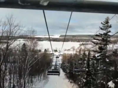
In winter, Parc du Mont-Saint-Mathieu shifts into a snow-focused destination. The trails and terrain become a base for snowshoeing and cross-country skiing, turning the same forest-and-viewpoint setting into a completely different experience—quiet, bright, and often more peaceful than summer. If you’re visiting in the cold season, think in terms of steady movement and layering: you’ll warm up while climbing, and cool down quickly during stops.
Wildlife and nature watching
The park is committed to preserving its natural environment, and that shows up in the experience: you’re not just passing through trees—you’re moving through habitat. As you hike, keep an eye out for local flora and fauna. It’s the kind of place where slowing down pays off, especially in the quieter stretches of trail where you can listen for movement in the brush or bird calls above you.
You might spot native bird species, and there’s also the chance of seeing small mammals. Early in the day and later in the afternoon are often good times to be attentive, especially if the trails are quieter. Even when you don’t see wildlife, noticing tracks, sounds, and changes in plant life adds a lot to the hike and makes the forest sections feel more alive.
Facilities and how to plan your visit
Parc du Mont-Saint-Mathieu works well as a day trip, but it can also fit into a longer stay in the region if you’re exploring Bas-Saint-Laurent. For comfort and downtime, picnic areas are available, which makes it easy to build a relaxed mid-hike or post-hike break into your plan. A picnic is also a good way to extend your time at the park without feeling like you need to rush from the trailhead to the summit and straight back.
If you’re coming for a straightforward hiking day, the simplest approach is to pack for a few hours outdoors: water, snacks or lunch for the picnic area, and a light layer for changing conditions—especially if you expect to spend time at the summit viewpoint. The trails are described as well maintained, but it’s still worth wearing footwear you trust for forest paths and for any steeper sections on the ascent.
This park suits a range of visitors: hikers looking for a satisfying climb and a panoramic payoff, outdoor enthusiasts wanting a mix of trail and scenery, and anyone who just wants to step into nature and disconnect for a while. The combination of forest walking, open vistas, and the option to return in different seasons is what makes Parc du Mont-Saint-Mathieu stand out as a reliable, repeatable destination in Bas-Saint-Laurent.
Recommended gear for this trail


Ready to go?
Everything you need to know before you goStarting Point
To access the hiking trails, head to the main parking lot located at 126 Rue Principale, Saint-Mathieu-de-Rioux, Quebec. This is the primary starting point for most of the trails in the area.
When?
How much?
- Hiking shoes Essential
- → Salomon Elixir Tour Mid WP · 203.38 $
- Layered clothing Essential
- Rain jacket Essential
- Trekking poles
- → Black Diamond Trail Ergo Cork · 69.99 $
- Headlamp
- → Petzl Actik Core 625 · 103.95 $
FAQ - Frequently asked questions
Everything you need to knowThe Essential Hiking Checklist
Everything you need for your next hike. Bilingual, printable, 1 page.
Download the free checklistSimilar hikes nearby
Discover other trails you might enjoy
Parc National Du Bic
Bas-Saint-Laurent
Canyon Des Portes De L'enfer
Bas-Saint-Laurent

Beausejour Park
Bas-Saint-Laurent
Parc Des Chutes
Bas-Saint-Laurent

Lac Anna
Bas-Saint-Laurent

Sentier du Cabouron de Saint-Germain
Bas-Saint-Laurent
Hiking near Quebec City
40 trails to explore ~223 km away
We work hard to provide the most up-to-date and error-free data possible. If something seems incorrect, let us know! Your contribution helps the whole community.
Hikers' opinions