
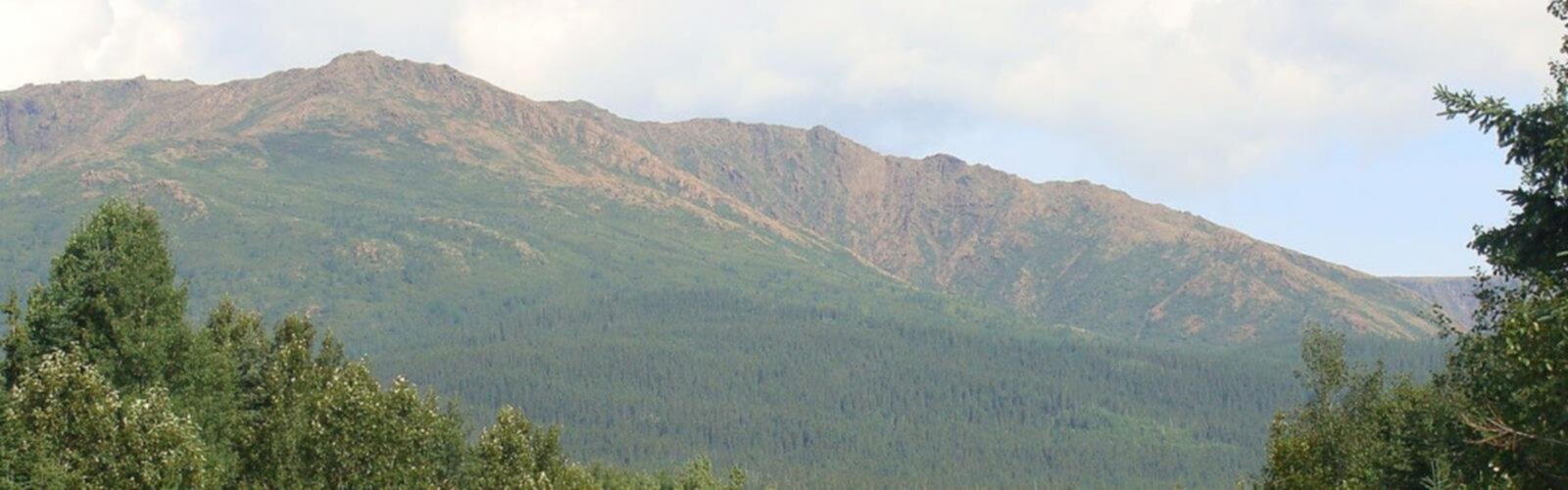

Ready to explore Mont Albert? Here's everything you need to know before you go!
Discover the trail


Photos: Sarah-Anne Seale — Google Maps (Google Maps) Benoit Thivierge — Google Maps (Google Maps)
Available trails
| TrailTrails | Dist.Distance | GainElevation | TimeDuration | Difficulty | GPX |
|---|---|---|---|---|---|
|
Advanced
|
12.6 km | 850 m | 4h | Advanced |
Trail description
Mont Albert is a mountain in the Chic-Choc range within Gaspésie National Park, on the Gaspé Peninsula of eastern Quebec. At 1,151 m (3,776 ft), it ranks among the highest summits in southern Quebec and draws hikers who want a genuine mountain day — sustained climbing, high-elevation terrain, and the kind of scale that's hard to find elsewhere in the province.
Where you're going
The Chic-Chocs are the defining feature of the Gaspé Peninsula's interior, and Mont Albert sits at the heart of that range. This isn't an isolated peak — it's part of a broader mountain landscape where ridgelines, high plateaus, and neighboring summits all contribute to the feel of being in a real range. Gaspésie National Park protects this terrain, which means the environment around the mountain is intact and the experience reflects what the Chic-Chocs actually are: one of Quebec's most rugged and rewarding mountain regions.
The elevation matters here. At 1,151 m, Mont Albert reaches into territory where the vegetation, the weather, and the views all shift noticeably from what you'd find on lower trails in the province. That transition — from forested lower slopes to more open, exposed high ground — is a big part of why people make the trip to Gaspésie specifically to hike this mountain.
The hike at a glance
- Distance: 12.6 km
- Elevation gain: 850 m
- Difficulty: Hard
- Estimated time: 5h30
The numbers are honest about what this hike asks of you. Gaining 850 m over 12.6 km means the climbing is consistent — this isn't a route that front-loads the effort and then flattens out. The "Hard" rating reflects both the sustained elevation gain and the mountain environment itself, where conditions can change and the terrain demands attention. The estimated 5h30 is a reasonable benchmark, but your actual time will depend on your fitness, your pace on technical ground, and how long you spend at the top.
What the day feels like
Mont Albert rewards the kind of hiker who's comfortable working steadily uphill for an extended stretch. The climb is the core of the experience — you'll feel it building through the lower slopes and into the upper mountain, where the terrain opens up and the views start to justify the effort. By the time you reach the summit area, you're on top of one of the highest points in southern Quebec, with the Chic-Chocs spread out around you and the Gaspé Peninsula extending in every direction.
The combination of distance and elevation gain suggests a route that's efficient rather than wandering — more vertical than horizontal, which means the effort is front and center throughout the outing. That's not a complaint; it's the point. People come to Mont Albert because they want a mountain day, and the route delivers exactly that.
The upper mountain, given the elevation, tends to feel more alpine than most Quebec hiking destinations. Expect the environment to shift as you gain height — the forest gives way to more exposed terrain, and the summit plateau carries that open, high-elevation character that defines the Chic-Chocs at their best.
A bit of history
Mont Albert was named in honor of Prince Albert of Saxe-Coburg and Gotha, the husband of Queen Victoria. The name traces back to the first recorded ascent: geologist Alexander Murray reached the summit on August 26, 1845 — the Prince's birthday. It's a small detail, but it's a good one. This mountain has been on the map, literally and figuratively, for well over 175 years.
How to approach the day
A hike rated Hard with 850 m of elevation gain in a national park mountain setting deserves to be treated like a mountain objective. A few things worth keeping in mind:
- Pace yourself early. The climb is long enough that burning out in the first hour will cost you on the upper mountain. Start steady and let the elevation come to you.
- Your knees will notice the descent. What goes up 850 m has to come back down, and the return trip on a hard mountain hike is where tired legs make mistakes. Trekking poles help.
- Weather at elevation. At 1,151 m in the Chic-Chocs, conditions on the upper mountain can differ significantly from what you left at the trailhead. Bring layers and be ready to adjust.
- The 5h30 estimate is a guide, not a deadline. Build in time for breaks, for the summit, and for the descent — especially if the terrain is wet or technical.
Mont Albert sits within Gaspésie National Park, so access and trail conditions are managed by the park. It's worth checking current conditions and any access requirements before you head out, particularly early and late in the hiking season when the upper mountain can hold snow well past when the lower trails are clear.
For many hikers, Mont Albert represents exactly what a trip to Gaspésie is for: a serious climb in a serious mountain range, on a peak with real elevation and a long history, in one of the most distinctive landscapes Quebec has to offer.
Services and amenities
This information may vary by season.
The Essential Hiking Checklist
Everything you need for your next hike. Bilingual, printable, 1 page.
Get your free hiking checklistRecommended gear for this trail
As an Amazon Associate I earn from qualifying purchases.


Ready to go?
Everything you need to know before you goWhen?
How much?
As an Amazon Associate I earn from qualifying purchases.
Affiliate links — LGPO may earn a commission at no extra cost to you.
- Hiking shoes Essential
- → Salomon Elixir Tour Mid WP · 203.38 $
- Layered clothing Essential
- Rain jacket Essential
- Trekking poles
- → Black Diamond Trail Ergo Cork · 69.99 $
- Headlamp
- → Petzl Actik Core 625 · 103.95 $
FAQ - Frequently asked questions
Everything you need to knowSimilar hikes nearby
Discover other trails you might enjoy

Parc National De La Gaspésie
Gaspésie
Plage Haldimand
Gaspésie

Réserve Faunique De Matane
Gaspésie

Mont Saint-Pierre
Gaspésie

Mont Vallieres-de-Saint-Real
Gaspésie

Parc National Du Canada Forillon
Gaspésie
Hiking near Fredericton
11 trails to explore ~328 km away
We work hard to provide the most up-to-date and error-free data possible. If something seems incorrect, let us know! Your contribution helps the whole community.
Hikers' opinions
Be the first to review!
No hiker has shared their experience yet. Share your impressions and help other hikers!