
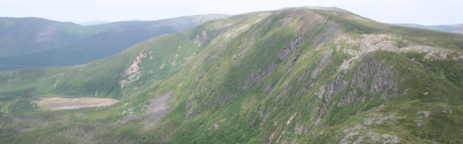

Ready to explore Mont de la Table? Here's everything you need to know before you go!
Discover the trail
Oh no! We don't have any photos 😢
This trail hasn't been captured yet. Be the first to share your adventure!Trail description
Mont de la Table is one of those summits in Gaspésie that doesn't get as much attention as its famous neighbors, but rewards the hikers who make the effort to seek it out. Tucked into the rugged landscape of the Gaspésie–Îles-de-la-Madeleine region of Quebec, this mountain offers a genuine backcountry feel without requiring an expedition-level commitment. If you're looking for a hike that feels earned without being punishing, Mont de la Table deserves a spot on your list.
The Terrain
The trail up Mont de la Table moves through classic Gaspésian forest — dense boreal cover dominated by balsam fir and black spruce, with the occasional white birch breaking up the canopy. The ground underfoot shifts as you gain elevation, transitioning from rooted forest floor to rockier, more exposed terrain near the upper sections. The mountain's name — "Table Mountain" — hints at its character: a relatively flat summit plateau that opens up after a sustained climb through the trees.
The upper reaches of the trail can be wet and muddy, especially in spring and after heavy rain. Waterproof footwear is a smart call here. The trail itself is not heavily groomed, which is part of its appeal — this is a place where you're actually moving through the landscape rather than along a manicured path.
What to Expect on the Way Up
The ascent is steady and consistent. You won't find dramatic switchbacks or technical scrambling, but the trail doesn't let up much either. It's the kind of climb that gets your legs working and your lungs engaged without ever feeling dangerous. Hikers with a moderate fitness level and some trail experience will feel comfortable here. First-timers to mountain hiking should be aware that the terrain is uneven and requires attention to footing throughout.
As you move higher, the forest begins to thin and the views start to open up. The Gaspésie landscape is genuinely spectacular from elevation — rolling forested ridges, river valleys cutting through the terrain, and on a clear day, a sense of just how vast and wild this corner of Quebec really is. The summit plateau delivers on that promise, offering wide sightlines that make the climb feel worth every step.
The Summit Experience
The flat top of Mont de la Table is what sets this hike apart from a standard peak-and-back trail. Rather than a single rocky high point, you arrive at an open area where you can move around, take in views from different angles, and actually spend some time without feeling perched on a narrow ledge. It's a good place to eat lunch, catch your breath, and take in the scale of the surrounding Gaspésie wilderness.
The summit area sits above the treeline, which means exposure to wind and weather. Even on warm days at lower elevations, conditions up top can be noticeably cooler and windier. Pack an extra layer regardless of the season — this is standard practice in Gaspésie, where mountain weather moves fast and doesn't always match the forecast.
Wildlife and Natural Environment
Gaspésie is known for its wildlife, and Mont de la Table sits within a region where moose sightings are genuinely common. Keep your eyes open in the early morning and evening hours, particularly near any wet areas or forest edges along the trail. The boreal forest here also supports a healthy bird population — listen for the calls of white-throated sparrows, Swainson's thrushes, and various woodpecker species as you move through the trees.
The vegetation on the upper slopes includes subalpine plant communities that are characteristic of Gaspésie's higher terrain. These ecosystems are fragile, so staying on the marked trail — especially near the summit — is important for keeping the area intact for future visitors.
Getting There
Mont de la Table is located in the Gaspésie–Îles-de-la-Madeleine region of Quebec. Access details and current trail conditions are best confirmed locally before heading out, as road and trailhead access in this part of Quebec can vary by season and may be affected by forestry or weather conditions. Checking with regional tourism offices or local outdoor clubs before your visit is always a good idea in Gaspésie.
Practical Tips
- Footwear: Waterproof hiking boots are strongly recommended. The trail can be wet and muddy in sections, and the rocky upper terrain benefits from solid ankle support.
- Layers: Bring a wind layer and an insulating mid-layer even in summer. Summit conditions in Gaspésie can change quickly.
- Water: Carry enough water for the full hike. There are no guaranteed water sources along the trail that are safe to drink without treatment.
- Navigation: Download an offline map before you go. Cell service in this part of Gaspésie is unreliable, and having a map on your device can make a real difference if you lose the trail.
- Timing: Starting early gives you the best chance of clear summit views and helps you avoid afternoon weather that can roll in quickly over the Gaspésie highlands.
- Leave No Trace: Pack out everything you bring in. The summit plateau and subalpine zones are sensitive environments that see enough pressure from hikers — do your part to keep them clean.
Who This Hike Is For
Mont de la Table is a solid choice for hikers who have some trail experience and want a genuine mountain outing in one of Quebec's most scenic regions. It's not the place for a casual stroll, but it's also not a technical climb — it sits comfortably in the middle ground that experienced day hikers will appreciate. The combination of sustained forest hiking, an open summit plateau, and the raw character of the Gaspésie landscape makes this a hike that sticks with you.
The Essential Hiking Checklist
Everything you need for your next hike. Bilingual, printable, 1 page.
Get your free hiking checklistRecommended gear for this trail
As an Amazon Associate I earn from qualifying purchases.


Ready to go?
Everything you need to know before you goWhen?
How much?
As an Amazon Associate I earn from qualifying purchases.
Affiliate links — LGPO may earn a commission at no extra cost to you.
- Hiking shoes Essential
- → Salomon Elixir Tour Mid WP · 203.38 $
- Layered clothing Essential
- Rain jacket Essential
- Trekking poles
- → Black Diamond Trail Ergo Cork · 69.99 $
- Headlamp
- → Petzl Actik Core 625 · 103.95 $
FAQ - Frequently asked questions
Everything you need to knowSimilar hikes nearby
Discover other trails you might enjoy

Parc National De La Gaspésie
Gaspésie
Plage Haldimand
Gaspésie

Réserve Faunique De Matane
Gaspésie

Mont Saint-Pierre
Gaspésie

Mont Vallieres-de-Saint-Real
Gaspésie

Parc National Du Canada Forillon
Gaspésie
Hiking near Moncton
14 trails to explore ~335 km away
We work hard to provide the most up-to-date and error-free data possible. If something seems incorrect, let us know! Your contribution helps the whole community.
Hikers' opinions
Be the first to review!
No hiker has shared their experience yet. Share your impressions and help other hikers!