
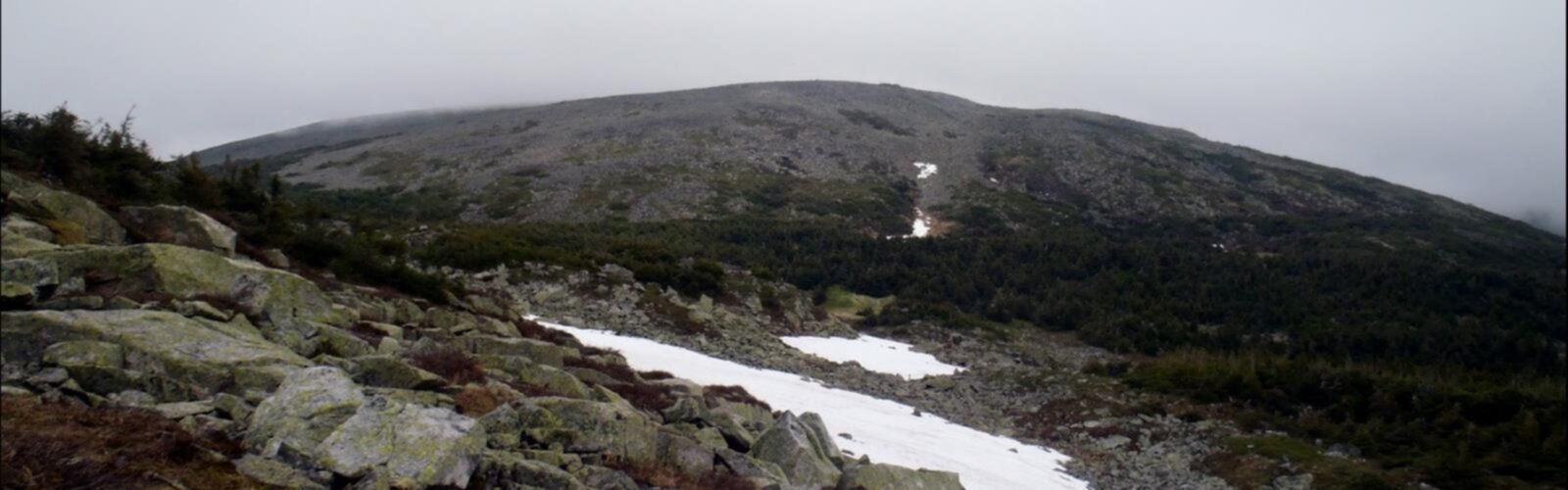

Ready to explore Mont Jacques-Cartier? Here's everything you need to know before you go!
Discover the trail
Oh no! We don't have any photos 😢
This trail hasn't been captured yet. Be the first to share your adventure!Trail description
Mont Jacques-Cartier is one of the most iconic hikes in Québec — and honestly, one of the best in the country. Standing as the highest peak in the Chic-Choc Mountains within Parc national de la Gaspésie, this summit draws hikers who want something genuinely wild, genuinely remote, and genuinely rewarding. If you're looking for a hike that feels like a true alpine experience in eastern Canada, this is it.
The Terrain
The trail to Mont Jacques-Cartier takes you through a dramatic transition of ecosystems. You start in boreal forest — dense spruce and fir, the kind of forest that smells incredible after rain — and as you gain elevation, the trees get shorter and more twisted until they disappear entirely. Above treeline, you're walking through open tundra-like terrain, with low-lying vegetation, exposed rock, and sweeping views in every direction. The landscape up here feels more like Labrador or the Arctic than what most people picture when they think of Québec.
The upper section of the trail is rocky and can be uneven underfoot, so good ankle support matters. The summit plateau is wide and open, which means it's fully exposed to wind and weather — conditions can shift quickly, even in summer.
Wildlife on the Summit
Mont Jacques-Cartier is one of the few places in Québec where you have a realistic chance of seeing woodland caribou. A protected herd lives on the high plateaus of Parc national de la Gaspésie, and the summit area of Mont Jacques-Cartier is part of their range. Because of this, access to the summit is managed carefully by the park — hikers are required to stay on marked trails and follow specific guidelines to minimize disturbance to the herd. This isn't just a formality; the caribou are genuinely at risk, and the park takes their protection seriously.
Beyond caribou, the alpine zone is also habitat for species adapted to harsh, high-elevation conditions. Keep your eyes open and your voice low — wildlife encounters here are real, not staged.
Access and Park Regulations
Mont Jacques-Cartier is located within Parc national de la Gaspésie, managed by Sépaq (Société des établissements de plein air du Québec). Entry fees apply, and you'll need to pay the daily access fee or hold a valid Sépaq annual pass. Reservations or registration at the park office may be required before heading out on this trail — check directly with the park before your visit, as procedures can change seasonally.
The trailhead is accessible by road within the park. Parking is available at the designated lot near the trail departure point. Dogs are not permitted on this trail, in keeping with the park's wildlife protection measures for the caribou herd. Bikes are also not permitted.
What Makes This Hike Stand Out
A lot of hikes in eastern Canada promise "alpine feel" but deliver something closer to a forested ridge walk. Mont Jacques-Cartier actually delivers. The transition from closed-canopy boreal forest to open tundra is abrupt and striking, and the summit views — on a clear day — stretch across the Chic-Choc range and toward the St. Lawrence. There's a real sense of being somewhere genuinely high and genuinely exposed.
The presence of caribou adds a dimension that's hard to find anywhere else in the province. Even if you don't spot them, knowing they're out there changes how you move through the landscape. It's a reminder that this isn't just a scenic backdrop — it's functioning wilderness.
Practical Tips
- Weather changes fast at elevation. Even in July and August, temperatures on the summit can drop significantly, and wind is almost always a factor. Bring an extra layer and a rain shell regardless of the forecast.
- Start early. Afternoon thunderstorms are common in summer in the Gaspésie, and you don't want to be on an exposed summit when they roll in.
- Stay on the trail. This is non-negotiable here. The alpine vegetation is fragile and slow to recover, and the caribou protection rules are enforced. Stick to the marked path.
- Bring enough water. There are no reliable water sources on the upper section of the trail. Carry what you need from the start.
- Check in with the park. Sépaq staff at Parc national de la Gaspésie can give you current trail conditions, caribou activity updates, and any access restrictions in effect on the day of your visit.
Getting There
Parc national de la Gaspésie is located in the Gaspésie–Îles-de-la-Madeleine region of Québec. The park's main entrance and visitor services are accessible via Route 299, which runs through the interior of the Gaspésie peninsula. The drive itself is part of the experience — the Chic-Choc Mountains rise dramatically from the surrounding landscape, and the approach through the park gives you a good sense of the scale of the terrain you're about to hike into.
Cell service is limited to nonexistent in much of the park, so download offline maps before you leave and make sure someone knows your plans and expected return time.
Best Season
The trail to Mont Jacques-Cartier is typically accessible from late June through early October, depending on snowpack. Snow can linger on the upper sections well into June, and early-season conditions can be icy and unpredictable. The park can provide current conditions and confirm when the trail is open for the season. Fall hiking here — when the boreal forest below is turning and the air is sharp and clear — is genuinely spectacular.
The Essential Hiking Checklist
Everything you need for your next hike. Bilingual, printable, 1 page.
Get your free hiking checklistRecommended gear for this trail
As an Amazon Associate I earn from qualifying purchases.


Ready to go?
Everything you need to know before you goWhen?
How much?
As an Amazon Associate I earn from qualifying purchases.
Affiliate links — LGPO may earn a commission at no extra cost to you.
- Hiking shoes Essential
- → Salomon Elixir Tour Mid WP · 203.38 $
- Layered clothing Essential
- Rain jacket Essential
- Trekking poles
- → Black Diamond Trail Ergo Cork · 69.99 $
- Headlamp
- → Petzl Actik Core 625 · 103.95 $
FAQ - Frequently asked questions
Everything you need to knowSimilar hikes nearby
Discover other trails you might enjoy

Parc National De La Gaspésie
Gaspésie
Plage Haldimand
Gaspésie

Réserve Faunique De Matane
Gaspésie

Mont Saint-Pierre
Gaspésie

Mont Vallieres-de-Saint-Real
Gaspésie

Parc National Du Canada Forillon
Gaspésie
Hiking near Moncton
14 trails to explore ~334 km away
We work hard to provide the most up-to-date and error-free data possible. If something seems incorrect, let us know! Your contribution helps the whole community.
Hikers' opinions
Be the first to review!
No hiker has shared their experience yet. Share your impressions and help other hikers!