
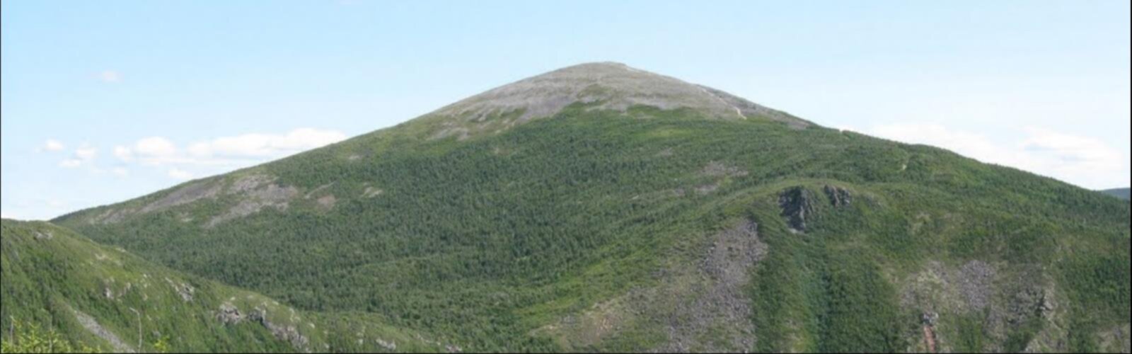

Ready to explore Mont Richardson? Here's everything you need to know before you go!
Discover the trail
Oh no! We don't have any photos 😢
This trail hasn't been captured yet. Be the first to share your adventure!Trail description
Mont Richardson is one of those summits in the Gaspésie region that rewards the effort with a genuine sense of arrival. Tucked into the rugged landscape of the Gaspésie–Îles-de-la-Madeleine region of Quebec, this mountain offers hikers a real taste of what makes this corner of the province so compelling — dramatic terrain, wild forest, and views that open up in a way that feels earned.
The Terrain
The approach to Mont Richardson takes you through classic Gaspésie forest — a mix of boreal conifers and hardwoods that shifts as you gain elevation. The lower sections of the trail tend to be rooted and rocky underfoot, typical of the region's trails where the bedrock sits close to the surface. As you climb, the vegetation thins and the trail becomes more exposed, giving you a clearer sense of the mountain's profile and the ridgelines surrounding it.
The upper sections are where the character of the hike really comes through. The terrain gets more rugged, with open rocky stretches that require a bit of attention to footing. This is not a casual stroll — Mont Richardson asks you to be present and engaged the whole way up.
What to Expect on the Trail
Hikers heading to Mont Richardson should come prepared for a mountain experience in the full sense. The Gaspésie is known for weather that can shift quickly, and this summit is no exception. Even on a clear morning in the valley, conditions at the top can be cooler and windier than expected. Layering is always a smart call here.
The trail surface varies throughout the route. You'll encounter sections of exposed root systems, loose rock, and steeper pitches that make trekking poles a worthwhile addition to your pack. Good footwear with ankle support and solid grip is strongly recommended — trail runners can work for experienced hikers, but a proper hiking boot will serve most people better on this kind of terrain.
The summit area offers the payoff: panoramic views over the surrounding Gaspésie landscape, with the region's characteristic mix of forested valleys and open ridgelines stretching out in multiple directions. On a clear day, the scale of the landscape becomes fully apparent from up here.
Getting There
Mont Richardson is located in the Gaspésie–Îles-de-la-Madeleine region of Quebec. Access details and current trail conditions are best confirmed locally before heading out, as road and trailhead access in this region can vary by season. It's worth checking in with local resources or regional tourism offices for the most up-to-date information on parking and trailhead access points.
Planning Your Visit
The Gaspésie hiking season typically runs from late spring through early fall, with the best conditions generally found from June through September. Snow can linger at higher elevations well into spring, and early-season hikers should be prepared for wet, potentially icy conditions near the summit. Fall brings spectacular foliage to the region, making it a popular time to visit — expect more company on the trail during peak autumn weekends.
Winter ascents of Mont Richardson are possible for those with the right skills and equipment, but this is backcountry terrain in winter conditions and should only be attempted by experienced mountaineers with appropriate gear including crampons, ice axe, and avalanche safety equipment where applicable.
What Makes Mont Richardson Stand Out
The Gaspésie is home to some of the most dramatic hiking terrain in eastern Canada, and Mont Richardson holds its own in that company. What distinguishes this summit is the combination of genuine mountain character — real elevation gain, exposed ridgeline, technical footing — with the accessibility that comes from being in a region with a well-developed hiking culture and infrastructure.
Unlike some peaks in the region that are heavily trafficked, Mont Richardson tends to attract hikers who are specifically seeking it out rather than crowds following the most popular routes. That gives the experience a quieter, more personal quality that's harder to find on the marquee trails of the Gaspésie.
The surrounding landscape also puts the summit in context. From the top, you're looking out over a region shaped by deep geological history — ancient mountains worn down and carved by glaciation, river valleys cutting through forested terrain, and the ever-present sense that you're somewhere genuinely remote even when the trailhead isn't far from a road.
Tips Before You Go
- Check conditions before you leave: Weather in the Gaspésie can change fast. A quick check of the forecast for the summit elevation — not just the valley — can make a real difference in how your day goes.
- Start early: Mountain weather in this region tends to be more stable in the morning. An early start also gives you buffer time if the trail takes longer than expected.
- Bring enough water: Water sources on the trail may not be reliable or safe to drink without treatment. Carry what you need for the full day.
- Tell someone your plan: Cell coverage in the Gaspésie backcountry is inconsistent. Let someone know your intended route and expected return time before heading out.
- Pack for the summit, not the trailhead: It can be warm and calm at the bottom and genuinely cold and windy at the top. A wind layer and an extra insulating layer take up little space and matter a lot if conditions shift.
Mont Richardson is the kind of hike that stays with you — not because it's easy or flashy, but because it asks something of you and delivers something real in return.
The Essential Hiking Checklist
Everything you need for your next hike. Bilingual, printable, 1 page.
Get your free hiking checklistRecommended gear for this trail
As an Amazon Associate I earn from qualifying purchases.


Ready to go?
Everything you need to know before you goWhen?
How much?
As an Amazon Associate I earn from qualifying purchases.
Affiliate links — LGPO may earn a commission at no extra cost to you.
- Hiking shoes Essential
- → Salomon Elixir Tour Mid WP · 203.38 $
- Layered clothing Essential
- Rain jacket Essential
- Trekking poles
- → Black Diamond Trail Ergo Cork · 69.99 $
- Headlamp
- → Petzl Actik Core 625 · 103.95 $
FAQ - Frequently asked questions
Everything you need to knowSimilar hikes nearby
Discover other trails you might enjoy

Parc National De La Gaspésie
Gaspésie
Plage Haldimand
Gaspésie

Réserve Faunique De Matane
Gaspésie

Mont Saint-Pierre
Gaspésie

Mont Vallieres-de-Saint-Real
Gaspésie

Parc National Du Canada Forillon
Gaspésie
Hiking near Moncton
14 trails to explore ~329 km away
We work hard to provide the most up-to-date and error-free data possible. If something seems incorrect, let us know! Your contribution helps the whole community.
Hikers' opinions
Be the first to review!
No hiker has shared their experience yet. Share your impressions and help other hikers!