


Ready to explore Mont Vallieres-de-Saint-Real? Here's everything you need to know before you go!
Discover the trail
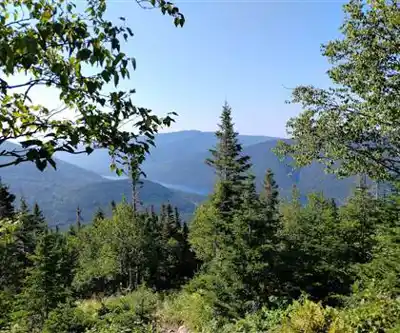
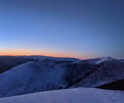
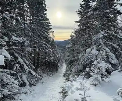
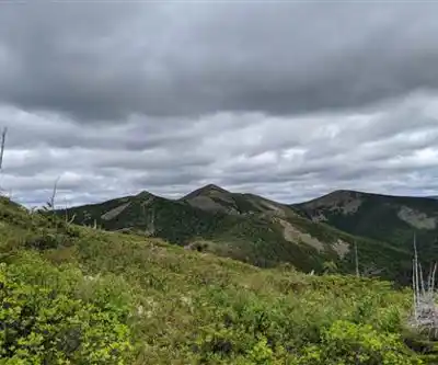
Photos: Yan Rioux — Google Maps (Google Maps) Phillip Schube-Coquereau — Google Maps (Google Maps) Daniel Turpin — Google Maps (Google Maps) Julien Dupras — Google Maps (Google Maps)
Available trails
| TrailTrails | Dist.Distance | GainElevation | TimeDuration | Difficulty | GPX |
|---|---|---|---|---|---|
|
|
2.14 km | — | 29min | GPX |
GPX track: © OpenStreetMap contributors — ODbL 1.0
Trail description
Mont Vallieres-de-Saint-Real delivers one of the most demanding climbs in the Gaspésie - Îles-de-la-Madeleine region. The numbers tell the story upfront: 8.5 km with 940 m of elevation gain, a hard difficulty rating, and an estimated 4 hours and 30 minutes on the trail. This is a mountain that asks something real of you, and it rewards that effort in kind.
The elevation profile makes the nature of the day clear before you even lace up your boots. You're not here for a casual forest walk — you're here to climb, and that sustained vertical challenge becomes the defining feature of the entire experience.
The ascent
The 940 m of elevation gain shapes every phase of this hike. The climb unfolds in natural stages that most hikers will recognize once they're moving. Early on, the forest feels close and sheltering, the grade is steady but manageable, and your legs are fresh enough that the effort feels controlled. This is the section where you set your pace — and setting it right matters more here than on most routes.
The middle section is where Mont Vallieres-de-Saint-Real earns its hard rating. The climbing becomes sustained and relentless, and the only way through it is to find a rhythm and hold it. Shorter steps, deliberate breathing, regular water breaks. The hikers who struggle on this mountain are usually the ones who pushed too hard early and have nothing left when the grade steepens.
As you gain height, the canopy begins to open. Wind picks up. The views start arriving in fragments — glimpses through the trees that hint at the broader landscape above. By the time you reach the upper elevations, the environment has shifted noticeably from where you started, and that transition is one of the more satisfying aspects of a climb like this.
Terrain and footing
The surface underfoot changes considerably over the course of the 8.5 km route. Lower sections tend to offer more predictable footing where you can settle into a consistent stride. Higher up, the terrain demands more attention — steeper pitches, less forgiving surfaces, and sections where you'll naturally reach for a handhold or use your hands for balance. Nothing technical, but nothing passive either.
Weather conditions can shift significantly between the trailhead and the upper mountain. Even on a calm, mild morning at the base, expect more wind and noticeably cooler temperatures as you gain elevation. During shoulder seasons, this difference becomes especially pronounced — comfortable at the bottom, genuinely cold at the top. Dress accordingly and don't leave your shell buried at the bottom of your pack.
Planning your day
The 4 hours and 30 minutes estimate assumes a solid hiking pace and reasonable comfort with sustained climbing. If you're newer to big elevation days, or if you prefer to move at a more relaxed tempo with longer breaks, add time to that estimate. There's no shame in taking five hours on a route with nearly a kilometer of vertical — what matters is finishing safely and enjoying the process.
Start early. An early departure gives you flexibility to adjust your pace, take proper rest breaks, and handle any weather changes without feeling rushed on the descent. Starting late compresses your options in ways that aren't worth the extra sleep.
Bring more water than you think you need. Sustained climbing increases your fluid requirements significantly, and the combination of exertion and changing temperatures means you'll be working your body hard for most of the outing. Drink regularly rather than waiting until you're thirsty.
Food strategy is worth thinking through. Keep snacks accessible — energy bars, trail mix, something that doesn't require stopping and unpacking your entire bag. Save a proper meal for a planned rest break where you can sit, refuel, and let your legs recover before the final push or the descent.
Who this hike is for
Mont Vallieres-de-Saint-Real is well suited to hikers who are ready for a genuine physical challenge and honest about their fitness level. You don't need to be an elite athlete, but you should have some experience with longer climbs and know how your body responds to sustained effort over several hours.
It's a strong choice for people training for bigger mountain objectives, hikers who find the meditative quality of a long climb appealing, or anyone who wants to test themselves against a significant vertical day in the Gaspésie. If you can pace yourself and you're comfortable spending most of your day moving uphill, the route is very achievable.
Less experienced hikers can attempt this, but it represents a meaningful step up from typical day hikes. If this is your first major climb, treat it conservatively — start early, carry extra supplies, and give yourself permission to turn back if the effort exceeds what you're prepared for that day.
Gear worth thinking about
Footwear matters on a route with this much elevation change. You want solid traction for both the ascent and the descent, plus enough support to keep your feet comfortable over the full distance. The sustained climbing will test whatever you're wearing, and the descent — often underestimated — puts its own demands on your ankles and knees.
A proper layering system is non-negotiable. Moisture-wicking base layer, an insulating mid-layer you can pull on and off easily, and a wind and rain shell for the exposed upper sections. Avoid cotton in any layer — it stays wet and cold the moment you stop moving, which happens frequently on a climb like this.
Trekking poles are worth considering if you use them regularly. On a sustained climb with 940 m of gain, they help with pacing on the way up and take meaningful stress off your knees on the way down.
The Gaspésie context
The Gaspésie - Îles-de-la-Madeleine region is known for dramatic landscapes where coastal and mountain environments meet, and Mont Vallieres-de-Saint-Real fits squarely into that tradition. The elevation gain carries you through multiple ecological zones — from the sheltered lower forest to the more exposed, windswept conditions typical of higher ground in the Gaspésie — giving you a compressed version of the environmental diversity that makes this region worth traveling to in the first place.
This is a mountain that asks for your full attention and gives back a full day's worth of experience in return.
The Essential Hiking Checklist
Everything you need for your next hike. Bilingual, printable, 1 page.
Get your free hiking checklistRecommended gear for this trail
As an Amazon Associate I earn from qualifying purchases.


Ready to go?
Everything you need to know before you goWhen?
How much?
As an Amazon Associate I earn from qualifying purchases.
Affiliate links — LGPO may earn a commission at no extra cost to you.
- Hiking shoes Essential
- → Salomon Elixir Tour Mid WP · 203.38 $
- Layered clothing Essential
- Rain jacket Essential
- Trekking poles
- → Black Diamond Trail Ergo Cork · 69.99 $
- Headlamp
- → Petzl Actik Core 625 · 103.95 $
FAQ - Frequently asked questions
Everything you need to knowSimilar hikes nearby
Discover other trails you might enjoy

Parc National De La Gaspésie
Gaspésie
Plage Haldimand
Gaspésie

Réserve Faunique De Matane
Gaspésie

Mont Saint-Pierre
Gaspésie

Parc National Du Canada Forillon
Gaspésie

Parc National De L'île-bonaventure-et-du-rocher-percé
Gaspésie
Hiking near Moncton
14 trails to explore ~320 km away
We work hard to provide the most up-to-date and error-free data possible. If something seems incorrect, let us know! Your contribution helps the whole community.
Hikers' opinions
Be the first to review!
No hiker has shared their experience yet. Share your impressions and help other hikers!