Hiking Belvédère Du Camping Sainte-véronique - panoramic view
--°C
Loading...
See forecast →

Hiking in Belvédère Du Camping Sainte-véronique: trails, map and practical info

Laurentides • Quebec

4.0 Appreciated by 27 hikers
François Dumaine
By François DumaineContributor since 2016Updated 20/05/2026
Difficulty
Easy
Distance
18 km
Elevation
100 m
Duration
5h30
Max altitude
100 m

This easy 17.5 km trail with 100 m elevation gain leads to stunning panoramic viewpoints in the heart of the Laurentides, Quebec. Well-maintained paths wind through lush forests to a spectacular belvédère offering sweeping vistas.

Recommended for :
Beginners

Ready to explore Belvédère Du Camping Sainte-véronique? Here's everything you need to know before you go!

Discover the trail

4 community photos

Available trails

Trails Distance Elevation Duration Difficulty GPX
1 km 15min Beginner
3.5 km 47min Beginner
6 km 1h30 Intermediate
7 km 1h30 Intermediate
Click a trail to see it on the map

Trail description

Description

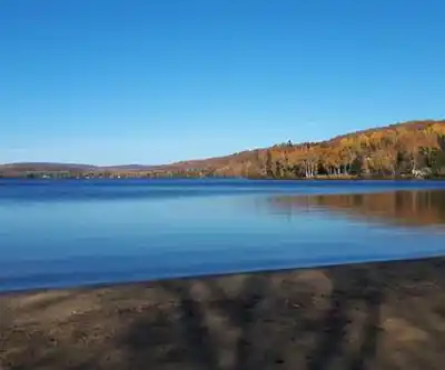
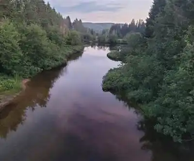
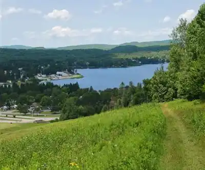
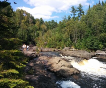
Belvédère Du Camping Sainte-Véronique is a quiet, rewarding hike in the Laurentides that’s all about getting out into the woods and finishing with a big, open view. It’s the kind of spot that feels like a “local secret” even though it’s straightforward to enjoy: a well-kept route through forested scenery, the steady soundtrack of nature, and a lookout where you can slow down and take in a wide panorama.

What makes this hike special

In a region known for its outdoor options, this belvédère stands out for its combination of calm surroundings and sweeping vistas. The setting is classic Laurentides: lush forests, fresh air, and a sense of being tucked into nature rather than on the edge of it. Along the way, you’re in habitat that supports vibrant wildlife, so even if you don’t spot animals directly, you’ll likely notice the signs and sounds—movement in the trees, birds calling, and the general feeling that you’re passing through a living landscape.

The payoff is at the top. Once you reach the viewpoint, the scenery opens up and the horizon feels far away. It’s a natural place to take a break, have a snack, and pull out your camera—this lookout is built for photos, but it’s just as good for sitting quietly and letting the view do the work.

Trail stats (what you’re committing to)

  • Distance: 17.5 km
  • Elevation gain: 100 m
  • Difficulty: Easy

With an easy rating and relatively modest elevation gain, this hike is approachable for a wide range of hikers, including people who are newer to longer distances. The length still makes it feel like a full outing, so it helps to plan like you’re going on a proper day hike even if the terrain doesn’t demand technical skills.

Trail experience: what it feels like on the ground

The route up to the belvédère is described as well-maintained and suitable for different skill levels. Expect a forest-first experience: shaded sections, a natural surface underfoot, and the kind of steady, easygoing progression that lets you focus on the surroundings rather than constant route-finding. The hike is less about steep climbs and more about moving through the landscape—breathing in that “mountain air” feeling the Laurentides are known for, and noticing the small details as you go.

Because the area is rich in flora and fauna, it’s worth slowing down occasionally and looking around. Even without a checklist of species, the variety shows itself in changes in vegetation, the density of the forest, and the way the sounds shift as you move. It’s a soothing hike by design: you’re trading traffic noise and everyday pace for the quieter rhythm of the woods.

The belvédère (viewpoint) and how to enjoy it

Reaching the top is the moment the hike pivots from “in the forest” to “above it.” The belvédère delivers panoramic views that stretch far into the distance, and it’s an ideal spot for taking photos—wide landscape shots, group pictures, or simply capturing the mood of the Laurentides from a higher vantage point.

If you’re visiting for the scenery, give yourself time here. The viewpoint is also where the calm of the hike really lands: it’s a place to pause, take a longer break than you normally would, and enjoy how still everything can feel when you’re away from the usual noise.

Who it’s good for

This is an especially good choice if you want a hike that feels scenic without demanding expert fitness or technical footing. The maintained trails and easy rating make it friendly for a broad range of hikers, from experienced walkers looking for a mellow day to people building confidence on longer outings. If you’re hiking with someone who appreciates nature more than big climbs, this trail fits nicely—there’s plenty to enjoy in the forest on the way up, and a clear “destination moment” at the belvédère.

Camping and extending your visit

One of the most practical perks of this hike is how naturally it pairs with an overnight stay. Camping Sainte-Véronique offers solid facilities for campers, so you can turn the hike into a full weekend outdoors instead of a single outing. Whether you like the simplicity of pitching a tent under the stars or prefer the convenience of an RV, you can set yourself up comfortably and keep the focus on being outside.

This also makes the experience more flexible: you can hike when the timing feels right, linger at the viewpoint without watching the clock, and then settle in at camp rather than rushing back to “real life” immediately.

Planning notes for a smooth day

Even with an easy rating, 17.5 km is long enough that a little preparation goes a long way. Wear comfortable hiking footwear, bring a camera if you enjoy taking photos, and plan your day so you have time to enjoy the belvédère without feeling hurried. The overall experience here is about soaking in the scenery—lush forests on the approach, wildlife presence in the background, and that wide-open view at the top—so it’s worth pacing yourself and treating it like the outdoors escape it’s meant to be.

Services and amenities

Parking Icon Parking
Reception Icon Reception
Toilet Icon Toilet
Belvedere Icon Belvedere
Refuge

This information may vary by season.

Ready to go?

Everything you need to know before you go

Where?

Address
320 Ch du Tour du Lac Tibériade, Rivière-Rouge, QC J0T 1T0, Canada
GPS coordinates
46.5114422, -74.9858113
Phone
(819) 275-2155

Starting Point

To access the hiking trails, head to the parking lot located at 1000 Chemin de la Montagne, Sainte-Véronique, Quebec. This is the primary starting point for the trails in the area.

When?

Opening hours
No information
Varies by season
Best season
Fall
Spectacular colors
Best time
Early morning
Less crowded
Weather (next days)
Loading

How much?

Entry fees
Adult
$ 5.75
Child
What to bring?
Gear
  • Hiking shoes Essential
  • Layered clothing Essential
  • Rain jacket Essential
  • Trekking poles
  • Headlamp
Download the PDF checklist
Water & food
2L minimum
No water point on the trail
Bring energy snacks for a 4h+ hike
Good to know
Park rules
No dogs
Safety
Download the GPX before you go
Limited cellular coverage on the trail
Slippery after rain
Be careful on rocky sections
In an emergency
Emergency
911
Parking GPS
46.5114422, -74.9858113
Center
(819) 275-2155

Hikers' opinions

4.0
8 Reviews
R4
Review 4
Mar 10, 2024
You loved it and so will others! This scenic trail offers an excellent introduction to Laurentides hiking with its manageable 100m elevation gain over 17.5km. The belvedere at Camping Sainte-Véronique delivers spectacular views. Good infrastructure with parking, toilets, and a reception pavilion makes logistics easy despite the entry fees.
R3
Review 3
Feb 22, 2024
Superb experience on this easy-rated trail in the beautiful Laurentides region. The belvedere viewpoint is absolutely breathtaking and justifies the entire 17.5km journey. Well-organized with good parking facilities at 1000 Chemin de la Montagne, plus the refuge provides a nice rest stop. Highly recommend for a full day adventure.
R2
Review 2
Feb 8, 2024
Pretty cool place. You will love for sure! :-) The belvedere provides amazing panoramic views after the gentle 100m elevation gain. The reception pavilion staff are helpful with trail information, and having proper facilities like toilets makes the 17.5km hike much more comfortable. Worth every penny despite the access fees!
R1
Review 1
Jan 15, 2024
Very good place. The 17.5km trail through the Laurentides offers stunning views from the belvedere at Camping Sainte-Véronique. Despite the parking fees, the easy difficulty level makes it accessible for most hikers. The refuge and toilet facilities along the route are well-maintained and convenient for the longer journey.
LC
Lydia Crawford
Oct 18, 2015
Very good place.

FAQ - Frequently asked questions

Everything you need to know
Easy
100.00 M
100.00 M
5h30
No
5.75 $
Yes
The Belvédère Du Camping Sainte-véronique trail is rated as Easy difficulty. With only 100 meters of elevation gain over 17.5 km, it's suitable for hikers of various skill levels.
The Belvédère Du Camping Sainte-véronique trail covers a distance of 17.5 kilometers. The relatively flat terrain with minimal elevation gain makes it a longer but manageable hike.
No, dogs are not allowed on the Belvédère Du Camping Sainte-véronique trail. Plan to leave your pets at home when visiting this hiking area.
Yes, the Belvédère Du Camping Sainte-véronique trail is suitable for beginners and families due to its Easy difficulty rating. The minimal elevation gain of 100 meters makes it accessible for less experienced hikers.
The trail offers several facilities including parking, a reception pavilion, toilets, a belvedere viewpoint, and refuge accommodations. Note that both parking and trail access require fees.
Didn't find your answer?
Free 1 pages

The Essential Hiking Checklist

Everything you need for your next hike. Bilingual, printable, 1 page.

Download the free checklist
Top 10 best hiking in Laurentides
Our ranking based on hiker reviews

Hiking near Gatineau

48 trails to explore ~128 km away

View trails
Did you spot an error?

We work hard to provide the most up-to-date and error-free data possible. If something seems incorrect, let us know!

Update : June 2026