

Ready to explore Centre D'interprétation De La Nature Et Sentier Des Berges De Boisbriand? Here's everything you need to know before you go!
Discover the trail


Available trails
| Trails | Distance | Elevation | Duration | Difficulty | GPX |
|---|---|---|---|---|---|
| 1.1 km | 0 m | 15min | Beginner | ||
| 2 km | 0 m | 27min | Beginner |
Trail description
Description
The Centre D'interprétation De La Nature Et Sentier Des Berges De Boisbriand offers a perfect blend of education and outdoor exploration in the Laurentides. This 3.1-kilometer trail combines an interpretive nature center with an easy riverside walk that takes about an hour to complete. Located just a short drive from Montreal, it's an accessible escape that works equally well for families looking for an educational outing, solo hikers seeking a peaceful walk, or anyone wanting to connect with nature without venturing too far from the city.
What makes this place special
This isn't just another walking trail—it's a complete nature experience that starts before you even hit the path. The Centre D'interprétation De La Nature serves as your gateway to understanding the local ecosystem, with engaging exhibits and knowledgeable staff who can help you identify what you'll see along the riverbank. This educational component transforms a simple walk into a discovery experience, making every bird call, plant, and water feature more meaningful.
The proximity to Montreal makes it particularly valuable as a quick nature fix. You can drive out, learn something new, take a relaxing walk along the water, and be back in the city within a few hours. It's the kind of place that proves you don't need to travel far to find genuine outdoor experiences.
The trail experience
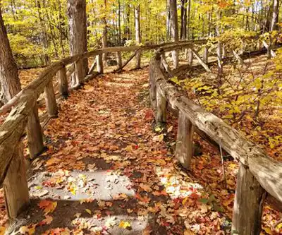
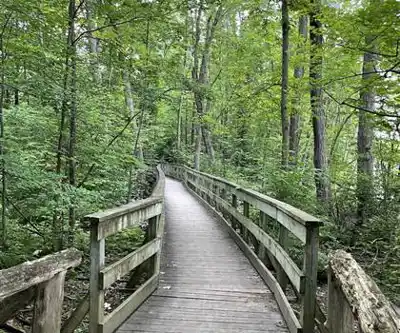
The Sentier Des Berges de Boisbriand follows the natural curves of the riverbank, creating a gentle, meandering route that prioritizes scenery over physical challenge. With only 10 meters of elevation gain, this is truly an easy walk that lets you focus on your surroundings rather than your breathing. The trail is well-maintained and clearly marked, which means you can relax and enjoy the experience without worrying about navigation.
As you walk, the river remains your constant companion, providing both visual interest and a calming soundtrack. The path winds along the shoreline, revealing new perspectives around each bend. This isn't a destination hike where you're pushing toward a summit or waterfall—instead, the journey itself is the reward, with the best moments often coming when you pause to watch the water or scan the trees for wildlife.
Terrain and what to expect
The riverside setting creates a unique microenvironment that supports diverse plant and animal life. You'll walk through areas where the forest meets the water, creating habitat edges that are particularly rich in biodiversity. The peaceful surroundings make it easy to spot birds, and the open water views provide excellent opportunities for photography.
The trail surface is well-suited to regular walking shoes, and the gentle terrain makes it accessible to hikers of all experience levels. Families with children will appreciate the straightforward route and the interpretive elements that keep young minds engaged. The clear markings mean you can focus on what you're seeing rather than where you're going.
Learning opportunities along the way
One of the trail's strongest features is its educational component. Interpretive signs are strategically placed along the route, providing information about the area's ecosystems and wildlife. These signs help you understand the relationships between the river, the surrounding forest, and the animals that call this area home.
The trail offers excellent birdwatching opportunities, particularly for species that thrive in riverside habitats. Bring binoculars if you have them—the combination of water, trees, and open areas creates ideal conditions for spotting various bird species throughout the seasons. The interpretive center can help you identify what you're likely to see and when.
For photography enthusiasts, the changing perspectives along the riverbank provide numerous opportunities to capture both wide landscape shots and detailed nature photography. The relatively easy terrain means you can take your time setting up shots without worrying about difficult footing or time pressure.
Who will enjoy this trail
This trail works for an unusually broad range of visitors. Experienced hikers will appreciate it as a low-key option when they want fresh air and nature without a serious physical workout. Beginning hikers will find it approachable and confidence-building, with clear paths and manageable distances that let them focus on enjoying the outdoors.
Families will find the combination of education and easy hiking particularly appealing. The interpretive center gives kids something concrete to learn about, while the trail provides a chance to see those lessons in action. The gentle terrain and short distance work well for younger hikers, and the interpretive signs along the way help maintain interest throughout the walk.
Solo visitors seeking solitude will appreciate the peaceful atmosphere and the opportunity to move at their own pace. The riverside setting naturally encourages a slower, more contemplative approach to hiking.
Making the most of your visit
Plan to spend some time at the Centre D'interprétation De La Nature either before or after your walk. The exhibits provide valuable context that enhances your trail experience, and the staff can offer current information about wildlife activity and seasonal highlights. This preparation helps you notice details you might otherwise miss.
The designated picnic areas make it easy to extend your visit beyond just the walk. Pack a lunch and plan to eat outdoors—the natural setting makes even a simple meal feel special. The peaceful atmosphere and water views create an ideal environment for a relaxed outdoor meal.
Remember to pack out what you pack in to help maintain the area's natural beauty. Bringing a small bag for trash ensures you can enjoy your picnic while leaving the area pristine for other visitors.
Practical considerations
This is a straightforward outing that doesn't require specialized gear. Comfortable walking shoes, water, and weather-appropriate clothing are all you need for the trail itself. If you're interested in birdwatching, binoculars will significantly enhance your experience. A camera is worth bringing for the scenic river views and potential wildlife sightings.
The trail's easy difficulty and short duration make it perfect for spontaneous outings when you have a few hours free and want to get outside. The proximity to Montreal means you can easily fit it into a day that includes other activities, or use it as a peaceful way to start or end a weekend.
Whether you're drawn by the educational opportunities at the interpretive center, the peaceful riverside walk, or the chance to observe local wildlife, the Centre D'interprétation De La Nature Et Sentier Des Berges De Boisbriand delivers a well-rounded outdoor experience that proves nature education and recreation work beautifully together.
Services and amenities
This information may vary by season.
Recommended gear for this trail


Ready to go?
Everything you need to know before you goStarting Point
To access the hiking trails, head to the main trailhead located at 480 Rue de Chavigny, Boisbriand, QC J7G 2N6. This is where you can find parking and begin your hike.
When?
Tuesday: 7:00 AM – 9:00 PM
Wednesday: 7:00 AM – 9:00 PM
Thursday: 7:00 AM – 9:00 PM
Friday: 7:00 AM – 9:00 PM
Saturday: 7:00 AM – 9:00 PM
Sunday: 7:00 AM – 9:00 PM
How much?
- Hiking shoes Essential
- → Salomon Elixir Tour Mid WP · 203.38 $
- Layered clothing Essential
- Rain jacket Essential
- Trekking poles
- → Black Diamond Trail Ergo Cork · 69.99 $
- Headlamp
- → Petzl Actik Core 625 · 103.95 $
FAQ - Frequently asked questions
Everything you need to knowTuesday: 7:00 AM – 9:00 PM
Wednesday: 7:00 AM – 9:00 PM
Thursday: 7:00 AM – 9:00 PM
Friday: 7:00 AM – 9:00 PM
Saturday: 7:00 AM – 9:00 PM
Sunday: 7:00 AM – 9:00 PM
The Essential Hiking Checklist
Everything you need for your next hike. Bilingual, printable, 1 page.
Download the free checklistSimilar hikes nearby
Discover other trails you might enjoy
Parc De La Rivière Doncaster
Laurentides

Parc Du Domaine Vert
Laurentides

Parc national d'Oka
Laurentides

Sommet Saint-Sauveur
Laurentides

Mont Condor
Laurentides

Montagne Du Dépôt Et Montagne Du Caribou
Laurentides
Hiking near Laval
97 trails to explore ~9 km away
We work hard to provide the most up-to-date and error-free data possible. If something seems incorrect, let us know! Your contribution helps the whole community.
Hikers' opinions