

Ready to explore Le Nid De L'aigle Et Le Mont Larose? Here's everything you need to know before you go!
Discover the trail
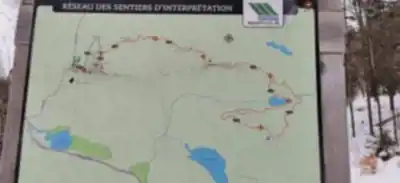


Available trails
| Trails | Distance | Elevation | Duration | Difficulty | GPX |
|---|---|---|---|---|---|
| 3.9 km | 0 m | 52min | Intermediate | ||
| 2.8 km | 200 m | 56min | Intermediate | ||
| 5.1 km | 0 m | 1h | Intermediate |
Trail description
Description
Le Nid De L'aigle et Mont Larose (Laurentides)
In the Laurentides, Le Nid De L'aigle and Mont Larose make a rewarding pair of hikes for anyone looking to spend a few hours moving through forest and finishing with views. The area has that classic Laurentides feel—wooded trails, fresh air, and a calm, back-to-nature atmosphere that works whether you’re hiking for a workout, a quiet reset, or a day outside with friends.
If you’re planning your outing as one linked adventure, the route is listed at 6.4 km with about 300 m of elevation gain. Most hikers will want to budget roughly 3h00 for the outing, depending on how long you linger at viewpoints or picnic spots.
Le Nid De L'aigle: viewpoints worthy of the name
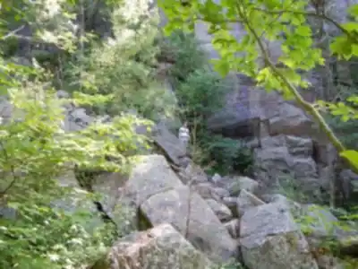
Le Nid De L'aigle—“The Eagle’s Nest”—is the one you’ll remember for the lookout moments. The climb is described as moderately challenging, which feels accurate for hikers who want a bit of effort without turning the day into an all-out grind. Expect the kind of steady ascent that gets your breathing up, especially as you gain height, with the forest doing a good job of making the climb feel immersive rather than exposed.
As you work your way upward, you’ll be surrounded by lush forest and the small details that make a Laurentides hike feel alive: the rustling of leaves, the shifting light as the canopy opens and closes, and the quiet that settles in once you’re away from the trailhead. It’s the sort of trail where the scenery builds gradually, so the viewpoint payoff feels earned.
At the summit, the draw is the panoramic view. The lookout is described as offering sweeping views that stretch as far as the eye can see, making it an obvious place to take a break. Bring a layer you can throw on when you stop—after a climb, it’s easy to cool down quickly once you’re standing still. And keep your eyes on the sky: it’s specifically noted as a place where you might spot an eagle soaring high above, which is exactly the kind of wildlife moment that turns a viewpoint into a memory.
Mont Larose: varied terrain and biodiversity along the way
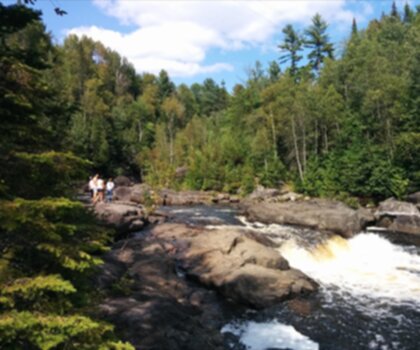
Mont Larose sits just a stone’s throw away, and it’s a good contrast to Le Nid De L'aigle. Where the Eagle’s Nest is all about earning a big vantage point, Mont Larose is described as a walk through the region’s living textures—diverse terrain and rich biodiversity that highlights what makes the Laurentides special.
On this trail, the experience comes from what you pass through, not just where you end up. You’ll be moving among a mix of natural features that support a range of plant and animal life, with flora and fauna unique to the Laurentides region. If you enjoy noticing the details—different plant communities, the way the forest changes with subtle shifts in elevation, and the signs of wildlife—this is the section that tends to reward a slower pace.
From a planning standpoint, Mont Larose is described as well-marked and suitable for hikers of all levels. That’s useful if you’re bringing a group with mixed experience or kids who do better when the route is straightforward to follow. It’s also noted as an ideal choice for families or groups with varying abilities, so it’s a solid pick when you want the outing to feel accessible without stripping away the sense of being out in real nature.
Along the way, you’ll come across serene spots that work well for a break. The trail specifically mentions places that are perfect for picnicking or simply sitting down to soak in the quiet. If a picnic is part of your plan, pack food that’s easy to eat trailside and bring a small bag so everything you bring in comes back out with you.
What the hike feels like overall
Together, Le Nid De L'aigle and Mont Larose offer a balanced half-day outdoors: a moderate challenge with enough elevation to feel satisfying, plus sections that emphasize nature study and relaxed pacing. You’ll spend most of your time in forest, with the highlight moments coming when the trees open up and the landscape stretches out below you.
This is a good option when you want variety without needing technical skills: one part focused on climbing to a viewpoint, the other on moving through changing terrain with plenty of natural interest. For hikers who like a clear goal, the summit views at Le Nid De L'aigle keep you motivated. For hikers who prefer wandering and noticing, Mont Larose adds that “journey through nature” feel the description points to.
Practical tips to plan your day
- Plan ahead: Check weather conditions before you go and make sure you have appropriate gear. A moderate climb can feel very different depending on heat, rain, or wind at the summit.
- Stay hydrated: Bring plenty of water, especially in warmer months. Even a 3-hour outing can sneak up on you if you’re climbing and stopping for photos.
- Respect nature: Stick to the marked trails and pack out any trash you bring in. Staying on-trail also helps protect the plants and habitats that make Mont Larose’s biodiversity stand out.
- Capture memories: Bring a camera or smartphone for the panoramic viewpoints and any wildlife you’re lucky enough to see—especially if an eagle does make an appearance overhead.
Whether you’re coming for solitude and forest quiet or sharing the day with friends or family, these Laurentides trails give you a mix of exercise, viewpoints, and easy-to-follow hiking with plenty of natural beauty along the way.
Services and amenities
This information may vary by season.
Recommended gear for this trail


Ready to go?
Everything you need to know before you goStarting Point
The Mont Larose trailhead is located in Saint-Sauveur, in the Laurentian region. To get there, take Highway 15 North and exit at Exit 66. Then take route 158 East and continue to Saint-Sauveur. The trailhead is on the right, after the bridge.
When?
How much?
- Hiking shoes Essential
- → Salomon Elixir Tour Mid WP · 203.38 $
- Layered clothing Essential
- Rain jacket Essential
- Trekking poles
- → Black Diamond Trail Ergo Cork · 69.99 $
- Headlamp
- → Petzl Actik Core 625 · 103.95 $
FAQ - Frequently asked questions
Everything you need to knowThe Essential Hiking Checklist
Everything you need for your next hike. Bilingual, printable, 1 page.
Download the free checklistSimilar hikes nearby
Discover other trails you might enjoy
Parc De La Rivière Doncaster
Laurentides

Parc Du Domaine Vert
Laurentides

Parc national d'Oka
Laurentides

Sommet Saint-Sauveur
Laurentides

Mont Condor
Laurentides

Montagne Du Dépôt Et Montagne Du Caribou
Laurentides
Hiking near Laval
97 trails to explore ~74 km away
We work hard to provide the most up-to-date and error-free data possible. If something seems incorrect, let us know! Your contribution helps the whole community.
Hikers' opinions