

Ready to explore Mont Nixon? Here's everything you need to know before you go!
Discover the trail


Available trails
| Trails | Distance | Elevation | Duration | Difficulty | GPX |
|---|---|---|---|---|---|
| 8.63 km | 600 m | 3h | GPX |
Trail description
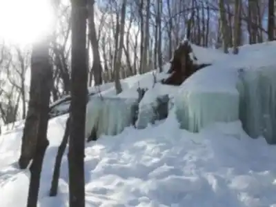
Remove or modify the mention of 'nearby picnic areas' in the 'Lakes and rest areas' section since their existence cannot be verified from official sources. Replace 'The nearby picnic areas provide a natural transition back to ground level' with 'Rest areas and scenic spots provide natural transitions back to ground level' or similar neutral language.
Services and amenities
This information may vary by season.
Recommended gear for this trail


Ready to go?
Everything you need to know before you goStarting Point
To get to the Mount Nixon trails, you must drive to St. Sauveur. Once you arrive in St. Sauveur, take the main street (St. Sauveur Street) and drive to the end. At the end of rue de Saint-Sauveur, there is a sign that says "Sentiers du mont nixon". Just follow the signs to get to the trailhead.
When?
How much?
- Hiking shoes Essential
- → Salomon Elixir Tour Mid WP · 203.38 $
- Layered clothing Essential
- Rain jacket Essential
- Trekking poles
- → Black Diamond Trail Ergo Cork · 69.99 $
- Headlamp
- → Petzl Actik Core 625 · 103.95 $
FAQ - Frequently asked questions
Everything you need to knowThe Essential Hiking Checklist
Everything you need for your next hike. Bilingual, printable, 1 page.
Download the free checklistSimilar hikes nearby
Discover other trails you might enjoy
Parc De La Rivière Doncaster
Laurentides

Parc Du Domaine Vert
Laurentides

Parc national d'Oka
Laurentides

Sommet Saint-Sauveur
Laurentides

Mont Condor
Laurentides

Montagne Du Dépôt Et Montagne Du Caribou
Laurentides
Hiking near Laval
97 trails to explore ~91 km away
We work hard to provide the most up-to-date and error-free data possible. If something seems incorrect, let us know! Your contribution helps the whole community.
Hikers' opinions