

Ready to explore Parc Du Corridor Aérobique? Here's everything you need to know before you go!
Discover the trail


Available trails
| Trails | Distance | Elevation | Duration | Difficulty | GPX |
|---|---|---|---|---|---|
| 58 km | 0 m | 13h | Intermediate |
Trail description
Description
Parc Du Corridor Aérobique is a quiet, low-stress way to get out into the Laurentides and actually spend time in the landscape, not just rush through it. It’s built around a long, linear trail that feels more like a journey than a single out-and-back hike, with forests, lakes, and rolling hills unfolding as you go.
An old railway line turned long trail
The main feature here is a 58-kilometer trail that follows an old railway line. That history matters on foot: former rail corridors tend to create a steady, predictable route, and this one links communities as it goes. The corridor connects Morin-Heights to Saint-Rémi-d'Amherst, so even if you only walk a section, you’re still traveling along a continuous line with a clear sense of direction and place.
Because it’s a rail-trail, the experience is less about scrambling over obstacles and more about settling into a rhythm. Expect long, straight stretches mixed with gentle curves where the route threads through the Laurentides’ classic scenery—lush forests, serene lakes, and rolling hills. You’ll also pass near or through charming villages, which helps break up the day and gives the hike a “point A to point B” feeling rather than a loop that starts and ends at the same parking spot.
Terrain and difficulty: approachable, steady walking
This is a good choice if you want a hike that’s straightforward to follow and not overly demanding. The trail is described as well-maintained and relatively flat, which makes it a solid option for a wide range of hikers, including people who are newer to longer walks or who just want a calmer day outside.
Even on an easier, flatter trail, the distance can add up quickly, so it helps to think in terms of sections. You can commit to the entire corridor over multiple days, or you can pick shorter stretches that match your energy level and daylight. The benefit of a long, connected corridor is flexibility: you can build a short walk around the time you have, or you can plan a longer day where the goal is simply to cover ground and enjoy the scenery as it changes.
What you’ll actually see along the way
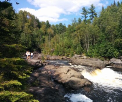
One of the standout parts of hiking Parc Du Corridor Aérobique is how consistently “Laurentides” it feels. As you move along the corridor, the backdrop shifts between dense forest and more open views where you get a sense of the region’s gentle relief—those rolling hills that make the landscape feel layered without being mountainous.
The trail also takes you past serene lakes, the kind of calm water views that are easy to linger at. This isn’t a single viewpoint hike where everything builds to one summit; instead, it’s a series of smaller, quieter moments—light filtering through trees, short openings toward water, and the steady sense of traveling through a large, connected natural area.
Because the route follows a former rail line, the grade stays manageable, and that lets you pay attention to what’s around you: the texture of the forest, the way the corridor cuts through different types of vegetation, and the small changes in scenery as you approach different communities along the route.
Wildlife watching (and what to look for)
It’s worth keeping your eyes up and scanning the edges of the trail as you walk. The Laurentides are home to a variety of wildlife, and along this corridor you may spot deer or foxes, especially in quieter sections away from villages. There are also various bird species throughout the area, so even if larger mammals stay hidden, you’ll likely hear and see plenty of bird activity along forested stretches and near water.
If wildlife viewing is part of your goal, move at an easy pace and take advantage of natural pauses—those moments when you stop for a drink or a snack are often when animals feel comfortable enough to appear. Staying attentive near lakes and along forest edges can be especially rewarding.
Seasonal feel: the same corridor, four different experiences
This trail changes character with the seasons, which makes it a good repeat visit if you live within reach of the Laurentides. In fall, you’ll get vibrant foliage as the forests shift color around the corridor. In winter, the route becomes a quieter, more hushed experience with snow-covered trails and a different kind of scenery as the landscape simplifies into whites, dark evergreens, and open sightlines.
Spring brings blooming wildflowers and a fresh feel as the forest wakes up, while summer is all about lush greenery, fuller tree cover, and longer days that make it easier to plan a longer section without rushing. If you’re choosing when to go, think about the kind of atmosphere you want: color and crisp air in fall, quiet and snow in winter, new growth in spring, or deep green forest in summer.
How to plan your day on the corridor
A little planning goes a long way on a long, linear trail. Before you go, check local weather conditions so you can match your clothing and layers to the day. Even an easy, flatter route can feel tougher if you’re underdressed in cold weather or overheating in warm conditions.
Bring the basics that make a long walk feel comfortable: plenty of water and snacks you’ll actually eat when you’re moving steadily for hours. A camera is worth packing too—this corridor offers lots of small scenic moments rather than one single must-photograph viewpoint, so having a camera handy lets you capture lakeside stops, seasonal colors, and those stretches where the rolling hills frame the trail.
One practical advantage here is that there are several access points along the trail. That means you can start where it makes sense for your schedule and route, and you can also plan a shorter hike without committing to the entire distance. If you’re new to longer hikes, picking an access point and doing an out-and-back section is a simple way to get a feel for the trail without worrying about logistics.
Pacing and break spots
Along the corridor, you’ll find plenty of spots to rest and take in the views. Use those pauses intentionally. On a flatter trail, it’s easy to keep walking longer than you planned because it doesn’t feel difficult early on; steady breaks help you manage energy and enjoy the scenery instead of focusing only on distance.
If you’re walking a shorter section, consider setting a turnaround point at a lake view or another scenic stretch so your “destination” feels meaningful. If you’re tackling longer segments, break the day into manageable chunks—walk steadily, stop when you find a good resting place, refuel, and then continue. That approach fits the character of Parc Du Corridor Aérobique: a relaxed, scenic corridor where the journey itself is the main experience.
Services and amenities
This information may vary by season.
Recommended gear for this trail


Ready to go?
Everything you need to know before you goStarting Point
The trailhead for parc du corridor aérobique is located in Saint-Sauveur, in the Laurentian region. To get there, take Highway 15 North and exit at Exit 66. Then take route 117 East and continue to Saint-Sauveur. The trailhead is on the right, after the bridge over the Diable River.
When?
How much?
- Hiking shoes Essential
- → Salomon Elixir Tour Mid WP · 203.38 $
- Layered clothing Essential
- Rain jacket Essential
- Trekking poles
- → Black Diamond Trail Ergo Cork · 69.99 $
- Headlamp
- → Petzl Actik Core 625 · 103.95 $
FAQ - Frequently asked questions
Everything you need to knowThe Essential Hiking Checklist
Everything you need for your next hike. Bilingual, printable, 1 page.
Download the free checklistSimilar hikes nearby
Discover other trails you might enjoy
Parc De La Rivière Doncaster
Laurentides

Parc Du Domaine Vert
Laurentides

Parc national d'Oka
Laurentides

Sommet Saint-Sauveur
Laurentides

Mont Condor
Laurentides

Montagne Du Dépôt Et Montagne Du Caribou
Laurentides
Hiking near Laval
97 trails to explore ~53 km away
We work hard to provide the most up-to-date and error-free data possible. If something seems incorrect, let us know! Your contribution helps the whole community.
Hikers' opinions