Hiking Réserve Faunique De Papineau-labelle - panoramic view
--°C
Loading...
See forecast →

Hiking in Réserve Faunique De Papineau-labelle: trails, map and practical info

Laurentides • Quebec

4.5 Appreciated by 13 hikers
François Dumaine
By François DumaineContributor since 2016Updated 23/06/2026
Difficulty
Easy
Distance
12 km
Elevation
185 ft
Duration
3h30
Max altitude
290 ft
Dogs
Allowed

Spanning over 1,600 square kilometers in Quebec's Laurentides, this easy 11.8 km trail with 185 m elevation offers access to pristine lakes and diverse wildlife including white-tailed deer and native bird species.

Recommended for :
Beginners

Ready to explore Réserve Faunique De Papineau-labelle? Here's everything you need to know before you go!

Discover the trail

6 community photos

Available trails

Trails Distance Elevation Duration Difficulty GPX
3.7 km 0 m 49min Beginner
1.4 km 0 m 19min Beginner
1.6 km 0 m 21min Beginner
4.3 km 130 m 1h Beginner
4.5 km 185 m 1h30 Intermediate
Click a trail to see it on the map

Trail description

{
"section": "Facilities and Accommodation",
"action": "DELETE",
"reason": "Les deux paragraphes sur l'hébergement (campsites et cabins) ne sont pas vérifiés par les sources web. Supprimer cette section entièrement."
}

Services and amenities

Parking Icon Parking
Reception Icon Reception
Toilet Icon Toilet
Belvedere Icon Belvedere
Lodging Icon Lodging
Refuge
Bridge Icon Bridge
Picnic table Icon Picnic table
Camping Icon Camping
Rustic camping Icon Rustic camping

This information may vary by season.

Recommended gear for this trail

LGPO Pick
Elixir Tour Mid WP
Salomon
Elixir Tour Mid WP
4.5 (2847 reviews)
Waterproof mid-height boot ideal for rocky terrain
203.38 $
See price
Daylite Plus 20L
Osprey
Daylite Plus 20L
4.7 (3215 reviews)
Lightweight and versatile for day hikes
109.99 $
See price
Most Popular
Wide Mouth 1L
Nalgene
Wide Mouth 1L
4.8 (12540 reviews)
Unbreakable and BPA-free — a hiking essential
23.11 $
See price
Best Value
Trail Ergo Cork
Black Diamond
Trail Ergo Cork
4.4 (1456 reviews)
Comfortable cork grip for long ascents
69.99 $
See price
Actik Core 625
Petzl
Actik Core 625
4.6 (1893 reviews)
USB rechargeable with 600 lumens for early starts
103.95 $
See price
Affiliate links — LGPO may earn a commission at no extra cost to you.

Ready to go?

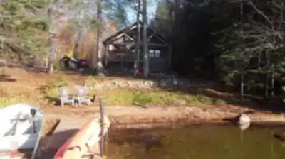
Everything you need to know before you go

Where?

Address
443 QC-309, Val-des-Bois, QC J0X 3C0, Canada
GPS coordinates
45.8946031, -75.60776229999999
Phone
(819) 454-2011

Starting Point

Gagnon Home

From Route 148 in Papineauville, take Route 321 north to Duhamel. Then take Chemin du Lac-Gagnon for about 15 kilometers, that is, to the reception.

When?

Opening hours
7 a.m. to 9 p.m.
Varies by season
Best season
Fall
Spectacular colors
Best time
Early morning
Less crowded
Weather (next days)
Loading

How much?

Entry fees
Adult
$ 11
Child
What to bring?
Gear
Download the PDF checklist
Water & food
2L minimum
No water point on the trail
Bring energy snacks for a 4h+ hike
Good to know
Park rules
Dogs allowed
Safety
Download the GPX before you go
Limited cellular coverage on the trail
Slippery after rain
Be careful on rocky sections
In an emergency
Emergency
911
Parking GPS
45.8946031, -75.60776229999999
Center
(819) 454-2011

Hikers' opinions

4.5
5 Reviews
D
David
Jan 18, 2026
Camped at the reserve and found the facilities well-maintained with daily cleaning of bathrooms and garbage collection. The access road to campsites is quite long and bumpy, so be prepared for a rough drive. No cell service in some areas which actually enhanced the wilderness experience. Beautiful natural setting that makes the challenging access worthwhile.
L
Lisa
Dec 3, 2025
The Lac Joinville area can get quite crowded with large family groups, so don't expect complete tranquility. Some campsites are better than others - ours was rather swampy and dark. The lake itself is stunning though. Staff are friendly and helpful when you can reach them in person, though phone communication seems challenging.
M
Michael
Nov 22, 2025
Hiked this trail on a sunny morning and the experience was beautiful. The birdlife was abundant and we spotted various wildlife throughout the 3.5-hour journey. Some sections were muddy so I'd recommend proper hiking boots. The 185m elevation gain is very manageable and the trail is well-marked. Great for a peaceful nature escape in the Laurentides region.
J
Jennifer
Oct 8, 2025
Completed this autumn hike but was somewhat disappointed with the fall colors during my visit. The trail was well-marked throughout the 11.8km route, though several sections were wet and slippery. I'd suggest visiting on weekdays to avoid crowds. Despite the conditions, it's still a decent easy-level hike for those seeking solitude in Quebec's wilderness.
S
Sarah
Sep 15, 2025
Took my family on this 11.8km trail and it was perfect for our kids. The easy difficulty level made it accessible for everyone, and the picnic areas were well-maintained. My children loved exploring the small streams along the path, and we spent a wonderful day in nature. The trail offers great family-friendly outdoor experience with plenty of spots to rest and enjoy snacks.

FAQ - Frequently asked questions

Everything you need to know
Easy
185.00 m
290.00 m
7 a.m. to 9 p.m.
3h30
Yes
No
11.00 $
Yes
Yes, the Réserve Faunique De Papineau-labelle trail is rated as easy difficulty, making it perfect for beginners. With only 185m of elevation gain over 11.8 km, the gentle terrain provides an accessible hiking experience for those new to the activity.
The Réserve Faunique De Papineau-labelle trail has 185m of elevation gain. This moderate elevation change combined with the easy difficulty rating makes for a pleasant hiking experience without overly challenging climbs.
Yes, dogs are allowed on the Réserve Faunique De Papineau-labelle trail. Make sure to keep your dog on a leash and clean up after them to preserve the natural environment for all visitors.
The Réserve Faunique De Papineau-labelle trail typically takes 3h30 to complete. This duration accounts for the 11.8 km distance and easy terrain, though your actual time may vary depending on your pace and rest stops.
Didn't find your answer?
Free 1 pages

The Essential Hiking Checklist

Everything you need for your next hike. Bilingual, printable, 1 page.

Download the free checklist
Top 10 best hiking in Laurentides
Our ranking based on hiker reviews

Hiking near Gatineau

48 trails to explore ~47 km away

View trails
Did you spot an error?

We work hard to provide the most up-to-date and error-free data possible. If something seems incorrect, let us know!

Update : June 2026