

Ready to explore Sentiers Accès-nature Laurentides? Here's everything you need to know before you go!
Discover the trail
Available trails
| Trails | Distance | Elevation | Duration | Difficulty | GPX |
|---|---|---|---|---|---|
| 3.2 km | 80 m | 50min | Beginner | ||
| 2.4 km | 45 m | 36min | Beginner | ||
| 4.4 km | 50 m | 1h | Beginner | ||
| 4.4 km | 59min | Beginner | |||
| 3.1 km | 41min | Beginner | |||
| 7 km | 100 m | 2h | Intermediate | ||
| 4.5 km | 280 m | 1h30 | Intermediate | ||
| 4.4 km | 145 m | 1h30 | Intermediate |
Trail description
Description
Sentiers Accès-nature Laurentides is a lesser-known trail network tucked into the Laurentides region, and it’s the kind of place that feels like a real break from the city without requiring a big expedition. It’s close enough to Montreal for a day trip, but once you step onto the trails, you’re quickly surrounded by forest and calm, with the noise of the road replaced by wind in the trees and the sound of water nearby.
What the hike is like
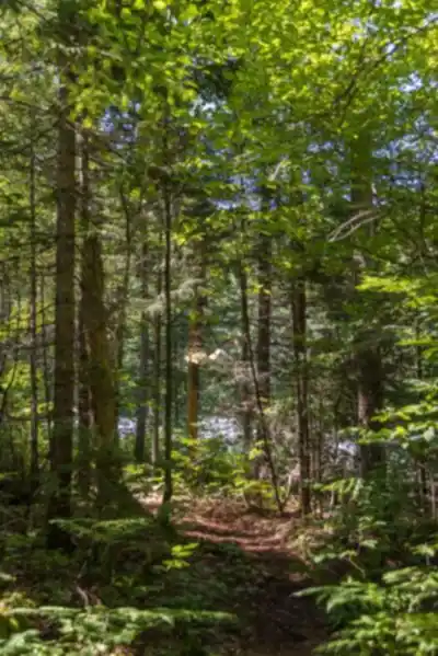
The trails at Sentiers Accès-nature Laurentides are described as meticulously maintained, which makes a noticeable difference on a longer outing. Expect clearly defined paths and a setup that supports a safe, enjoyable hike, whether you’re comfortable on challenging terrain or you’re still building experience and confidence. Because the network offers a mix of options, you can choose routes that match your pace rather than feeling locked into one “must-do” loop.
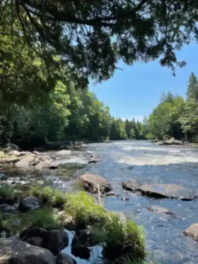
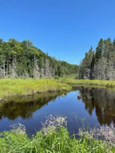
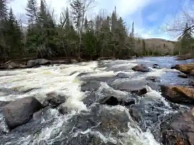
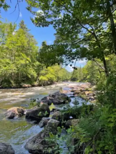
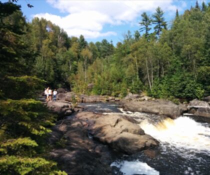
Over several kilometers, the trail system weaves through varied terrain that highlights what the Laurentides does best: dense, lush forest, rolling hills, and quieter pockets that invite you to slow down. As you move through the network, you’ll pass along sparkling streams and open up to viewpoints that look out over the surrounding hills. The route isn’t just a straight shot from point A to point B; it’s more of an unfolding walk through changing scenery, where the environment shifts enough to keep things interesting without ever feeling overly developed.
If you’re using the available route stats, plan for an 8 km outing with 670 m of elevation gain. That combination points to a demanding hike, with climbs that will have you working, especially if you’re not used to sustained elevation changes. The difficulty is listed as hard, and the estimated duration is 4h00, which makes this a good pick when you want a half-day on the trail and enough effort to feel like you earned the views.
Scenery and nature you’ll notice
The Laurentides is known for its mix of forest and rugged, rolling landscapes, and Sentiers Accès-nature Laurentides leans into that. The main visual highlights mentioned here are the rolling hills and the streams—so you can expect moments where you’re hiking under a leafy canopy and others where the trail opens up just enough to give you a sense of the wider terrain around you.
Keep your eyes open for local wildlife along the way. You might catch sight of animals in their natural habitat, especially if you hike at a steady, quiet pace and pause occasionally instead of rushing from viewpoint to viewpoint. The trail network setup also makes it easier to take your time—if one section feels busy or you want a quieter stretch, you can often choose an alternate path and keep moving without backtracking too much.
Trail conditions and navigation
Because the trails are maintained, the experience tends to be more straightforward than in places where you’re constantly negotiating blowdowns, faded blazes, or unclear junctions. That said, it’s still a trail network with multiple options, so it’s worth starting with a plan. Before heading out, stop by the visitor center to pick up maps and get up-to-date information on trail conditions. That’s the easiest way to confirm what’s open, what’s wet or rough, and which routes best match the time and effort you want to put in.
Even if you’re an experienced hiker, having the official map in hand is useful for linking trails into the kind of loop you want, estimating how much climbing you’ll be doing, and choosing the most scenic way through the area.
Who this place suits
One of the strengths of Sentiers Accès-nature Laurentides is that it works for a range of hikers. If you’re newer to hiking, you can focus on the paths that fit your comfort level and treat the day as a relaxed introduction to Laurentides terrain. If you’re a seasoned trekker, you can lean into the harder effort suggested by the 8 km / 670 m option and treat it as a more athletic outing where the climbs and rolling landscape are part of the appeal.
This is also a good destination if you’re looking for the “quiet” side of hiking—something that lets you immerse yourself in nature’s tranquility rather than ticking off a famous landmark. The atmosphere is described as peaceful, and that tends to show up in the way people hike here: a little slower, with more time for listening, watching, and taking in the forest as you go.
Beyond hiking: simple ways to spend the day
While hiking is the main draw, the area suits a handful of low-key activities that pair naturally with trail time. Bring binoculars if you enjoy birdwatching, or a camera if you like photography—between forest textures, streamside scenes, and hill views, there’s a lot to work with. If you’d rather keep things simple, plan a picnic and take advantage of the calm setting to eat outdoors before or after your hike.
These extras don’t require special infrastructure or complicated planning, which is part of the appeal here: you can hike first, then settle into a slower pace without needing to leave the area.
What to pack and how to prep
Plan like you would for a real day on the trail rather than a short stroll, especially if you’re aiming for a longer route through the network. Pack the essentials: water, snacks, and appropriate gear to stay comfortable. Good footwear matters on Laurentides terrain, where forest trails and rolling hills can mean changing footing as you climb and descend.
Because the place invites you to spend time—not just rush to an endpoint—it helps to bring enough food and water to keep your energy steady. A small extra layer can also be a smart addition in forested areas where conditions can feel cooler and more shaded than you expect, especially when you stop moving for a break.
Mindset for the experience
Sentiers Accès-nature Laurentides stands out less for one single “must-see” feature and more for the overall experience of moving through serene Laurentides landscapes on well-kept trails. It’s a spot that encourages you to pay attention to the walk itself: the sound of streams, the way the hills reveal themselves gradually, and the chance of spotting wildlife when you give the forest a little space and silence. Whether you’re seeking solitude or sharing the day with other nature lovers, the setting supports an unhurried pace and a deeper connection to the outdoors.
Services and amenities
This information may vary by season.
Recommended gear for this trail


Ready to go?
Everything you need to know before you goStarting Point
The trailhead for the Sentiers Accès-nature Laurentides is located in Saint-Sauveur, in the Laurentians region. To get there, take Highway 15 North and exit at Exit 66. Then take route 158 East and head towards Saint-Sauveur. The trailhead is on Principale Street, on the left after the bridge.
When?
How much?
- Hiking shoes Essential
- → Salomon Elixir Tour Mid WP · 203.38 $
- Layered clothing Essential
- Rain jacket Essential
- Trekking poles
- → Black Diamond Trail Ergo Cork · 69.99 $
- Headlamp
- → Petzl Actik Core 625 · 103.95 $
FAQ - Frequently asked questions
Everything you need to knowThe Essential Hiking Checklist
Everything you need for your next hike. Bilingual, printable, 1 page.
Download the free checklistSimilar hikes nearby
Discover other trails you might enjoy
Parc De La Rivière Doncaster
Laurentides

Parc Du Domaine Vert
Laurentides

Parc national d'Oka
Laurentides

Sommet Saint-Sauveur
Laurentides

Mont Condor
Laurentides

Montagne Du Dépôt Et Montagne Du Caribou
Laurentides
Hiking near Laval
97 trails to explore ~88 km away
We work hard to provide the most up-to-date and error-free data possible. If something seems incorrect, let us know! Your contribution helps the whole community.
Hikers' opinions