

Ready to explore Sentiers Ornithologiques Et Forestiers De Rivière-rouge? Here's everything you need to know before you go!
Discover the trail


Available trails
| Trails | Distance | Elevation | Duration | Difficulty | GPX |
|---|---|---|---|---|---|
| 1.5 km | 0 m | 20min | Beginner |
Trail description
Description
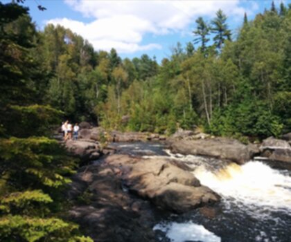
Sentiers Ornithologiques Et Forestiers De Rivière-Rouge is a quieter, nature-first trail network tucked into the Laurentides region, in the town of Rivière-Rouge. It’s the kind of place you choose when you want an unhurried walk in the woods, the chance to notice wildlife at your own pace, and a setting where the soundtrack is mostly birds and wind in the leaves rather than crowds.
The area is known for its varied landscapes and strong biodiversity, which is exactly what gives these trails their character. You’ll be moving through forested sections where the trees form a leafy canopy overhead, and the experience is less about chasing a big viewpoint and more about being immersed in the woods—cooler, shaded, and calm. Along the way, you’ll hear the steady mix of chirping birds and rustling leaves that makes this network especially satisfying for anyone who likes to slow down and pay attention to what’s around them.
Trail network and route options
The Sentiers Ornithologiques Et Forestiers De Rivière-Rouge offers a network of well-maintained paths with options that work for different comfort levels. If you’re after a gentle outing—more of a stroll with plenty of time for looking and listening—you can keep things easy and relaxed. If you’d rather make it feel like a more purposeful hike, you can choose a route that asks a bit more of you while still staying approachable.
From the practical side, this is an easy trail overall, and the distance listed for the trails is 1.5 km with about 100 m of elevation gain. Expect a walking experience where the terrain changes enough to keep things interesting without turning it into a technical challenge. Because it’s a network, it’s a good fit if your group has mixed energy levels—one person can linger at observation spots while others keep a steady pace, and it still feels like the same shared outing.
What the terrain feels like
Most of your time here is spent in forest, under taller trees that create a green, shaded corridor. The paths are described as well maintained, which makes the walking straightforward and helps keep the focus on what you came for: scenery, birds, and quiet time outdoors. The elevation gain (100 m) suggests some gentle ups and downs rather than a long, sustained climb—enough to raise your heart rate briefly, then settle back into an easy rhythm.
Because you’re moving through a living, active forest, the details change as you go: shifting light through the canopy, patches where the understory opens up a little, and moments when the woods feel especially still. It’s the sort of place where you’ll naturally pause—not because the trail demands it, but because something catches your eye or ear.
Birdwatching and wildlife viewing
This trail network stands out in the Laurentides for birdwatching. The combination of forest habitat and thoughtful trail design makes it a natural choice for anyone who likes to bring binoculars and spend time scanning the treetops and edges of the trail. You may spot hawks circling overhead, and there’s also the chance to see colorful songbirds moving quickly between branches.
One of the best features for wildlife viewing is the presence of observation points. These are positioned to give you good views while minimizing disturbance to the animals—so you can watch without needing to push off-trail or get too close. In practice, that means you’ll want to take your time at these spots: stop, listen for calls, look for movement, and you’ll often notice more than you would while walking continuously.
The experience: quiet forest time in Rivière-Rouge
Even if birding isn’t your main goal, the forested setting makes this a strong pick when you want a genuine break from day-to-day noise. The trails have that “reset” feeling: fresh air, steady shade, and the calming sense of being surrounded by trees. It’s also a good option for anyone who enjoys nature photography—especially if you like capturing small moments like birds perched in good light, texture in the bark and leaves, or the layered look of a Laurentides forest.
Because the trails are designed for a range of skill levels, it works well for a simple day outing in town or as a stop while you’re exploring more of the Laurentides region. You can treat it as a short, focused visit—walk the trails, spend time at the observation points, and leave feeling like you’ve actually been out in nature rather than just passing through it.
Planning tips and what to bring
Before you head out, it’s worth checking trail conditions so you know what to expect on the day you go. These are forest trails, and conditions can change depending on weather—especially when the ground is damp or after windier days when debris can show up on the path.
Pack the basics so you’re comfortable for the whole walk. Water is important even on a shorter outing, and a small snack is handy if you plan to linger at observation points or take your time looking for birds. Wear appropriate footwear for forest paths—something you’re happy walking in on natural surfaces with occasional unevenness. If you’re coming specifically to watch birds, bring binoculars and keep them accessible so you can stop and scan quickly when you hear activity nearby.
While you’re out there, stick to marked paths and follow leave-no-trace habits. Staying on the trail helps protect the habitat that makes this place such a good spot for wildlife in the first place, and it also keeps the observation areas working the way they’re intended—good views without stressing the animals.
Who this trail suits
With its easy difficulty and well-maintained paths, Sentiers Ornithologiques Et Forestiers De Rivière-Rouge fits a wide range of visitors: hikers who want a lighter day, outdoor enthusiasts looking for a calm forest walk, and anyone who simply wants to spend time in nature’s quiet. It’s especially rewarding if you enjoy moving at a slower pace—stopping often, listening, and letting the forest set the rhythm.
If you’re visiting Rivière-Rouge for a day trip, this trail network makes an easy, low-stress outing that still feels meaningful. If you’re spending more time in the Laurentides, it works as a restorative stop between bigger objectives—an outing where the main payoff is biodiversity, birdlife, and that peaceful “under the trees” feeling.
Services and amenities
This information may vary by season.
Recommended gear for this trail


Ready to go?
Everything you need to know before you goStarting Point
The trailhead of the Sentiers Ornithologiques Et Forestiers De Rivière-rouge is located at the intersection of Route 117 and Route 169, in the municipality of Rivière-rouge, in the Laurentian region.
When?
How much?
- Hiking shoes Essential
- → Salomon Elixir Tour Mid WP · 203.38 $
- Layered clothing Essential
- Rain jacket Essential
- Trekking poles
- → Black Diamond Trail Ergo Cork · 69.99 $
- Headlamp
- → Petzl Actik Core 625 · 103.95 $
FAQ - Frequently asked questions
Everything you need to knowThe Essential Hiking Checklist
Everything you need for your next hike. Bilingual, printable, 1 page.
Download the free checklistSimilar hikes nearby
Discover other trails you might enjoy
Parc De La Rivière Doncaster
Laurentides

Parc Du Domaine Vert
Laurentides

Parc national d'Oka
Laurentides

Sommet Saint-Sauveur
Laurentides

Mont Condor
Laurentides

Montagne Du Dépôt Et Montagne Du Caribou
Laurentides
Hiking near Gatineau
48 trails to explore ~136 km away
We work hard to provide the most up-to-date and error-free data possible. If something seems incorrect, let us know! Your contribution helps the whole community.
Hikers' opinions
Be the first to review!
No hiker has shared their experience yet. Share your impressions and help other hikers!