

Ready to explore Tour à feux de St-Rémi-d'Amherst? Here's everything you need to know before you go!
Discover the trail

Available trails
| Trails | Distance | Elevation | Duration | Difficulty | GPX |
|---|---|---|---|---|---|
| 1.5 km | 140 m | 33min | Beginner |
Trail description
Description
In the Laurentides, the Tour à feux de St-Rémi-d'Amherst is the kind of hike that feels like you’ve stumbled onto something quietly special: a forest walk with a real destination at the top. It’s centered around an old fire lookout tower, and the experience blends straightforward trail time with a bit of regional history and a strong scenic payoff.
What this hike is like
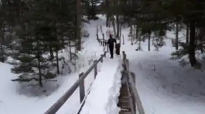
This is a moderate hike that works well for most people who are comfortable being on their feet for a couple of hours, while still feeling like a proper outing. The route is well marked, which keeps the focus on the surroundings instead of constant navigation. As you move upward, the trail carries you through dense woodland and then into more open clearings that change the feel of the walk and give you little previews of what’s coming.
Expect a steady, “earn-the-view” kind of climb rather than anything extreme. The terrain is primarily forested, so you’ll spend a lot of time under the canopy, with occasional breaks where the trees open up. Those shifts between shaded woods and brighter clearings make the hike feel varied, and they’re a good reminder that this is a living Laurentides ecosystem, not just a path to a viewpoint.
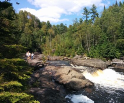
The forest setting: flora, fauna, and the Laurentides feel
One of the highlights here is simply being immersed in the Laurentides landscape. The trail is surrounded by the region’s vibrant flora and fauna, and the walk has that classic “deep woods” atmosphere: quiet, layered greens, and the sense that the forest goes on well beyond what you can see from the trail. Because the route moves between dense sections and open areas, you get different angles on that ecosystem as you go—sometimes tight and enclosed, sometimes airy and expansive.
Even if you’re not a wildlife expert, it’s the kind of place where you’ll notice how alive the woods feel. Keeping a steady pace and taking occasional pauses in the clearings makes it easier to spot movement or hear what’s happening around you.
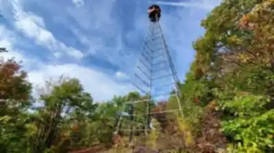
The lookout tower and why it matters
The Tour à feux de St-Rémi-d'Amherst isn’t just a hike with a nice view; it’s tied to the region’s relationship with its forests. The tower was originally built as a fire lookout tower, and it stands as a reminder of how fire lookouts once played a crucial role in forest conservation efforts. Reaching it adds a sense of purpose to the climb: you’re not only heading to a viewpoint, you’re walking toward a piece of working history that reflects how people protected these landscapes.
At the top, the tower offers insight into that era and into the delicate balance between human activity and nature’s resilience. It’s a simple but meaningful shift from “I’m here for the scenery” to “I’m standing in a place that once had an everyday job to do.”
Views at the top
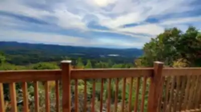
The reward for the climb is the kind of wide, panoramic perspective that makes you slow down and look around. From the top, you get sweeping vistas of rolling hills and endless forests—an unmistakable Laurentides scene. It’s also a great spot for photos, especially if you like big landscape shots, but it’s equally satisfying to just take your time and soak in how much forest stretches out in every direction.
Because the destination is elevated and open, the top can feel noticeably different than the sheltered trail below. It’s a good place to take a longer break, have a snack, and enjoy the contrast between the enclosed woodland climb and the open, big-sky view.
Route stats and time planning
- Trail: Tour à feux de St-Rémi-d'Amherst
- Region: Laurentides
- Distance: 3.2 km
- Elevation gain: 150 m
- Difficulty: Moderate
- Estimated duration: 2h00
Those numbers line up well with the overall feel: a shorter outing with enough elevation to make it feel earned. If you like to stop often for photos, take in the clearings, or spend time at the top, give yourself extra breathing room beyond the estimated time so it stays relaxed.
Who it’s good for
This hike fits a wide range of visitors. If you’re an avid hiker, it’s a satisfying moderate climb with a destination that feels distinct. If you’re mainly looking to escape into nature, the well-marked trail and the forest immersion make it approachable without feeling like a walk in a city park. It also works well for sharing with friends or family, especially if everyone enjoys a clear goal (the tower) and a viewpoint that feels like a real “we made it” moment.
If you’re aiming for solitude, it’s the kind of place that naturally encourages quiet: long stretches in the woods, a focused climb, and a top that invites lingering.
What to bring
Pack for a classic Laurentides outing where conditions can shift between the sheltered forest and the exposed top. Bring water and snacks, and wear appropriate gear for changing weather conditions. Even on a comfortable day, the tower area can feel cooler or windier than the trail, so a layer you can add or remove easily helps.
A camera is worth it here. Between the changing feel of the trail—dense woodland to open clearings—and the panoramic views from the top, there are plenty of moments you’ll want to capture, whether that’s big landscapes or smaller details along the way.
How the experience comes together
What makes the Tour à feux de St-Rémi-d'Amherst stand out is how it combines a straightforward, well-marked forest hike with a destination that adds meaning. You get the physical rhythm of a moderate climb, the sensory pull of the Laurentides ecosystem around you, and then a final viewpoint that delivers both scenery and a tangible link to the region’s forest conservation story. It’s a simple formula, but it works: walk through the woods, climb steadily, step into history, and take in a wide-open view of rolling hills and endless forest.
Services and amenities
This information may vary by season.
Recommended gear for this trail


Ready to go?
Everything you need to know before you goStarting Point
By car, take highway 15 North and exit at exit 66. Continue on Route 327 North to the village of St-Rémi-d'Amherst. The Tour à feux trailhead is at the entrance to the village on the right.
When?
How much?
- Hiking shoes Essential
- → Salomon Elixir Tour Mid WP · 203.38 $
- Layered clothing Essential
- Rain jacket Essential
- Trekking poles
- → Black Diamond Trail Ergo Cork · 69.99 $
- Headlamp
- → Petzl Actik Core 625 · 103.95 $
FAQ - Frequently asked questions
Everything you need to knowThe Essential Hiking Checklist
Everything you need for your next hike. Bilingual, printable, 1 page.
Download the free checklistSimilar hikes nearby
Discover other trails you might enjoy
Parc De La Rivière Doncaster
Laurentides

Parc Du Domaine Vert
Laurentides

Parc national d'Oka
Laurentides

Sommet Saint-Sauveur
Laurentides

Mont Condor
Laurentides

Montagne Du Dépôt Et Montagne Du Caribou
Laurentides
Hiking near Gatineau
48 trails to explore ~94 km away
We work hard to provide the most up-to-date and error-free data possible. If something seems incorrect, let us know! Your contribution helps the whole community.
Hikers' opinions