

Ready to explore Parc nature de Pointe-Aux-Outardes? Here's everything you need to know before you go!
Discover the trail

Available trails
| Trails | Distance | Elevation | Duration | Difficulty | GPX |
|---|---|---|---|---|---|
| 2.5 km | 0 m | 33min | Beginner | ||
| 1.8 km | 0 m | 24min | Beginner | ||
| 0.5 km | 0 m | 15min | Beginner | ||
| 4 km | 0 m | 53min | Intermediate |
Trail description
Description
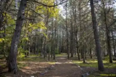
Parc Nature de Pointe-aux-Outardes is a quieter spot in the Manicouagan region that feels made for unhurried time outside. It’s the kind of place you choose when you want a real nature walk—good trails, lots to look at, and room to slow down and notice what’s happening in the landscape around you.
What makes this park different
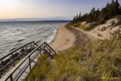
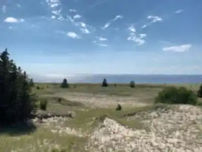
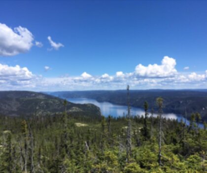
The standout here is how many distinct environments you can experience in a single visit. As you move along the park’s well-maintained trail network, you’ll pass through expansive salt marshes and open viewpoints that look out over the St. Lawrence River. That mix of shoreline views and marshland habitat is what gives the park its “rich biodiversity” feel—there’s always something changing depending on where you are on the trail.
The salt marshes aren’t just scenery; they’re a major reason people come. They provide habitat for a variety of bird species, which is why the park is often described as a birdwatcher’s paradise. Even if you’re not a dedicated birder, it’s easy to appreciate how alive the marshlands feel—watch for movement in the grasses and listen for calls as you walk.
Hiking experience and trail options
The park has several hiking trails suited to all skill levels, so it works well whether you’re planning a relaxed walk or looking for something that feels more like a “proper hike.” The terrain experience is largely about moving through natural corridors and open marsh sections rather than big climbs, with the scenery doing most of the work: wide, airy views over marsh and water, and a strong sense of being in a coastal ecosystem.
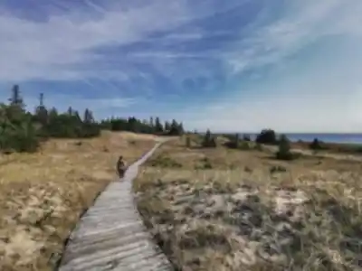
If you like having a clear plan, the main trail to know is the Sentier des Marais. It’s especially popular and is described as an easy walk through lush marshlands. This is the route to choose if you want the best chance to observe local wildlife in its natural habitat without needing advanced hiking experience. Take your time on this one—marshland viewing is often about pausing, scanning, and letting wildlife reveal itself.
For hikers who enjoy variety, the broader network of trails is part of the appeal. Because the park’s landscapes are so diverse, different routes can give you a different feel: more river views in one area, more immersion in marshlands in another. The trails are well maintained, which helps keep the outing accessible and comfortable for a wide range of visitors.
Views, wildlife, and what you’ll notice on the walk
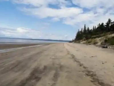
Expect a mix of big, open sightlines and more intimate stretches where the marsh vegetation wraps around the path. The St. Lawrence River views are a recurring highlight, especially when the trail opens up and you can take in the scale of the shoreline environment. The salt marshes are the other main feature—broad, textured, and full of subtle detail when you look closely.
Wildlife viewing is a big part of the experience here. The park’s marshlands are home to a variety of bird species, and the setting makes it a natural place to bring binoculars or simply take a few quiet minutes to watch and listen. “Local wildlife” isn’t limited to a single moment on the trail—it’s something you can keep an eye out for throughout your walk, especially along the Sentier des Marais where the habitat is front and centre.
Guided tours and learning opportunities
If you’re curious about what you’re seeing (and why this landscape looks and behaves the way it does), the park offers guided tours led by knowledgeable guides who are passionate about nature. These tours are a good fit if you want more than just a scenic walk—expect to gain insights into the area’s unique ecosystem, including the flora and fauna that make the region special. It’s also a helpful option if you’re visiting for the first time and want someone to point out details you might otherwise walk past.
Picnicking and taking a break
Beyond hiking, Parc Nature de Pointe-aux-Outardes is set up for simple, low-key downtime. There are designated picnic areas where you can sit down for a meal surrounded by the park’s natural scenery. This is an easy place to plan a half-day: hike first, then settle in for a picnic, or do it the other way around if you prefer to start slow and head out on the trail after.
Because the landscapes here are so photogenic—river views, open marshes, and the layered textures of the shoreline ecosystem—it’s worth bringing a camera. The scenery isn’t just “nice”; it’s the kind of environment where small changes in light and weather can make the same view feel completely different from one moment to the next.
Planning your visit
This park can work equally well as a day trip or as part of a longer stay in the Manicouagan region. If you’re visiting for the day, it’s straightforward to build a satisfying outing around an easy hike—especially on the Sentier des Marais—plus time for birdwatching and a picnic. If you’re staying longer, the park’s mix of trails and guided-tour opportunities makes it a place you can return to and still have a slightly different experience each time, depending on which trail you choose and how much time you spend observing the marshlands and river views.
For comfort on the trails, come prepared for a nature-focused walk: supportive footwear for maintained paths, something to help you stop and watch wildlife, and enough time to slow down when the scenery opens up along the St. Lawrence River.
Services and amenities
This information may vary by season.
Recommended gear for this trail


Ready to go?
Everything you need to know before you goStarting Point
To access the hiking trails, head to the main entrance where you'll find the parking lot. The address for this location is 4 Rue Labrie, Pointe-aux-Outardes, QC G0H 1M0. This serves as the primary trailhead for visitors.
When?
How much?
- Hiking shoes Essential
- → Salomon Elixir Tour Mid WP · 203.38 $
- Layered clothing Essential
- Rain jacket Essential
- Trekking poles
- → Black Diamond Trail Ergo Cork · 69.99 $
- Headlamp
- → Petzl Actik Core 625 · 103.95 $
FAQ - Frequently asked questions
Everything you need to knowThe Essential Hiking Checklist
Everything you need for your next hike. Bilingual, printable, 1 page.
Download the free checklistSimilar hikes nearby
Discover other trails you might enjoy

Boisé De La Pointe Saint-gilles
Manicouagan
Réserve faunique de Port-Cartier-Sept-Îles
Manicouagan

Centre De Vacances Ferme 5 Étoiles
Manicouagan
Hiking near Quebec City
40 trails to explore ~322 km away
We work hard to provide the most up-to-date and error-free data possible. If something seems incorrect, let us know! Your contribution helps the whole community.
Hikers' opinions