

Ready to explore Réserve faunique Mastigouche? Here's everything you need to know before you go!
Discover the trail
Available trails
| Trails | Distance | Elevation | Duration | Difficulty | GPX |
|---|---|---|---|---|---|
| 2 km | 0 m | 27min | Beginner | ||
| 2 km | 0 m | 27min | Beginner | ||
| 2 km | 0 m | 27min | Intermediate |
Trail description
Description
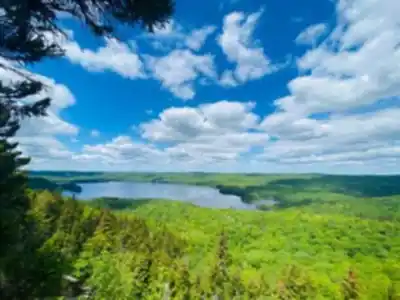
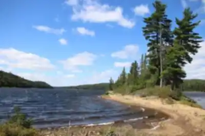
Réserve faunique Mastigouche sits in the heart of the Mauricie region and feels built for hikers who want to spend a full day (or more) moving through big, varied landscapes. This is a place of dense forest, calm lakes, rugged hills, and winding rivers—scenery that changes as you go, so the walk never feels repetitive. Whether you’re easing into hiking or you’ve got plenty of trail time behind you, the reserve’s network gives you options to match your comfort level.
What the landscape is like
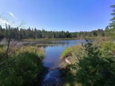
The reserve covers more than 1,500 square kilometers, and that scale shows up in the way the terrain unfolds. You’ll move through stretches of forest where the trail feels enclosed and quiet, then break out near open water where the views widen and the light changes. Lakes bring that classic Mauricie feeling—still water, green shorelines, and a calm pace—while the hills and rivers add texture and variety. Depending on the route you choose, you can stick to gentler terrain or build in climbs that reward you with broader views.
Because there are forests, lakes, hills, and rivers all within the same protected area, the experience is less about a single “main lookout” and more about a steady sequence of natural features. You’ll notice how often you’re shifting between shaded sections and more open edges near water, and how the land subtly rises and falls before you ever reach the more obvious hills. It’s the kind of place where you can focus on the walk itself—boots on trail, steady pace, lots to look at—without needing a complicated plan.
Trail network and standout hikes
One of the biggest draws here is the extensive network of trails. That network is what makes Réserve faunique Mastigouche work for different skill levels: you can choose an easier outing, or aim for a more demanding route with more climbing. If you’re visiting for the first time, it helps to think about what you want most—lakeside scenery, a viewpoint, or simply time in the forest—then pick a trail that matches that goal.
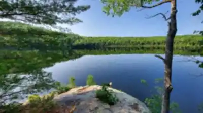
Lac Saint-Bernard trail is a favorite for good reason. It’s known for its views of clear water and lush greenery, and it’s the kind of hike where you’ll likely want to slow down, look across the lake, and take in the quieter moments along the way. The lake setting gives this route a relaxed, classic feel: water on one side, forest on the other, and plenty of natural detail to keep it interesting even if you’re not chasing steep elevation or a summit.
If you’re looking for something that feels more like a workout, Mont des Conscrits trail is the challenge route mentioned most often. It offers a rewarding climb, and the payoff is panoramic vistas that open up the landscape in a way you won’t get down near the water. Expect the climb to be the point: this is where you’ll feel the rugged hills side of the reserve more strongly, with the satisfaction of earning your views step by step.
With both of these options inside the same reserve, you can shape your trip around your energy level. Some visitors come for an easier lakeside day and others arrive specifically to put in the effort for the big views. Either way, the setting stays consistent: Mauricie wilderness, lots of space, and a trail system that lets you choose your pace.
Wildlife and what to watch for
Wildlife is part of the experience in Réserve faunique Mastigouche, and the reserve is a strong choice if you like hiking with your eyes up as much as your feet down. You may spot some of Quebec’s iconic species as you move through their habitat, including moose, white-tailed deer, and even black bears. The best approach is to stay alert, scan ahead on quieter sections of trail, and pay attention near water and forest edges where animals often travel.
Birdwatchers will also appreciate the reserve’s variety of bird species. The mix of lakes, forest cover, and open areas gives different birds different places to feed and shelter, so it’s worth listening as much as looking. Even if you’re not a dedicated birder, you’ll likely notice how the soundscape changes—especially when you shift between dense woods and shoreline areas.
Camping and relaxing by the water
Réserve faunique Mastigouche works well beyond a quick hike because it’s easy to build in downtime. After your hike, you can unwind by one of the many lakes—an easy way to extend the day without needing another big objective. Sitting near the shoreline after walking through forest and hills is often when the reserve’s scale really sinks in.
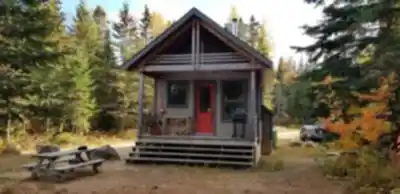
If you’re staying overnight, the reserve offers several camping options, ranging from rustic sites to more equipped spots for those who like a bit of extra comfort. Camping here is all about keeping the rhythm simple: hike, eat, rest, and spend your evening under a canopy of stars. If your goal is to be on trail early or to tackle a bigger hike like Mont des Conscrits without rushing, an overnight stay can make the whole visit feel more relaxed.
How the experience comes together
What stands out about hiking in Réserve faunique Mastigouche is how complete the setting feels. Within one protected area you get water views, thick forest, rivers that carve through the landscape, and hills that give you the option of real elevation and wide-open panoramas. That variety makes it a solid pick for different kinds of trips—an easy day focused on lake scenery, a viewpoint-driven hike with a climb, or a longer stay that mixes multiple trails with evenings at camp.
Whether you come for a single hike or plan to spend more time exploring, the reserve is set up for people who want to be outside for real: moving through changing terrain, watching for wildlife, and ending the day somewhere quiet near the water or at camp.
Services and amenities
This information may vary by season.
Recommended gear for this trail


Ready to go?
Everything you need to know before you goStarting Point
To access the hiking trails, you can start at the main entrance of the reserve. The primary trailhead is located near the reception area, which can be accessed via Route 131. From there, follow signs to the designated parking lot for visitors. Additionally, there are several other entry points and trailheads throughout the area, each with its own parking facilities. It is advisable to check a map of the reserve for specific locations and addresses of these additional trailheads before your visit.
When?
Tuesday: 7:00 AM – 10:00 PM
Wednesday: 7:00 AM – 10:00 PM
Thursday: 7:00 AM – 10:00 PM
Friday: 7:00 AM – 10:00 PM
Saturday: 7:00 AM – 10:00 PM
Sunday: 7:00 AM – 10:00 PM
How much?
- Hiking shoes Essential
- → Salomon Elixir Tour Mid WP · 203.38 $
- Layered clothing Essential
- Rain jacket Essential
- Trekking poles
- → Black Diamond Trail Ergo Cork · 69.99 $
- Headlamp
- → Petzl Actik Core 625 · 103.95 $
FAQ - Frequently asked questions
Everything you need to knowTuesday: 7:00 AM – 10:00 PM
Wednesday: 7:00 AM – 10:00 PM
Thursday: 7:00 AM – 10:00 PM
Friday: 7:00 AM – 10:00 PM
Saturday: 7:00 AM – 10:00 PM
Sunday: 7:00 AM – 10:00 PM
The Essential Hiking Checklist
Everything you need for your next hike. Bilingual, printable, 1 page.
Download the free checklistSimilar hikes nearby
Discover other trails you might enjoy

Aux berges du lac Castor
Mauricie

Domaine de la forêt perdue
Mauricie

Parc De La Rivière Batiscan
Mauricie

Parc-L'île-Melville
Mauricie

Chute du Diable
Mauricie

Aire Nature Grandes-piles
Mauricie
Hiking near Laval
97 trails to explore ~125 km away
We work hard to provide the most up-to-date and error-free data possible. If something seems incorrect, let us know! Your contribution helps the whole community.
Hikers' opinions