Hiking Chute du Diable - panoramic view
--°C
Loading...
See forecast →

Hiking in Chute du Diable: trails, map and practical info

Mauricie • Quebec

4.9 Appreciated by 11 hikers
François Dumaine
By François DumaineContributor since 2022Updated 18/06/2026
Difficulty
Easy
Distance
19 km
Elevation
100 m
Duration
5h30
Max altitude
100 m
Dogs
Allowed

Explore a 19.4 km easy trail through Mauricie's forests to powerful cascades on the Rivière Shawinigan. 5h30 round trip with just 100 m elevation gain—perfect for a full day near Shawinigan-Sud. Free access and dog-friendly.

Recommended for :
Beginners

Ready to explore Chute du Diable? Here's everything you need to know before you go!

Discover the trail

Available trails

Trails Distance Elevation Duration Difficulty GPX
9.89 km 200 m 2h30 Intermediate GPX
5.5 km 100 m 1h30 Intermediate
3.4 km 150 m 59min Advanced
Click a trail to see it on the map

Trail description

Description

Chute du Diable ("Devil's Falls") is one of those places in Mauricie that makes you slow down and pay attention. Tucked inside Parc national de la Mauricie, this waterfall on the Rivière Shawinigan delivers powerful cascades set against calm, forested surroundings—an accessible natural highlight that still feels like a genuine escape once you're on the trail.

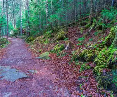
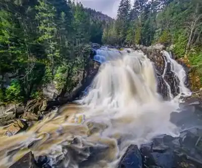
What you'll find at Chute du Diable

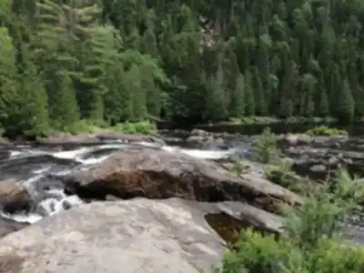
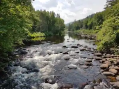
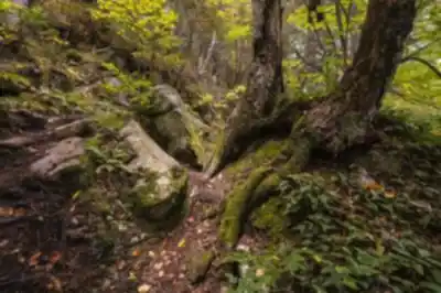
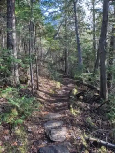
The main draw is the falls themselves: a strong rush of water dropping and churning through a rocky river channel, with the sound building steadily as you approach. Because it sits along the Rivière Shawinigan, the setting feels river-first—you're not just visiting a single viewpoint, you're moving through a landscape shaped by moving water. Expect open views near the cascades and quieter stretches where the surrounding forest softens the scene and you can hear the river well before you see it.

What makes this spot stand out within Parc national de la Mauricie is that contrast: raw, energetic water movement right in the middle of a region better known for its deep woods and layered green scenery. The waterfall gives you a clear destination without taking anything away from the walk getting there.

The hike: distance, effort, and feel

The trail is listed at 19.4 km with roughly 100 m of elevation gain and is rated easy—an estimated 5 hours 30 minutes round trip. That combination means the terrain is more about steady walking than climbing. The main effort comes from the overall distance rather than steep grades, so this is a longer day out, not a technical one.

Along the way, you'll be moving through the park's well-known forest setting: shaded sections under thick tree cover, winding paths, and gradual changes in scenery as the trail works toward the river. The walk tends to feel rewarding even before you reach the falls—you're continuously surrounded by greenery, with small details like mossy patches, shifting light through the canopy, and the gradual build of water sound as you get closer.

Trail conditions and terrain

Parc national de la Mauricie maintains a well-kept network of hiking trails, and the route to Chute du Diable fits that reputation. Expect a clearly defined path with regular foot traffic, making it approachable for a wide range of hikers. Even on an easy trail, plan for a mix of firm tread and natural surfaces—forest paths can include roots, small rocks, and occasional wet patches depending on recent weather, especially as you get closer to the river.

Because the route suits different skill levels, it's a solid match for hikers who want a longer day without technical footing. That said, the waterfall area itself is typically where people slow down and watch their steps. Any river-and-cascade setting can involve slick rocks and uneven ground near viewpoints, so sturdy footwear helps you stay comfortable over the full distance.

Nature and what to watch for

One of the simple pleasures of this hike is how much you notice when you're moving at a walking pace through Mauricie's forests. The trail passes through lush, mixed forest with vibrant ground-level flora, and the park setting means there's always a chance of spotting local wildlife. The best approach is to keep your eyes up and your pace relaxed—scan the edges of the trail, listen for movement in the brush, and take occasional quiet pauses where the forest feels especially still.

If you're bringing a camera, it's not just the waterfall that's worth shooting. Light filtering through the tree canopy, river textures, and the contrast between dark forest and bright, moving water offer good shots throughout the day, not only at the destination.

When to go

Late spring through early fall is the most practical window for most visitors. That's when the trails are generally the most accessible and the weather is best suited for a longer outing like this. Within that range, you can plan for comfortable layers, easier footing, and enough daylight to complete the distance without rushing.

If you're visiting after rain, expect damp sections on the forest floor and plan a little extra time so you can enjoy the falls without feeling pressed to turn back.

Planning tips: what to bring and how to pace it

Because this is a longer outing, comfort and pacing matter more than on a short trail. Treat it as a full hike rather than a quick stroll:

  • Bring enough water for the full distance—there's no guarantee of refill points along the way.
  • Pack real snacks, not just a granola bar. At nearly 20 km, you'll want fuel for the return leg.
  • Dress in layers. Forest cover can keep things cool even on warm days, and conditions near the river tend to feel a bit different than the open trailhead.
  • Sturdy hiking shoes or trail runners are a better call than casual footwear, especially near the waterfall where rocks can be slick.
  • A camera or a charged phone is worth having—Chute du Diable offers plenty of photo opportunities, especially where the river opens up and the cascades come into full view.

If you're newer to longer distances, the easy rating is reassuring, but the best strategy is still to start at a steady, sustainable pace. Aim to arrive at the falls with enough energy to spend real time there—take photos, sit for a few minutes, and listen to the water before heading back.

Leave No Trace

This area feels special because it's clean, natural, and well cared for. Stick to Leave No Trace principles throughout: stay on established trails, pack out everything you bring in, and avoid disturbing plants and wildlife. Around the waterfall, resist the urge to scramble off-trail for a different angle—protecting the riverbanks and surrounding vegetation keeps the site intact for everyone who comes after you.

Getting there and parking

Chute du Diable is located within Parc national de la Mauricie, within driving distance of both Montreal and Quebec City, making it realistic as either a day trip or part of a longer weekend in the region. Once you arrive at the park, you'll find parking facilities at the trailhead. It's worth arriving with a small buffer of time to get organized—lace up, adjust your pack, and settle into your pace before heading into the forest.

Services and amenities

Parking Icon Parking
Toilet Icon Toilet
Belvedere Icon Belvedere
Shelter Icon Shelter
Bridge Icon Bridge
Picnic table Icon Picnic table
Interpretation Center Icon Interpretation Center

This information may vary by season.

Recommended gear for this trail

LGPO Pick
Elixir Tour Mid WP
Salomon
Elixir Tour Mid WP
4.5 (2847 reviews)
Waterproof mid-height boot ideal for rocky terrain
203.38 $
See price
Daylite Plus 20L
Osprey
Daylite Plus 20L
4.7 (3215 reviews)
Lightweight and versatile for day hikes
109.99 $
See price
Most Popular
Wide Mouth 1L
Nalgene
Wide Mouth 1L
4.8 (12540 reviews)
Unbreakable and BPA-free — a hiking essential
23.11 $
See price
Best Value
Trail Ergo Cork
Black Diamond
Trail Ergo Cork
4.4 (1456 reviews)
Comfortable cork grip for long ascents
69.99 $
See price
Actik Core 625
Petzl
Actik Core 625
4.6 (1893 reviews)
USB rechargeable with 600 lumens for early starts
103.95 $
See price
Affiliate links — LGPO may earn a commission at no extra cost to you.

Ready to go?

Everything you need to know before you go

Where?

Address
Not available
GPS coordinates
46.64841569999999, -72.9926218
Phone
819 299-3830 (3046)

Starting Point

To get to the Devil's Fall trails, you must go to Shawinigan-Sud. Then take exit 148 and follow the signs to the site.

When?

Opening hours
From sunrise to sunset
Varies by season
Best season
Fall
Spectacular colors
Best time
Early morning
Less crowded
Weather (next days)
Loading

How much?

Entry fees
Adult
Free
Child
Free
What to bring?
Gear
Download the PDF checklist
Water & food
2L minimum
No water point on the trail
Bring energy snacks for a 4h+ hike
Good to know
Park rules
Dogs allowed
Safety
Download the GPX before you go
Limited cellular coverage on the trail
Slippery after rain
Be careful on rocky sections
In an emergency
Emergency
911
Parking GPS
46.64841569999999, -72.9926218
Center
819 299-3830 (3046)

Hikers' opinions

4.9
7 Reviews
M
Marcus
Nov 15, 2025
This trail in Mauricie offers a wonderful escape into nature with its 19.4 km route and minimal elevation gain of just 100 meters, making it accessible for most hikers. The bridges and interpretation centers along the way provide educational value and interesting stopping points. While scenic viewpoints could be more abundant, the overall experience is peaceful and well-maintained, perfect for a full day of outdoor exploration.
S
Sophie
Aug 22, 2025
An incredible journey through Mauricie's wilderness where you can truly disconnect from the world. The shelters and picnic areas scattered throughout the 19.4 km trail make it perfect for extended outdoor adventures. The easy terrain with only 100 meters of elevation gain allows you to focus on enjoying the natural surroundings and the tranquil atmosphere. Highly recommended for anyone seeking solitude and natural beauty.
D
David
Jun 10, 2025
The Devil's Falls Trail provides a solid hiking experience across its 19.4 km distance with manageable difficulty and minimal elevation change. The available facilities including parking and picnic tables are convenient, though the trail could benefit from more viewpoints to break up the journey. Free access is a major plus, and the interpretation center adds educational value to your outdoor experience.
J
Jennifer
Mar 18, 2025
A fantastic trail for families and casual hikers looking for an easy day out in Mauricie. The 19.4 km route with just 100 meters of elevation gain is perfectly suited for all fitness levels. The presence of shelters and picnic areas makes it ideal for bringing children or taking leisurely breaks. The interpretation center provides interesting context about the region's natural and cultural heritage.
T
Thomas
Dec 5, 2024
This Mauricie trail delivers excellent value with free access and well-maintained facilities throughout the 19.4 km journey. The easy difficulty rating is accurate, with only 100 meters of elevation gain making it suitable for various skill levels. Bridges and interpretation centers enhance the experience, though hikers seeking dramatic viewpoints might find them limited. Overall, a rewarding outdoor adventure.

FAQ - Frequently asked questions

Everything you need to know
Easy
100.00 M
100.00 M
5h30
Yes
No
Yes
Yes
Chute du Diable can be visited year-round from sunrise to sunset. However, spring and fall typically offer pleasant weather and scenic views of the waterfall and surrounding Mauricie landscape. Check current conditions with the park before your visit to ensure trail accessibility.
Yes, the Chute du Diable trail is rated as easy difficulty with only 100m of elevation gain, making it very suitable for children and families. The 19.4km distance and 5h30 estimated duration mean you can adjust your pace and take breaks at the available shelters and picnic tables throughout the site.
Beyond hiking, Chute du Diable offers multiple attractions including belvederes for scenic viewpoints, an interpretation center to learn about the area, and picnic facilities. The site also features bridges and shelters, making it ideal for a full day of outdoor exploration and family activities.
Didn't find your answer?
Free 1 pages

The Essential Hiking Checklist

Everything you need for your next hike. Bilingual, printable, 1 page.

Download the free checklist
Top 10 best hiking in Mauricie
Our ranking based on hiker reviews

Hiking near Laval

97 trails to explore ~128 km away

View trails
Did you spot an error?

We work hard to provide the most up-to-date and error-free data possible. If something seems incorrect, let us know!

Update : June 2026