

Ready to explore Parc national de la Mauricie? Here's everything you need to know before you go!
Discover the trail

Trail description
Description
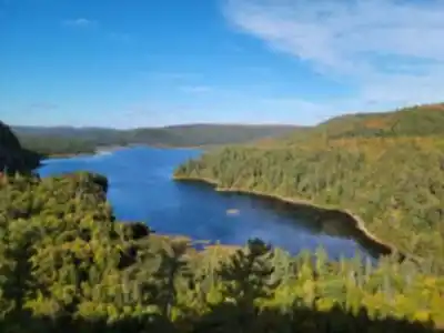
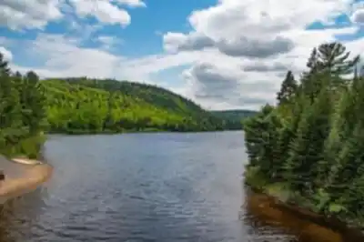
Parc national de la Mauricie covers 536 square kilometers of Quebec's Mauricie region, offering one of the province's most rewarding combinations of accessible infrastructure and genuine wilderness character. The park's trail network threads through dense boreal and mixed forest, past lakes that sit perfectly still on calm mornings, and over rocky ridges that open up long views across the Canadian Shield.
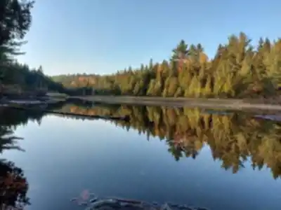
The landscape here is shaped by ancient glacial activity. Rounded granite outcrops push up through stands of sugar maple, yellow birch, and eastern hemlock, while a dense network of lakes and wetlands creates a mosaic of ecosystems that changes noticeably as you move through the park. You can go from sun-lit hardwood groves to cool, shadowy coniferous valleys within a single outing — the variety keeps things interesting no matter how many times you come back.
The Terrain
The park's topography is moderate by Quebec standards, but don't mistake that for flat. The elevation changes are enough to create distinct microclimates: valley floors stay cool and humid, while ridgetops catch the breeze and support different plant communities. That variation means the scenery shifts meaningfully as you gain and lose elevation, and the views from exposed rocky lookouts are genuinely worth the climb.
Trail surfaces range from packed earth and root-covered forest paths to wooden boardwalks that cross boggy sections near wetlands. The maintained trails are well-blazed with regular distance markers, so navigation is straightforward. More remote routes exist for hikers who want solitude over convenience.
Trail Options
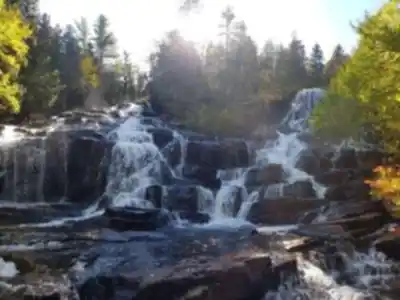
The Les Cascades trail is a solid introduction to what the park does well. This moderate 4-kilometer loop moves through mixed forest with the sound of rushing water building as you approach a series of waterfalls. The combination of forest walking and waterfall scenery makes it a reliable choice for first-time visitors or families.
For something more demanding, the Lac Solitaire trail covers 12 kilometers and climbs steadily through mature forest before reaching rocky lookouts with panoramic views over an unbroken canopy punctuated by gleaming lakes. It's a full-day commitment, but the payoff at the top is the kind of view that makes you want to stay longer than your legs will allow.
The park accommodates a wide range of hikers — families with young kids on the shorter loops, day hikers on the mid-length routes, and experienced backpackers on multi-day trips into the backcountry.
What You'll Encounter
Wildlife is a consistent part of the experience here. Moose frequent the wetlands and lake edges, especially during early morning and evening. Beaver lodges and dams appear throughout the park, and patient hikers often catch the animals themselves at work. The bird life is diverse — warblers move through the understory, and pileated woodpeckers announce themselves loudly from dead snags in the forest.
The park's lakes serve as natural rest stops along many trails. On calm days the water reflects the surrounding forest cleanly, and the shorelines make good spots to stop for lunch or just sit for a few minutes. The water clarity throughout the park reflects its protected status and the overall health of the ecosystem.
Beyond the Trails
The park's lakes open up paddling as a genuine alternative to trail hiking. Canoeing and kayaking let you explore hidden coves and observe wildlife from the water, and the network of connected lakes supports multi-day canoe camping trips for those who want to go deeper into the park without covering ground on foot.
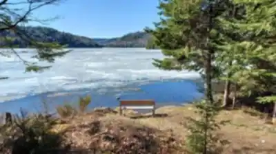
Several campgrounds are spread across the park, ranging from car-accessible sites with basic facilities to remote backcountry spots reachable only by trail or paddle. Spending a night here means falling asleep to loons calling across dark water and waking up to mist lifting off still lakes — it's a different experience than a day trip, and worth planning for if you have the time.
Practical Notes
The park's location in the Mauricie region makes it reachable from major Quebec population centers without a long drive, yet once you're on the trails it feels genuinely remote. That accessibility is one of its real strengths — you get authentic wilderness without the logistics of reaching a more distant park.
Trail conditions shift with the seasons. Spring hiking means muddy sections and stream crossings running high with snowmelt, but also rushing waterfalls and wildflowers emerging on the forest floor. Summer brings the most stable conditions and full foliage, though bug preparation is non-negotiable. Fall is when the hardwood sections earn their reputation — the maples and birches turn the forest into something worth driving a long way to see, though weather can change quickly and layers are essential.
The specific trail described on this page — with a distance of 1.6 km, 120 m of elevation gain, and a very hard difficulty rating — packs a serious physical challenge into a short distance. That elevation-to-distance ratio means steep, sustained climbing rather than a gradual ascent, and the one-hour estimated duration reflects a fast pace on demanding terrain. Come prepared with solid footwear and expect to work hard for the views.
Services and amenities
This information may vary by season.
Recommended gear for this trail


Ready to go?
Everything you need to know before you goStarting Point
Entering Saint-Jean-des-Piles: On Highway 55, take exit 226. Then turn west toward Saint-Jean-des-Piles. Continue straight until you reach the park entrance.
Note that parking is free. And there's even a recharging station for electric vehicles if you ever need one.
When?
How much?
- Hiking shoes Essential
- → Salomon Elixir Tour Mid WP · 203.38 $
- Layered clothing Essential
- Rain jacket Essential
- Trekking poles
- → Black Diamond Trail Ergo Cork · 69.99 $
- Headlamp
- → Petzl Actik Core 625 · 103.95 $
FAQ - Frequently asked questions
Everything you need to knowThe Essential Hiking Checklist
Everything you need for your next hike. Bilingual, printable, 1 page.
Download the free checklistSimilar hikes nearby
Discover other trails you might enjoy

Aux berges du lac Castor
Mauricie

Domaine de la forêt perdue
Mauricie

Parc De La Rivière Batiscan
Mauricie

Réserve Faunique Mastigouche
Mauricie

Parc-L'île-Melville
Mauricie

Chute du Diable
Mauricie
Hiking near Quebec City
40 trails to explore ~119 km away
We work hard to provide the most up-to-date and error-free data possible. If something seems incorrect, let us know! Your contribution helps the whole community.
Hikers' opinions