
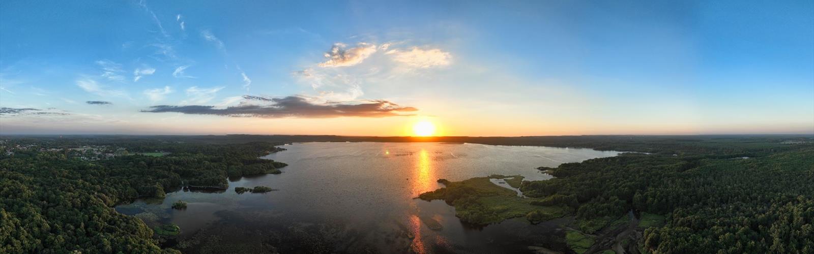

Ready to explore Réserve Naturelle du Courant d'Huchet? Here's everything you need to know before you go!
Discover the trail

Trail description
The Courant d'Huchet Nature Reserve, tucked into the Landes department of Nouvelle-Aquitaine, is one of southwestern France's most quietly impressive protected areas. It's the kind of place that doesn't announce itself loudly — no dramatic cliffs, no sweeping panoramas — but rewards anyone who slows down and pays attention. The trail here covers 6 km with barely 10 meters of elevation gain, making it genuinely accessible for all fitness levels, and most visitors complete it in around an hour and a half.
What makes this reserve worth the visit is the sheer variety packed into a compact area. Within a short walk, you move through dense mixed forest, open moorland, delicate wetland fringes, and the banks of the Courant d'Huchet itself — the stream that gives the reserve its name and its character.
The Courant d'Huchet Stream
The stream is the backbone of everything here. Fed by rainwater and smaller tributaries filtering through the surrounding forest, the Courant d'Huchet runs fast and cold year-round before eventually reaching the Atlantic. That consistent cold temperature isn't just a detail — it's what makes the waterway a critical refuge for fish species that need highly oxygenated, stable conditions to reproduce.
Walking alongside it, you feel its influence immediately. The sound of moving water follows you through much of the trail. The air near the banks is noticeably cooler and more humid than in the open moorland sections. The stream shapes the soil moisture, the vegetation, and ultimately the entire ecosystem on either side of it. It's not a passive feature of the landscape — it's the engine driving the reserve's ecological richness.
Forest Environments
The forest covers the largest portion of the reserve and it's far from uniform. Oak, beech, and pine all share the canopy here, each contributing something different to the overall ecosystem. The oaks offer long-term structural stability and produce acorn crops that feed a range of wildlife. The beeches create dense shade and generate deep leaf litter on the forest floor — the kind of rich, decomposing organic layer that supports everything from fungi to small invertebrates. The pines bring evergreen cover and that distinctive resin scent that hits you in certain sections of the trail.
Moving through these wooded stretches, you notice how the forest's personality shifts depending on which species dominates. Beech-heavy sections feel enclosed and cathedral-like, with filtered light and a hushed quality underfoot. Pine sections open up slightly, with more light reaching the ground and a drier, airier feel. These aren't dramatic transitions, but they're real, and they keep the walk from feeling repetitive.
The forest canopy also creates a layered habitat system — birds nesting and feeding high up, smaller mammals using the understory for shelter, and a whole community of decomposers working the forest floor. That vertical complexity is part of what makes mixed forests like this one so ecologically productive compared to monoculture plantations.
Moorland Sections
Where the forest opens up, the trail passes through moorland areas dominated by heather, broom, and bramble. These transitional zones have a completely different energy — lower vegetation, more sky, and a sense of exposure after the enclosed forest sections. The heather and broom create seasonal color, while the brambles produce berries that attract wildlife and the occasional opportunistic hiker.
These edge habitats are often the best spots for wildlife observation. Animals that prefer the cover of the forest will venture into these open areas to feed, particularly in the early morning and late afternoon. The moorlands also serve an important ecological function — their root systems stabilize the soil at the forest edge, and their vegetation stores carbon in ways that complement the forest's own climate role.
Wetland Areas
The wetlands are the most fragile part of the reserve, and also among the most rewarding to observe carefully. Found primarily along the edges of the Courant d'Huchet and other waterways, these areas depend on precise moisture levels and water chemistry to maintain their character. The ground here is noticeably softer, the vegetation denser and greener, and the air carries more humidity than anywhere else on the trail.
Aquatic grasses, mosses, and bog-adapted plants create microhabitats that are essential for amphibians, insects, and birds during critical parts of their life cycles. These aren't species that can simply relocate if the wetland disappears — they're tied to these specific conditions. That dependency is exactly why the reserve's protected status matters. Patient observers who spend time near these sections, especially during breeding seasons, are often rewarded with close wildlife encounters that wouldn't happen in more disturbed environments.
How the Ecosystems Connect
One of the things that sets the Courant d'Huchet Nature Reserve apart from a simple forest walk is how clearly you can see the relationships between its different environments. The stream feeds the wetlands. The forest moderates temperature and humidity across the entire reserve. The moorlands create transition zones where species from multiple habitats overlap. None of these environments functions in isolation — changes in one ripple through the others.
That interconnection is also what makes the reserve a meaningful refuge in a region where natural habitats face ongoing pressure from development and agricultural conversion. Protected areas like this one allow natural processes to continue without interference, giving both common and less common species the stability they need to maintain healthy populations.
What to Expect on the Trail
The route is flat — 10 meters of elevation gain over 6 km means you're essentially walking on level ground the entire time. There are no technical sections, no exposed ridges, and no significant obstacles. The trail is well-suited to families with children, older hikers, and anyone looking for a relaxed outing focused on nature observation rather than physical challenge.
The 1h30 estimated duration assumes a moderate pace with some stops to look around. If you're the type to pause at the stream, watch for birds in the wetland margins, or simply sit quietly in the forest for a few minutes, budget a bit more time. The reserve rewards that kind of unhurried attention in a way that a faster pace simply doesn't allow.
Footwear with some grip and water resistance is a practical choice, particularly near the wetland sections where the ground can be soft and damp regardless of recent weather conditions.
The Essential Hiking Checklist
Everything you need for your next hike. Bilingual, printable, 1 page.
Get your free hiking checklistRecommended gear for this trail
As an Amazon Associate I earn from qualifying purchases.


Ready to go?
Everything you need to know before you goStarting Point
The trailhead for the Courant d'Huchet Nature Reserve is located in Saint-Pardoux-la-Rivière, in Nouvelle-Aquitaine.
When?
How much?
As an Amazon Associate I earn from qualifying purchases.
Affiliate links — LGPO may earn a commission at no extra cost to you.
- Hiking shoes Essential
- → Salomon Elixir Tour Mid WP · 203.38 $
- Layered clothing Essential
- Rain jacket Essential
- Trekking poles
- → Black Diamond Trail Ergo Cork · 69.99 $
- Headlamp
- → Petzl Actik Core 625 · 103.95 $
FAQ - Frequently asked questions
Everything you need to knowSimilar hikes nearby
Discover other trails you might enjoy
Hiking near Sydney
22 trails to explore ~4539 km away
We work hard to provide the most up-to-date and error-free data possible. If something seems incorrect, let us know! Your contribution helps the whole community.
Hikers' opinions
Be the first to review!
No hiker has shared their experience yet. Share your impressions and help other hikers!