

Ready to explore Lac d'Estom? Here's everything you need to know before you go!
Discover the trail
Oh no! We don't have any photos 😢
This trail hasn't been captured yet. Be the first to share your adventure!Trail description
The hike to Lac d'Estom is one of those routes in the Hautes-Pyrénées that earns its reputation honestly. It's not the longest day out, but the combination of varied terrain, a dramatic glacial cirque, and a genuinely beautiful alpine lake makes it a standout experience in the Pyrenees National Park. At 8 km round trip with 520 m of elevation gain, it sits comfortably in the moderate category — challenging enough to feel earned, accessible enough for hikers who are reasonably fit and comfortable on mountain terrain.
The trail starts from the Pont d'Espagne area, a well-known launching point for exploring this part of the national park. Parking here fills up fast during peak season, especially on summer weekends, so an early start isn't just a suggestion — it's genuinely the difference between a relaxed morning and a frustrating scramble for a spot. Fees apply during the main season, so come prepared. Once you're on the trail, the crowds thin out quickly as you move away from the busier Pont d'Espagne area.
The Trail Experience
The first section of the hike moves through dense forest — beech and fir mostly — with the sound of rushing water keeping you company. Several mountain streams run alongside and across the path, and the forest light in the morning hours makes this stretch genuinely pleasant. The grade here is relatively gentle, which gives you time to warm up before the terrain gets more serious.
As you gain elevation, the trees thin out and the landscape opens up. Rhododendron bushes take over where the forest ends, and in summer the wildflowers across the alpine meadows add real color to the route. The path gets rockier as you climb, and the views start to open up in a way that makes you want to stop more often than you probably should if you're watching the weather.
The upper section of the trail is where the hike shifts character. The terrain becomes more rugged, with loose stones and sections that require some attention to foot placement. There's no technical climbing involved, but you do need to be comfortable moving over uneven, rocky ground. The trail is well-marked throughout, so navigation isn't a concern — it's more about staying steady and taking your time on the rockier stretches. The path can get slippery when wet, which is worth keeping in mind given how quickly afternoon weather can move in at this elevation.
Lac d'Estom
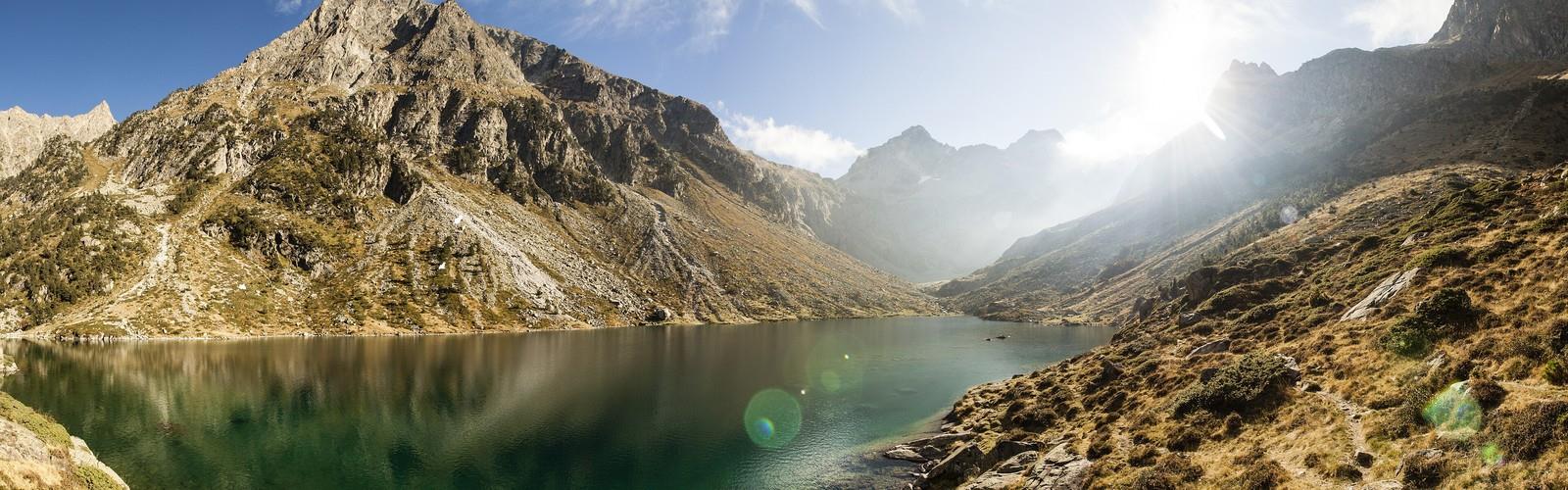
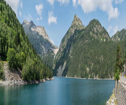
The lake itself sits in a spectacular glacial cirque, with steep rock walls rising on multiple sides and the kind of scale that takes a moment to fully register when you arrive. The water runs deep blue-green, and on calm mornings the reflections of the surrounding peaks are sharp enough to make you stop and stare. It's the sort of place that looks like a photograph even when you're standing in it.
The cirque shows clear evidence of glacial shaping — the rock faces, the bowl-like form of the basin, the way the landscape feels carved rather than simply steep. In early summer, snow patches often remain on the higher slopes and in shadowed corners, which adds to the high-mountain atmosphere even when the main trail is clear. Large boulders around the lake's edge make natural spots to sit, eat, and take in the surroundings before heading back down.
Wildlife is a real part of the experience here. Marmots are common and vocal — you'll likely hear their sharp whistles before you spot them on the rocky slopes. Chamois are sometimes visible on the higher terrain above the cirque. The area supports a range of alpine bird species as well, and the relative quiet of the upper trail makes wildlife encounters more likely than on busier routes.
Terrain and Conditions
The trail is well-maintained and clearly signed, which makes it approachable for hikers who don't have extensive mountain experience — as long as they're honest about their fitness level and comfortable with rocky, uneven ground. The elevation gain of 520 m is steady rather than brutal, but it's consistent enough that you'll feel it, particularly in the upper half of the route.
Footwear matters here. Trail runners or hiking boots with solid grip are the right call — the rocky sections and potential for wet conditions make anything less than that a liability. Trekking poles are useful on the descent, especially on loose stone.
Weather deserves serious attention. Afternoon thunderstorms are a real pattern during summer months, and the exposed upper trail and open cirque offer no shelter. Starting early gives you the best chance of reaching the lake and getting back below the exposed sections before conditions deteriorate. Carrying a rain layer and being willing to turn around if the sky looks threatening is just good mountain sense on this route.
Seasonal Notes
The trail is typically accessible from late spring through early fall, with June through September offering the most reliable conditions. Early season means snowmelt, muddy sections, and possible snow on the upper trail — doable, but worth checking conditions before you go. Late summer and early fall bring more stable weather and fewer people, though the window before early winter weather arrives at altitude is shorter than it feels.
Summer is peak season, and the Pont d'Espagne area reflects that. The lake itself sees significant visitor traffic on clear summer days. An early start addresses both the parking situation and the crowds at the lake.
Practical Notes
The hike is suitable for families with older children who have some experience with longer mountain days and aren't put off by rocky terrain. The distance and elevation gain, combined with the more technical upper section, make it a poor fit for very young hikers or anyone without a baseline of mountain hiking experience.
Dogs are allowed on the trail and must be kept under control, particularly in wildlife habitat areas. The rocky terrain is demanding for dogs as well, so assess your animal's fitness and paw condition honestly before bringing them along.
Carry more water than you think you need — reliable water sources become scarce in the upper portions of the trail. A basic first aid kit, sun protection, and weather layers round out the essentials for a day on this route.
The Essential Hiking Checklist
Everything you need for your next hike. Bilingual, printable, 1 page.
Get your free hiking checklistRecommended gear for this trail
As an Amazon Associate I earn from qualifying purchases.


Ready to go?
Everything you need to know before you goWhen?
How much?
As an Amazon Associate I earn from qualifying purchases.
Affiliate links — LGPO may earn a commission at no extra cost to you.
- Hiking shoes Essential
- → Salomon Elixir Tour Mid WP · 203.38 $
- Layered clothing Essential
- Rain jacket Essential
- Trekking poles
- → Black Diamond Trail Ergo Cork · 69.99 $
- Headlamp
- → Petzl Actik Core 625 · 103.95 $
FAQ - Frequently asked questions
Everything you need to knowSimilar hikes nearby
Discover other trails you might enjoy
Hiking near Sydney
22 trails to explore ~4680 km away
We work hard to provide the most up-to-date and error-free data possible. If something seems incorrect, let us know! Your contribution helps the whole community.
Hikers' opinions
Be the first to review!
No hiker has shared their experience yet. Share your impressions and help other hikers!