


Ready to explore italy 14? Here's everything you need to know before you go!
Discover the trail
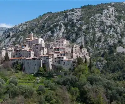
Trail description
The Italy 14 mountain bike route sits in the Alpes-Maritimes department of the Provence-Alpes-Côte d'Azur region in France, right along the border with Italy. This is high-alpine terrain where the landscape shifts dramatically depending on elevation — rocky ridgelines, open meadows, dense conifer forests, and the kind of views that make you stop pedaling just to take it all in.
This route is part of a broader network of trails in the Alpes-Maritimes that connect French and Italian territory, making it genuinely cross-border riding in both spirit and geography. The "Italy 14" designation points to its position within a numbered trail system designed to help riders navigate this complex mountain environment with some consistency.
The Terrain
Expect technical mountain bike terrain throughout. The Alpes-Maritimes is not a region that eases you in gently — the mountains here are serious, with steep gradients, loose rock sections, and exposed ridges that demand both physical fitness and solid bike-handling skills. The trails in this area tend to mix natural singletrack with older mule paths and military roads, a legacy of the strategic importance this border zone held for centuries.
The surface conditions vary considerably depending on the section you're riding. Some stretches are smooth and fast, while others are chunky and technical, requiring careful line selection. Riders should be comfortable managing their bike on loose terrain and navigating sections where the trail narrows significantly.
What Makes This Route Stand Out
What sets Italy 14 apart from other mountain bike routes in the region is its position straddling two countries. Riding here, you're moving through a landscape that has been shaped by both French and Italian history — old border fortifications, stone shelters, and waypoints that predate modern trail infrastructure are scattered throughout the area. The Mercantour National Park and the adjacent Alpi Marittime Natural Park in Italy form one of the largest protected cross-border areas in Europe, and this route passes through or near this remarkable zone.
The biodiversity in this corridor is exceptional. The Alpes-Maritimes is known for its unusual range of ecosystems compressed into a relatively small geographic area — Mediterranean scrubland at lower elevations transitions to alpine tundra near the summits. Riders moving through this terrain experience that transition firsthand, which gives the route a character that's hard to find elsewhere in France.
Who This Route Is For
Italy 14 is best suited for experienced mountain bikers who are comfortable with sustained climbs, technical descents, and remote conditions. This is not a beginner-friendly outing. The alpine environment means that conditions can change quickly, and riders should be self-sufficient with tools, spare parts, food, and water. Cell coverage in the higher sections is unreliable, so planning ahead matters.
That said, strong intermediate riders who are building their skills in alpine terrain will find this route genuinely rewarding. The challenge is real, but so is the payoff — the riding here is the kind that stays with you.
Getting There and Access
Access to mountain bike routes in the Alpes-Maritimes typically involves driving into the mountain valleys from the coast or from larger towns in the region. The road network in this part of France can be narrow and winding, so allow extra travel time and check road conditions before heading out, especially earlier and later in the season when snow or ice can affect higher passes.
Parking availability depends on the specific trailhead for Italy 14 — smaller pull-offs and village parking areas are common in this region. Arriving early on weekends is a good habit, as popular trailheads in the Alpes-Maritimes can fill up during peak season.
Seasonal Considerations
The riding season in the high Alpes-Maritimes is shorter than at lower elevations. Snow can linger well into spring at altitude, and early fall storms can arrive sooner than expected. The core riding window in this kind of terrain typically runs from late spring through early fall, but conditions vary year to year. Always check local trail conditions and weather forecasts before heading out — the mountains here don't reward complacency.
Summer riding in the Alpes-Maritimes comes with heat at lower elevations and afternoon thunderstorms at altitude. Starting early in the day is standard practice for anyone riding in the high mountains during July and August.
What to Bring
- Navigation tools: A downloaded map or GPS track is essential. Trail signage in remote sections can be sparse or weathered.
- Repair kit: Tubes, a pump, a multi-tool, and a chain tool at minimum. Mechanical help is not close by.
- Water: Carry more than you think you need. Mountain springs exist in the area but should be treated before drinking.
- Layers: Temperature drops quickly with elevation gain. A wind layer and a light insulating piece are worth the weight.
- First aid basics: Given the remote nature of the terrain, a small kit and the knowledge to use it is smart preparation.
- Helmet and protective gear: Non-negotiable on technical alpine terrain.
The Broader Network
Italy 14 connects into a wider trail network that spans the Alpes-Maritimes and crosses into the Italian side of the Maritime Alps. Riders who want to extend their time in the area will find additional routes that complement this one, ranging from more accessible valley rides to demanding high-alpine circuits. The cross-border nature of the network is one of its genuine strengths — it opens up a riding area that feels expansive and exploratory rather than contained.
The Alpes-Maritimes as a whole is an underrated destination for serious mountain bikers who want alpine terrain without the crowds that concentrate in more famous French mountain regions, and Italy 14 is a solid example of what makes this corner of France worth the trip.
Recommended gear for this trail


Ready to go?
Everything you need to know before you goWhen?
How much?
- Hiking shoes Essential
- → Salomon Elixir Tour Mid WP · 203.38 $
- Layered clothing Essential
- Rain jacket Essential
- Trekking poles
- → Black Diamond Trail Ergo Cork · 69.99 $
- Headlamp
- → Petzl Actik Core 625 · 103.95 $
FAQ - Frequently asked questions
Everything you need to know
25 hikes under 2 hours from Montreal
Distance, elevation, parking and season for each one. The ones we go back to ourselves.
Get the guideSimilar hikes nearby
Discover other trails you might enjoy
Sentier du Littoral
Alpes-Maritimes
Parc national du Mercantour
Alpes-Maritimes
Le Sentier du Littoral
Alpes-Maritimes

Parc naturel régional des Préalpes d'Azur
Alpes-Maritimes
Cascade De Clars
Alpes-Maritimes
Gorges de la Siagne
Alpes-Maritimes
Hiking near Sydney
22 trails to explore ~5172 km away
We work hard to provide the most up-to-date and error-free data possible. If something seems incorrect, let us know! Your contribution helps the whole community.
Hikers' opinions
Be the first to review!
No hiker has shared their experience yet. Share your impressions and help other hikers!