

Ready to explore Camping de l'Étang de la Bonde? Here's everything you need to know before you go!
Discover the trail
Trail description
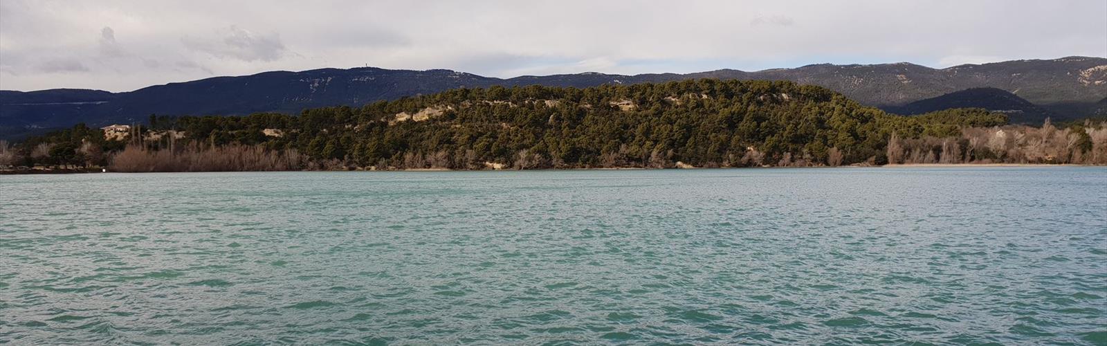
Camping de l'Étang de la Bonde sits in the heart of Vaucluse in the Luberon Regional Nature Park, one of Provence-Alpes-Côte d'Azur's most quietly rewarding inland departments. The draw here isn't dramatic peaks or famous gorges — it's something more understated: a genuine pond at the center of a working campground, surrounded by Aleppo pines and the kind of Mediterranean scrubland that rewards slow, attentive exploration.
This is a 2.9 km out-and-back loop with an elevation change of around 50 meters that takes roughly 30 minutes to 1 hour to complete, making this firmly easy terrain. That's not a limitation — it's the point. Camping de l'Étang de la Bonde suits families with young kids, older adults looking for a relaxed outdoor experience, and anyone who wants to spend time in a natural setting without committing to a strenuous day out.
The Pond at the Center of It All
The étang itself is what defines this place. It's a calm, reflective body of water that changes character throughout the day — misty and still in the early morning, bright and active at midday, golden and alive with wildlife movement as the sun drops. Walking the shoreline paths, you get a different read on the water depending on where you stand: level sections right at the edge, slightly elevated banks where the terrain rises and opens up the view across the pond and into the surrounding Var countryside.
The pond's margins support a layered plant community — emergent aquatic vegetation close to the water, moisture-loving shrubs just beyond, then the drier Mediterranean scrub as you move uphill. These transition zones are worth paying attention to. They concentrate wildlife in predictable ways, especially at dawn and dusk.
Birdlife is one of the genuine highlights. Herons work the shallows with their characteristic patience. Ducks move across the deeper sections. Songbirds are active in the surrounding vegetation, particularly in the early morning. Kingfishers show up if you're quiet and lucky — watch for the flash of blue-orange along the water's edge. The muddy margins attract smaller wading birds that are easy to overlook but worth the attention.
Terrain Beyond the Shoreline
Step back from the water and you're in classic inland Var landscape. Low hills covered in garrigue roll out in every direction, the vegetation a mix of gray-green tones punctuated by limestone outcroppings that hold the heat of the Mediterranean sun. The 50-meter elevation change is enough to shift your perspective without demanding much from your legs.
The plant life here is aromatic and tactile. Thyme, rosemary, and lavender grow wild among the rocks — brush against them and the scent is immediate and strong. Holm oaks and Aleppo pines dot the hillsides, their dark canopies offering real shade when the sun is high. The soil and rock composition is typical of Provençal upland terrain: dry, well-drained, and supporting plants that have adapted to long dry summers and mild winters.
Seasonal shifts change the area noticeably. Spring and winter are the best periods for visiting this area, when the landscape is most visually dramatic with wildflowers filling in the spaces between shrubs. Summer shifts the palette toward silver and muted earth tones as drought-adapted plants come into their own, but water levels in the pond may be lower. Autumn brings more comfortable walking temperatures and the color change of any deciduous trees in the mix.
The Campground Setup
The camping facilities work with the landscape rather than against it. Established sites offer level ground for tents and RVs, with mature trees providing natural windbreaks and shade. Some spots sit in open sun; others tuck under tree canopies for more shelter and privacy. The variety means you can pick a site that matches what you're actually looking for — whether that's morning sun, afternoon shade, or proximity to the water.
The pond is close enough from most camping areas that getting there doesn't require any real effort. Short, gentle slopes connect the camping zones to the shoreline, which matters when you're moving gear, fishing equipment, or kids back and forth throughout the day. The layout respects the natural contours of the land, so nothing feels forced or out of place. A picnic area and refreshment bar are located near the lake.
What to Do Here
Swimming is possible in the pond during summer months. Fishing is a natural fit for this setting, with different sections of the shoreline offering different depths and structure, giving anglers options depending on what they're targeting. The calm water also works for non-motorized watercraft — kayaks or small boats suit the scale and character of the étang well.
Photography finds good material throughout the day. The pond gives you reflections and light play in the morning and evening. The surrounding garrigue offers close-up subjects — insects on aromatic herbs, lichen on limestone, the texture of bark on old oaks. Wider compositions work too, with the water, hills, and sky combining into the kind of layered Provençal scene that's hard to get wrong.
For families or anyone interested in natural history, the pond ecosystem is genuinely educational in an accessible way. The visible transitions between aquatic, shoreline, and upland environments make ecological relationships easy to observe and discuss without needing any specialized knowledge to appreciate what's happening.
Practical Notes
The Luberon Regional Nature Park's Mediterranean climate means spring and winter are the most comfortable seasons for spending time outdoors here. Summer works, but heat and strong sun are real factors — the pond moderates things somewhat compared to more exposed locations, but preparation matters. Sunscreen, water, and early starts make a significant difference in July and August. Water levels in the étang shift with the seasons, and late summer and early fall may show lower levels.
The terrain throughout the area is genuinely accessible. The modest elevation changes mean that most of the paths around the pond work for visitors with varying mobility levels. The combination of easy walking, natural beauty, and campground amenities makes Camping de l'Étang de la Bonde a practical base for anyone wanting to spend real time in the Vaucluse without the intensity of more demanding destinations.
The Essential Hiking Checklist
Everything you need for your next hike. Bilingual, printable, 1 page.
Get your free hiking checklistRecommended gear for this trail
As an Amazon Associate I earn from qualifying purchases.


Ready to go?
Everything you need to know before you goWhen?
How much?
As an Amazon Associate I earn from qualifying purchases.
Affiliate links — LGPO may earn a commission at no extra cost to you.
- Hiking shoes Essential
- → Salomon Elixir Tour Mid WP · 203.38 $
- Layered clothing Essential
- Rain jacket Essential
- Trekking poles
- → Black Diamond Trail Ergo Cork · 69.99 $
- Headlamp
- → Petzl Actik Core 625 · 103.95 $
FAQ - Frequently asked questions
Everything you need to knowSimilar hikes nearby
Discover other trails you might enjoy

Hiking near Sydney
22 trails to explore ~5039 km away
We work hard to provide the most up-to-date and error-free data possible. If something seems incorrect, let us know! Your contribution helps the whole community.
Hikers' opinions
Be the first to review!
No hiker has shared their experience yet. Share your impressions and help other hikers!