

Ready to explore Mount Kineo? Here's everything you need to know before you go!
Discover the trail
Trail description
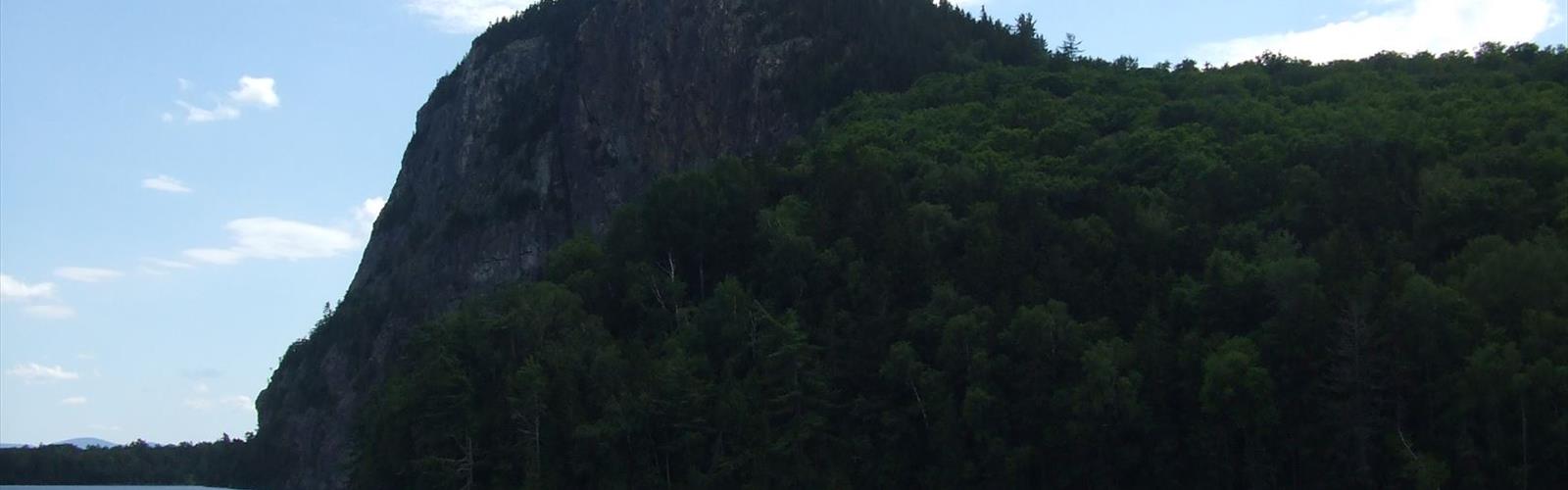
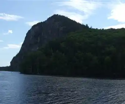
Mount Kineo rises dramatically from the waters of Moosehead Lake, forming one of the most striking natural landmarks in Maine. This massive rhyolite cliff — one of the largest in the eastern United States — juts out from a peninsula accessible only by water, which gives the whole experience a sense of genuine remoteness that's hard to find elsewhere in the region. Getting there is part of the adventure.
Getting to Mount Kineo
There's no road to the trailhead. To reach Mount Kineo, you need to cross Moosehead Lake by boat. A seasonal ferry shuttle operates from the town of Rockwood, carrying hikers across to the Kineo peninsula. This water crossing isn't just a logistical detail — it sets the tone for the day. You're arriving somewhere that feels genuinely cut off from the everyday, surrounded by open water with the cliffs already visible ahead of you.
If you have your own canoe, kayak, or motorboat, you can paddle or motor across independently. The crossing from Rockwood is short, but Moosehead Lake is a large, open body of water, so conditions can change. Check the weather before heading out on the water.
The Terrain and the Climb
Mount Kineo's trail network takes you through forested terrain before opening up onto exposed ridgeline and cliff-top views. The mountain is composed primarily of rhyolite, a fine-grained volcanic rock that gives the cliffs their distinctive dark, almost glassy appearance. This same rock was prized by Indigenous peoples for thousands of years — Kineo rhyolite was used to make tools and has been found at archaeological sites across a wide area of northeastern North America, which speaks to how significant this place was long before European settlement.
The trails on the peninsula include options that range from a relatively easy walk along the shoreline to a steeper climb up to the fire tower at the summit. The Indian Trail is the more direct and challenging route to the top, with some steep sections and exposed rock. The Bridle Trail offers a longer, more gradual approach through the woods. Most hikers combine both to make a loop.
At the summit, a historic fire tower stands above the treeline. Climbing it rewards you with a panoramic view over Moosehead Lake — Maine's largest lake — and the surrounding forested hills stretching in every direction. On a clear day, the scale of the landscape is genuinely impressive. This is remote Maine, and the view makes that obvious.
What Makes This Place Stand Out
A few things make Mount Kineo different from a typical day hike. First, the approach by water is unusual and memorable. Second, the geology is exceptional — those sheer rhyolite cliffs dropping straight into the lake are unlike anything else you'll see in Maine. Third, the historical and cultural depth of the site adds real meaning to the visit. Kineo has been a destination for a long time: Indigenous peoples, 19th-century tourists who arrived by steamboat to stay at the grand Kineo House resort, and today's hikers all share a connection to this peninsula.
The Kineo House itself is long gone in its original grand form, but the golf course on the peninsula is a remnant of that resort era. It's a bit of an unexpected sight — a manicured fairway in the middle of the Maine wilderness — but it's part of the layered history of the place.
Wildlife and Natural Environment
Moosehead Lake and the surrounding forests are classic Maine habitat. Moose are genuinely common in this part of the state, and the area around Kineo is no exception. Early morning and evening are the best times to spot them, particularly near the water's edge and in boggy areas. Loons are a constant presence on the lake, and their calls carry across the water throughout the day.
The forests on the peninsula are a mix of northern hardwoods and conifers typical of the Maine highlands. Birdwatching can be rewarding, especially during migration seasons, and the lake itself supports a healthy fish population that draws anglers to the region.
Practical Information
- Access: Water access only. The ferry shuttle from Rockwood is the most common option for hikers without their own watercraft. Check current shuttle schedules and availability before your trip, as service is seasonal.
- Parking: There is a small parking area in Rockwood near the ferry landing.
- Season: The trails are most accessible from late spring through fall. Winter access is possible by snowmobile across the frozen lake when conditions allow, but this requires local knowledge and caution.
- Dogs: Dogs are generally welcome on the trails. Keep them under control, especially near the cliff edges.
- Leave No Trace: The peninsula is a relatively fragile environment given its size and the volume of visitors it receives in summer. Pack out everything you bring in.
- Cell service: Limited to nonexistent in this area. Download offline maps before you go and let someone know your plans.
Tips for Your Visit
Arrive early, especially on summer weekends. The ferry has limited capacity and the trails on the peninsula are not enormous — it can feel crowded by midday in peak season. An early start also gives you the best chance of calm water for the crossing and cooler temperatures for the climb.
Bring more water than you think you need. There are no reliable water sources on the trail, and the climb to the summit in warm weather is more demanding than the modest elevation might suggest.
The fire tower at the summit is worth the extra effort of climbing it. The enclosed cab at the top provides a 360-degree view that you simply can't get from the treeline below — it's one of the better fire tower experiences in Maine.
If your schedule allows, spending time on the shoreline before or after the hike is worthwhile. The views back toward the cliffs from the water level are completely different from what you see on the trail, and the combination gives you a much fuller sense of just how dramatic this landform really is.
The Essential Hiking Checklist
Everything you need for your next hike. Bilingual, printable, 1 page.
Get your free hiking checklistRecommended gear for this trail
As an Amazon Associate I earn from qualifying purchases.


Ready to go?
Everything you need to know before you goWhen?
How much?
As an Amazon Associate I earn from qualifying purchases.
Affiliate links — LGPO may earn a commission at no extra cost to you.
- Hiking shoes Essential
- → Salomon Elixir Tour Mid WP · 203.38 $
- Layered clothing Essential
- Rain jacket Essential
- Trekking poles
- → Black Diamond Trail Ergo Cork · 69.99 $
- Headlamp
- → Petzl Actik Core 625 · 103.95 $
FAQ - Frequently asked questions
Everything you need to knowSimilar hikes nearby
Discover other trails you might enjoy
South Peak
Aroostook County
Allagash Mountain
Aroostook County
Penobscot River Trails
Aroostook County

Fish River
Aroostook County
Deboullie Public Reserved Land
Aroostook County
Grand Falls
Aroostook County
Hiking near Bangor
0 trails to explore ~125 km away
We work hard to provide the most up-to-date and error-free data possible. If something seems incorrect, let us know! Your contribution helps the whole community.
Hikers' opinions
Be the first to review!
No hiker has shared their experience yet. Share your impressions and help other hikers!