


Ready to explore Smith River Its confluence to the Missouri River? Here's everything you need to know before you go!
Discover the trail
Oh no! We don't have any photos 😢
This trail hasn't been captured yet. Be the first to share your adventure!Trail description
The Smith River from its confluence to the Missouri River represents one of Montana's most pristine and remote waterway experiences. This stretch of river flows through some of the most untouched wilderness in the state, offering adventurers a chance to experience Montana's natural beauty in its rawest form. The area encompasses the final miles of the Smith River before it merges with the mighty Missouri, creating a unique ecosystem where two significant waterways converge.
Geography and Landscape
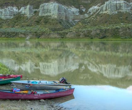
This section of the Smith River winds through diverse terrain as it approaches its meeting point with the Missouri River. The landscape transitions from the characteristic limestone canyons that define much of the Smith River's upper reaches to the broader, more open valleys typical of Missouri River country. Rolling hills covered in native grasslands stretch away from the riverbanks, punctuated by cottonwood groves and willow thickets that provide crucial habitat for wildlife.
The confluence itself marks a significant geographical point where the clear, cold waters of the Smith blend with the larger, more sediment-laden Missouri. This mixing zone creates unique conditions that support diverse aquatic life and provides excellent opportunities for observing the contrast between these two important Montana waterways.
Wildlife and Ecosystem
The Smith River confluence area supports an impressive array of wildlife typical of central Montana's riparian ecosystems. White-tailed deer and mule deer frequent the area, particularly during dawn and dusk hours when they come to drink. The diverse habitat supports both upland and waterfowl species, making it an excellent location for wildlife observation.
The river itself hosts healthy populations of native fish species, including mountain whitefish and various minnow species. The confluence zone, where the Smith meets the Missouri, creates particularly rich feeding areas that attract fish from both river systems. Birdlife is abundant, with great blue herons, belted kingfishers, and various raptors commonly spotted along the waterway.
Riparian vegetation plays a crucial role in maintaining the health of this ecosystem. Mature cottonwoods provide nesting sites for numerous bird species, while understory plants like wild rose, chokecherry, and various native grasses create habitat diversity that supports everything from small mammals to insects.
Access and Navigation
Reaching this remote section of the Smith River requires careful planning and preparation. The area's isolation is part of its appeal, but it also means that access points are limited and facilities are minimal. Most visitors approach the confluence area as part of longer river trips or overland expeditions.
The terrain can be challenging, with uneven ground, thick vegetation in places, and the need to navigate around wetland areas. Weather conditions can change rapidly, and the remote location means that self-sufficiency is essential. Visitors should be prepared for primitive conditions and pack accordingly.
Seasonal Considerations
Each season brings distinct characteristics to the Smith River confluence area. Spring typically brings higher water levels from snowmelt, creating dynamic conditions where the two rivers meet. The increased flow can make the confluence more dramatic and visible, but also potentially more challenging to navigate safely.
Summer offers the most stable conditions, with lower, clearer water that makes it easier to observe the distinct characteristics of each river system. This is often the preferred time for extended visits, though temperatures can be quite warm during midday hours.
Fall brings spectacular colors to the cottonwood groves and creates excellent wildlife viewing opportunities as animals prepare for winter. Water levels are typically stable, and cooler temperatures make for comfortable exploring conditions.
Winter access can be extremely challenging due to weather conditions and limited daylight, but the area takes on a stark beauty that appeals to hardy adventurers willing to face the elements.
What Makes This Area Special
The Smith River confluence stands out for its remarkable sense of isolation and pristine condition. Unlike many river confluences that have been developed or altered, this meeting point retains its natural character. The area offers a genuine wilderness experience that's becoming increasingly rare in the modern West.
The contrast between the two river systems creates fascinating opportunities for observation and photography. The Smith's typically clearer water meeting the Missouri's broader, more sediment-rich flow creates visible boundaries that shift and change with conditions.
For those seeking solitude and a connection with Montana's wild places, this area delivers an authentic experience. The remoteness that makes access challenging also ensures that visitors often have the area largely to themselves, creating opportunities for quiet reflection and undisturbed wildlife observation.
Planning Your Visit
Success in this remote area depends heavily on thorough preparation. Bring all necessary supplies, including plenty of water, food, first aid materials, and appropriate clothing for changing conditions. Communication devices like satellite communicators are strongly recommended given the area's isolation.
Weather can be unpredictable, so check current conditions and forecasts before departing. River levels can affect access and safety, particularly during spring runoff or after significant rainfall events.
Leave No Trace principles are especially important in this pristine environment. Pack out all waste, minimize impact on vegetation, and respect wildlife by observing from appropriate distances.
The Essential Hiking Checklist
Everything you need for your next hike. Bilingual, printable, 1 page.
Get your free hiking checklistRecommended gear for this trail
As an Amazon Associate I earn from qualifying purchases.


Ready to go?
Everything you need to know before you goWhen?
How much?
As an Amazon Associate I earn from qualifying purchases.
Affiliate links — LGPO may earn a commission at no extra cost to you.
- Hiking shoes Essential
- → Salomon Elixir Tour Mid WP · 203.38 $
- Layered clothing Essential
- Rain jacket Essential
- Trekking poles
- → Black Diamond Trail Ergo Cork · 69.99 $
- Headlamp
- → Petzl Actik Core 625 · 103.95 $
FAQ - Frequently asked questions
Everything you need to knowSimilar hikes nearby
Discover other trails you might enjoy

Hiking near Calgary
120 trails to explore ~479 km away
We work hard to provide the most up-to-date and error-free data possible. If something seems incorrect, let us know! Your contribution helps the whole community.
Hikers' opinions
Be the first to review!
No hiker has shared their experience yet. Share your impressions and help other hikers!