
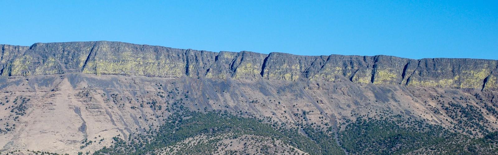

Ready to explore Abert Rim? Here's everything you need to know before you go!
Discover the trail
Oh no! We don't have any photos 😢
This trail hasn't been captured yet. Be the first to share your adventure!Trail description
Abert Rim in Lake County, Oregon is one of the highest fault scarps in the United States. It rises 2,490 feet (760 m) above the valley floor, finishing with a 820-foot (250 m) sheer-sided basalt cap. It was formed during the Miocene epoch. At that time basaltic flood lavas covered much of eastern Oregon. In subsequent faulting, great blocks were tilted and Abert Rim is at the western end of one of these blocks, while Lake Abert lies on top of another. Stretching more than 30 miles (48 km) from Lakeview north to Alkali Lake, Abert Rim is also the longest exposed fault scarp in North America.
Bighorn sheep were transplanted to the rim in 1975 and 1977 from nearby Hart Mountain, and are often spotted from the Abert Rim geologic point of interest sign located along Highway 395. Raptors, such as the Ferruginous Hawk, are also common in the area.
The Chewaucan River enters the lake from the south, however it has no outlet. The lake level varies depending on rainfall and it nearly completely dried up 140 years ago. It is one of the Great Basin lakes.
The escarpment and lake were first mapped on December 20, 1843, by John C. Frémont, who named it after Colonel John James Abert, his commanding officer.
The southern section of Abert Rim is a popular spot for hang gliding because of the frequent thermals created by warm valley air rising up against the cliffs. The area is considered by many to be the hang gliding capital of the West. National hang gliding festivals are held each year in late June and during the Fourth of July.
Free
1 pages
The Essential Hiking Checklist
Everything you need for your next hike. Bilingual, printable, 1 page.
Get your free hiking checklistRecommended gear for this trail
As an Amazon Associate I earn from qualifying purchases.
LGPO Pick

Salomon
Elixir Tour Mid WP
Waterproof mid-height boot ideal for rocky terrain
203.38 $


Affiliate links — LGPO may earn a commission at no extra cost to you.
Ready to go?
Everything you need to know before you goWhen?
Opening hours
No information
Varies by season
Best season
Fall
Spectacular colors
Best time
Early morning
Less crowded
Weather (next days)
Loading
How much?
Entry fees
Adult
Not available
Child
—
What to bring?
As an Amazon Associate I earn from qualifying purchases.
Affiliate links — LGPO may earn a commission at no extra cost to you.
Gear
- Hiking shoes Essential
- → Salomon Elixir Tour Mid WP · 203.38 $
- Layered clothing Essential
- Rain jacket Essential
- Trekking poles
- → Black Diamond Trail Ergo Cork · 69.99 $
- Headlamp
- → Petzl Actik Core 625 · 103.95 $
Water & food
2L minimum
No water point on the trail
Bring energy snacks for a 4h+ hike
Good to know
Safety
Download the GPX before you go
Limited cellular coverage on the trail
Slippery after rain
Be careful on rocky sections
In an emergency
Emergency
911
Parking GPS
42.5629, -120.173815
Center
Not available
FAQ - Frequently asked questions
Everything you need to knowAbert Rim is rated easy.
The elevation gain of Abert Rim is 41 m.
The summit of Abert Rim is at 195 m.
Allow about 30 min for Abert Rim (1.8 km).
No, Abert Rim has no visitor centre on site.
Didn't find your answer?
Similar hikes nearby
Discover other trails you might enjoy

Top 10 best hiking in Eastern Oregon
Our ranking based on hiker reviews
Hiking near Victoria
93 trails to explore ~698 km away
Did you spot an error?
We work hard to provide the most up-to-date and error-free data possible. If something seems incorrect, let us know! Your contribution helps the whole community.
Hikers' opinions
Be the first to review!
No hiker has shared their experience yet. Share your impressions and help other hikers!