
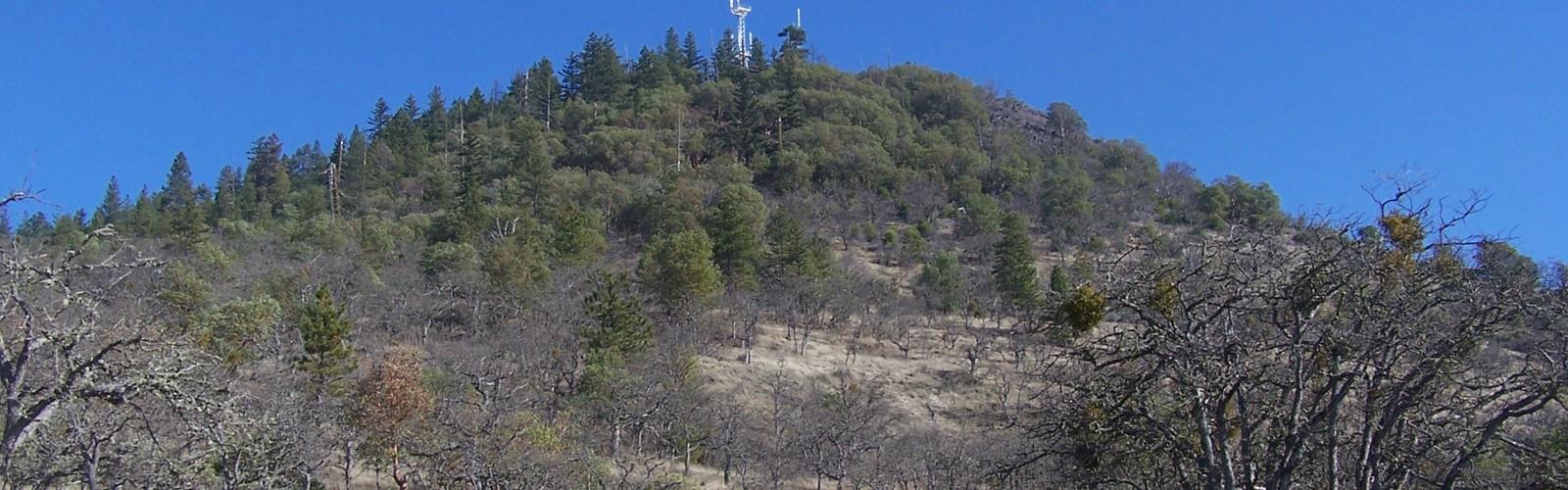

Ready to explore Roxy Ann Peak? Here's everything you need to know before you go!
Discover the trail
Oh no! We don't have any photos 😢
This trail hasn't been captured yet. Be the first to share your adventure!Trail description
Roxy Ann Peak is one of the most accessible and rewarding hikes in the Medford area of southern Oregon. Rising above the Rogue Valley, this prominent volcanic butte offers a network of trails that wind through oak woodlands, open chaparral, and rocky terrain — all within minutes of the city. Whether you're looking for a quick morning workout or a longer exploratory loop, Roxy Ann delivers a genuine outdoor experience without requiring a long drive.
The Terrain
The landscape on Roxy Ann Peak is distinctly southern Oregon. The lower slopes are dominated by Oregon white oak and manzanita, giving way to drier, more exposed terrain as you gain elevation. The rocky summit area offers a stark contrast to the valley floor below — open, windswept, and surprisingly rugged for a peak this close to an urban center. The trails themselves range from wide, well-maintained paths to narrower singletrack that cuts through dense brush. Footing is generally solid, though some sections feature loose rock and uneven ground that warrant a bit of attention.
The Prescott Park trail system — which covers the peak and surrounding land — is managed as a natural area, and that shows. The vegetation feels wild and largely undisturbed, with native shrubs and grasses filling in between the oaks. Birdlife is active throughout the area, and the open slopes make for good wildlife spotting if you're moving quietly.
The Views
The summit of Roxy Ann Peak is the clear highlight of any visit. From the top, you get a sweeping panoramic view of the Rogue Valley — Medford, Ashland, and the surrounding agricultural land spread out below, framed by the Cascade Range to the east and the Siskiyou Mountains to the south. On a clear day, Mount McLoughlin is a dominant presence on the horizon. It's the kind of view that makes the climb feel well worth it, and it's a popular spot to stop, eat lunch, and take in the scale of the valley.
Trail Network
One of the strengths of Roxy Ann Peak is the variety of routes available. The trail system offers multiple ways to reach the summit and several options for loops of different lengths. This makes it a flexible destination — you can tailor your outing based on how much time and energy you have. Trails are generally well-marked, though it's worth checking a current map before heading out, as the network has a number of intersections that can be confusing on a first visit.
- Summit access: Multiple routes lead to the top, with varying degrees of elevation gain and exposure.
- Loop options: The trail network supports several loop configurations, allowing you to vary your route on repeat visits.
- Connector trails: Shorter connector paths link the main routes and allow for more customized outings.
Who It's Good For
Roxy Ann Peak works well for a wide range of hikers. Locals use it regularly for fitness — the elevation gain makes it a solid cardio workout without being extreme. Families with older kids who are comfortable on uneven terrain will find it manageable. Trail runners are a common sight on the wider paths. It's also a good option for visitors to the Medford area who want a meaningful hike without committing to a full-day backcountry adventure.
Dogs are a frequent presence on the trails. If you're bringing a dog, check current regulations for the park regarding leash requirements before you go, as rules can vary by zone and season.
Practical Information
Roxy Ann Peak sits within Prescott Park, a natural area on the eastern edge of Medford. Access is straightforward, with a trailhead and parking area at the base of the peak. The area is popular on weekends, particularly on weekend mornings, so arriving early is a good idea if you want a parking spot without hassle.
- Location: Prescott Park, eastern Medford, Oregon
- Parking: Available at the main trailhead; can fill up on busy weekend mornings
- Fees: No fee information available — check with the City of Medford Parks and Recreation for current access details
- Dogs: Commonly seen on trails; verify current leash rules before visiting
- Bikes: Some trails in the network are open to mountain bikes — check current trail designations
Seasonal Considerations
The trails on Roxy Ann Peak are accessible for much of the year thanks to the relatively low elevation and the dry southern Oregon climate. Spring brings green hillsides and wildflowers on the open slopes. Summer gets hot — early morning starts are strongly recommended from June through September to avoid the midday heat on the exposed upper trails. Fall is a pleasant time to visit, with cooler temperatures and good visibility for the valley views. Winter is generally mild enough for hiking, though occasional snow or ice can affect the upper sections of the trail.
What Makes It Stand Out
What sets Roxy Ann Peak apart from other urban-adjacent hikes is the combination of genuine elevation gain, real views, and a trail network substantial enough to keep things interesting over multiple visits. It doesn't feel like a park path — it feels like a proper hike that happens to be five minutes from town. For residents of the Rogue Valley, it's a go-to spot that earns its reputation through consistent quality rather than novelty. For visitors, it's a reliable way to get a feel for the southern Oregon landscape without venturing far from the valley floor.
The Essential Hiking Checklist
Everything you need for your next hike. Bilingual, printable, 1 page.
Get your free hiking checklistRecommended gear for this trail
As an Amazon Associate I earn from qualifying purchases.


Ready to go?
Everything you need to know before you goWhen?
How much?
As an Amazon Associate I earn from qualifying purchases.
Affiliate links — LGPO may earn a commission at no extra cost to you.
- Hiking shoes Essential
- → Salomon Elixir Tour Mid WP · 203.38 $
- Layered clothing Essential
- Rain jacket Essential
- Trekking poles
- → Black Diamond Trail Ergo Cork · 69.99 $
- Headlamp
- → Petzl Actik Core 625 · 103.95 $
FAQ - Frequently asked questions
Everything you need to knowSimilar hikes nearby
Discover other trails you might enjoy

Hiking near Victoria
93 trails to explore ~676 km away
We work hard to provide the most up-to-date and error-free data possible. If something seems incorrect, let us know! Your contribution helps the whole community.
Hikers' opinions
Be the first to review!
No hiker has shared their experience yet. Share your impressions and help other hikers!