
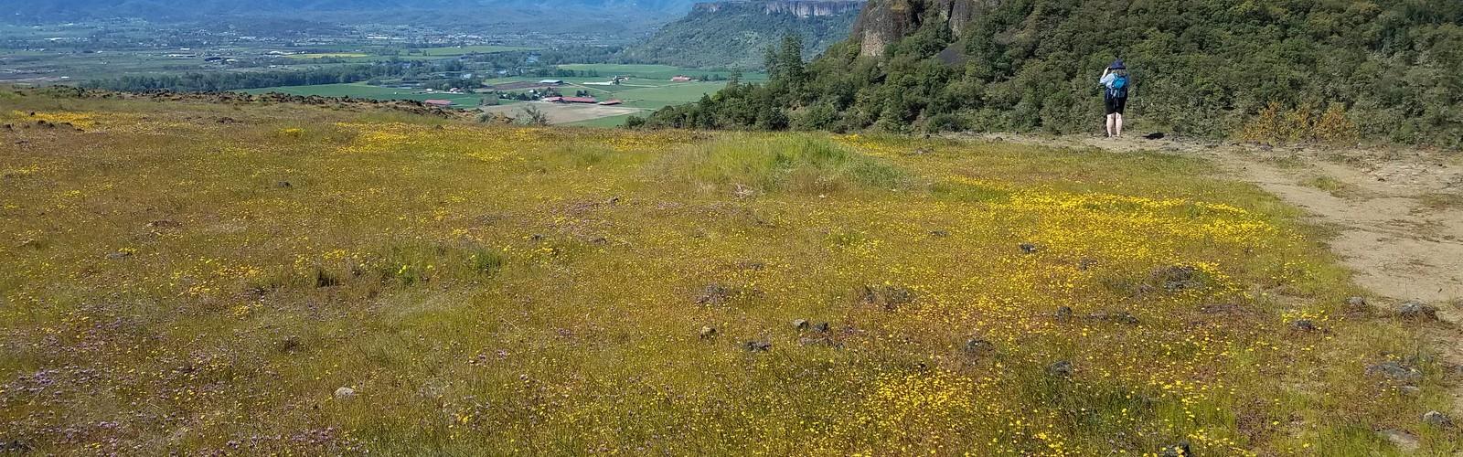

Ready to explore Upper Table Rock? Here's everything you need to know before you go!
Discover the trail
Oh no! We don't have any photos 😢
This trail hasn't been captured yet. Be the first to share your adventure!Trail description
Upper Table Rock is one of the most distinctive natural landmarks in the Rogue Valley area of southern Oregon. Rising dramatically above the surrounding landscape, this flat-topped mesa is the kind of place that stops you in your tracks the moment you spot it from the road. The hike to the top rewards you with sweeping views, rare wildflowers, and a geological story that goes back millions of years.
The Landscape
Upper Table Rock is a lava-capped mesa formed by ancient volcanic activity. The hard andesite cap that crowns the summit protected the softer rock beneath from erosion over millions of years, leaving behind this striking tabletop formation. The result is a landscape that feels genuinely unique — you're walking on the remnants of a lava flow that essentially froze time for the terrain underneath it.
The summit plateau is surprisingly expansive once you get up there. It's a broad, open tableland with a mix of vernal pools, native bunchgrass, and scattered Oregon white oak. In spring, those seasonal pools fill with water and become critical habitat for the endemic vernal pool fairy shrimp, a species found in very few places on Earth. The pools dry out as the season progresses, but the wildflower display that follows is genuinely impressive.
Flora and Wildlife
Upper Table Rock is recognized as a significant botanical site, and for good reason. The combination of volcanic soils, seasonal wetlands, and the mesa's relative isolation has created conditions for a remarkable concentration of native plant species. Spring is peak season for wildflowers, with camas, goldfields, and meadowfoam putting on a show across the plateau.
The area is also known for its population of the rare dwarf woolly meadowfoam, a plant found almost exclusively on Table Rock mesas. Birding is solid here as well — raptors are commonly spotted riding thermals above the cliffs, and the oak woodlands on the approach support a good variety of songbirds.
Keep an eye out for western fence lizards sunning themselves on the rocky outcrops near the rim. Black-tailed deer are frequently seen on the plateau, particularly in the early morning.
The Trail Experience
The trail to Upper Table Rock climbs steadily through oak woodland and chaparral before breaking out onto the open mesa. The ascent is the main physical challenge — the route gains elevation at a consistent grade before leveling off completely once you reach the top. Once you're on the plateau, the walking is easy and the views open up in all directions.
The rim offers dramatic drop-offs with views across the Rogue Valley, toward Lower Table Rock to the south, and into the surrounding foothills. It's worth taking your time up here and walking the perimeter of the plateau rather than just heading straight to the obvious viewpoints. The vernal pool areas are particularly worth seeking out in late winter and early spring.
The trail surface is a mix of packed dirt and rocky sections. Sturdy footwear is recommended, especially on the steeper portions of the climb. Trekking poles are helpful but not essential.
Conservation and Management
Upper Table Rock is managed through a partnership between The Nature Conservancy and the Bureau of Land Management. The Nature Conservancy has owned and protected portions of the Table Rocks area for decades, recognizing the exceptional ecological value of these mesas. Because of the sensitive nature of the vernal pool ecosystems and rare plant communities, staying on the designated trail is especially important here — the fragile soils and plant communities on the plateau are easily damaged by off-trail foot traffic.
Dogs are permitted on the trail but must be kept on leash at all times. This is strictly enforced given the wildlife and sensitive habitat on the plateau.
Practical Information
The trailhead for Upper Table Rock has a designated parking area with a vault toilet. The lot can fill up quickly on spring weekends, particularly when the wildflowers are at their peak — arriving early in the morning is the best strategy if you want to avoid the crowds and snag a parking spot without hassle.
There is no fee to hike Upper Table Rock. The trail is open year-round, though conditions vary significantly by season. Summer can be hot and exposed on the plateau, so carrying plenty of water is essential. Spring offers the best combination of comfortable temperatures, wildflowers, and active vernal pools. Winter hikes are possible and often quiet, but the trail can be muddy and slippery after rain.
- Fees: No fee required
- Dogs: Allowed on leash
- Bikes: Not permitted on the trail
- Facilities: Vault toilet at the trailhead
- Best season: Spring for wildflowers and vernal pools; accessible year-round
- Managed by: The Nature Conservancy and Bureau of Land Management
What Makes Upper Table Rock Stand Out
There are plenty of good hikes in the Rogue Valley, but Upper Table Rock occupies a category of its own. The combination of dramatic geology, rare endemic species, and genuinely panoramic summit views makes it one of the more memorable day hikes in southern Oregon. The fact that it protects habitat found almost nowhere else on the planet gives the place a weight that goes beyond just the scenery. Whether you're coming for the wildflowers, the views, or just a solid half-day outing, Upper Table Rock consistently delivers.
The Essential Hiking Checklist
Everything you need for your next hike. Bilingual, printable, 1 page.
Get your free hiking checklistRecommended gear for this trail
As an Amazon Associate I earn from qualifying purchases.


Ready to go?
Everything you need to know before you goWhen?
How much?
As an Amazon Associate I earn from qualifying purchases.
Affiliate links — LGPO may earn a commission at no extra cost to you.
- Hiking shoes Essential
- → Salomon Elixir Tour Mid WP · 203.38 $
- Layered clothing Essential
- Rain jacket Essential
- Trekking poles
- → Black Diamond Trail Ergo Cork · 69.99 $
- Headlamp
- → Petzl Actik Core 625 · 103.95 $
FAQ - Frequently asked questions
Everything you need to knowSimilar hikes nearby
Discover other trails you might enjoy

Hiking near Victoria
93 trails to explore ~664 km away
We work hard to provide the most up-to-date and error-free data possible. If something seems incorrect, let us know! Your contribution helps the whole community.
Hikers' opinions
Be the first to review!
No hiker has shared their experience yet. Share your impressions and help other hikers!