

Ready to explore Bread Loaf Mountain, Vermont? Here's everything you need to know before you go!
Discover the trail


Trail description
Description
Bread Loaf Mountain is one of those summits in Vermont's Green Mountains that rewards the effort without demanding you be a seasoned alpinist to get there. Tucked within the Green Mountain National Forest in central Vermont, this peak sits in a landscape shaped by glaciers, hardwood forests, and the kind of quiet that's getting harder to find. If you're looking for a hike that feels genuinely wild without being a sufferfest, Bread Loaf Mountain delivers.
The Terrain
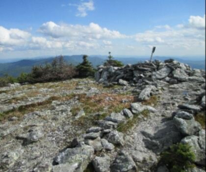
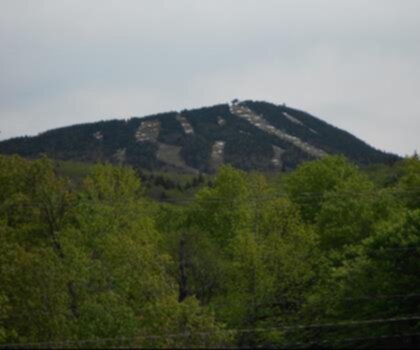
The mountain takes its name from its distinctive rounded profile — from certain angles, it does bear a passing resemblance to a loaf of bread rising above the surrounding ridgeline. The approach moves through classic Vermont forest: northern hardwoods lower on the slope giving way to spruce and fir as you gain elevation. The trail underfoot is typical Green Mountain fare — rooted, occasionally muddy in spring and after rain, with rocky sections near the upper reaches. Trekking poles are worth bringing if you have them.
The summit area sits within a broader ridge system that connects to other high points in the region, giving the landscape a layered, rolling quality rather than a sharp, dramatic peak. Views from the top open up through the trees in places, offering glimpses of the surrounding Green Mountain terrain. This is not a bald summit with a 360-degree panorama — it's a forested high point with earned, partial views that feel more intimate than spectacular.
What Makes This Hike Stand Out
Bread Loaf Mountain sits in a part of Vermont that doesn't get the same foot traffic as the more famous summits further north or south along the Long Trail corridor. That relative obscurity is actually one of its strongest selling points. On a weekend when Camel's Hump or Mount Mansfield are packed, you can find genuine solitude here. The Green Mountain National Forest setting means the land is managed for multiple uses, but the hiking experience remains quiet and natural.
The area around Bread Loaf is also historically interesting. The Bread Loaf campus of Middlebury College — the famous literary conference site — sits nearby in the valley, lending the whole area a certain cultural character that's unique in Vermont's mountain landscape. The mountain itself, though, is all forest and trail.
Wildlife and Natural Environment
The forests here support the full range of wildlife you'd expect in Vermont's Green Mountains. Black bear, white-tailed deer, moose, and a variety of bird species including thrushes, warblers, and raptors are all part of the ecosystem. The transition from hardwood to boreal forest as you climb is worth paying attention to — it's a good reminder of how much changes over a relatively short vertical distance in Vermont's mountains.
Wildflowers are present along the trail in spring and early summer, particularly in the lower forest sections. The forest floor in the spruce-fir zone near the summit has that characteristic cushioned, mossy quality that makes the upper mountain feel distinctly different from the approach.
Practical Information
Bread Loaf Mountain is located within the Green Mountain National Forest in Vermont. Access and trail conditions can vary by season, and the area is subject to the general regulations of the National Forest. As with most Vermont mountain trails, mud season — roughly mid-April through Memorial Day — can make the trail significantly more difficult and damaging to the surface. Hiking outside of mud season is strongly encouraged.
- Location: Green Mountain National Forest, Vermont
- Land manager: USDA Forest Service, Green Mountain National Forest
- Best seasons: Late spring through fall, once mud season has passed
- Winter use: The trail can be hiked in winter with appropriate footwear and gear; snowshoes or microspikes are typically needed
- Dogs: Permitted on National Forest lands; keep under control and pack out waste
Getting There
Bread Loaf Mountain is accessed from the Bread Loaf area of the Green Mountain National Forest in Addison County, Vermont. The nearest significant town is Middlebury, which sits to the west in the Champlain Valley. Route 125 runs through the Bread Loaf area and serves as the main access corridor. Trailhead parking is available in the National Forest; check current conditions and access details with the Green Mountain National Forest before heading out, as road and trailhead access can change seasonally.
Tips for Your Visit
- Start early: Even on less-trafficked trails, an early start gives you the best conditions and the most flexibility if the hike takes longer than expected.
- Check the weather: Vermont mountain weather can shift quickly. The summit area can be significantly cooler and windier than the trailhead, so layer up.
- Footwear matters: Waterproof hiking boots are the right call here. The trail can be wet and rooted, and ankle support is useful on the rocky upper sections.
- Leave No Trace: The Green Mountain National Forest is a shared resource. Stay on trail, pack out everything you bring in, and respect the forest.
- Cell service: Don't count on it. Download offline maps before you go and let someone know your plan.
Who This Hike Is For
Bread Loaf Mountain suits hikers who are comfortable on rooted, uneven Vermont forest trails and are looking for a quieter alternative to the Green Mountains' more famous peaks. It's a good fit for those who appreciate the journey through the forest as much as the destination at the top. Families with older kids who have some trail experience, fit adults looking for a half-day or full-day outing, and anyone who values solitude over summit crowds will find this hike genuinely satisfying.
If you're new to Vermont hiking or coming from a flat-terrain background, be prepared for the trail character — rooted, rocky, and occasionally steep — that defines hiking in the Green Mountains, and plan your pace accordingly.
Recommended gear for this trail


Ready to go?
Everything you need to know before you goStarting Point
The start of the trails at the bread loaf mountain, Vermont can be accessed by traveling east on Route 125 from Ripton, Vermont. The trailhead is located on the left side of the road just past the junction with Route 125A.
When?
How much?
- Hiking shoes Essential
- → Salomon Elixir Tour Mid WP · 203.38 $
- Layered clothing Essential
- Rain jacket Essential
- Trekking poles
- → Black Diamond Trail Ergo Cork · 69.99 $
- Headlamp
- → Petzl Actik Core 625 · 103.95 $
FAQ - Frequently asked questions
Everything you need to knowThe Essential Hiking Checklist
Everything you need for your next hike. Bilingual, printable, 1 page.
Download the free checklistSimilar hikes nearby
Discover other trails you might enjoy
Mount Abraham, Vermont
Green Mountains
Snowdon Peak, Vermont
Green Mountains

Slate Valley Trails
Green Mountains
Flatlander Farm
Green Mountains
Bristol Tripadvisor #1, Vermont Bed and Breakfast at Russell Young Farm
Green Mountains
Deer Leap Trail
Green Mountains
Hiking near Montpelier
0 trails to explore ~41 km away
We work hard to provide the most up-to-date and error-free data possible. If something seems incorrect, let us know! Your contribution helps the whole community.
Hikers' opinions