

Ready to explore Dorset Mountain, Vermont? Here's everything you need to know before you go!
Discover the trail


Trail description
Description
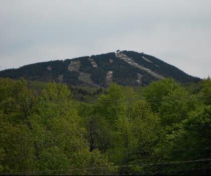
Dorset Mountain sits quietly in the Green Mountains of Vermont, offering a rewarding hiking experience that feels genuinely off the beaten path. While it doesn't carry the same name recognition as some of Vermont's more famous summits, that's actually part of its appeal — you're more likely to share the trail with a handful of locals than a crowd of weekend warriors.
The Terrain
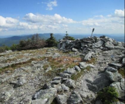
The mountain is characteristic of the southern Green Mountains — forested slopes, rocky footing in places, and a mix of hardwoods and conifers that shift as you gain elevation. The trail winds through a landscape that feels unhurried and genuinely wild. Underfoot, expect roots, loose rock, and the kind of uneven ground that keeps you paying attention. This isn't a groomed path, and that's exactly what makes it satisfying.
The forest here is dense enough to provide good shade on warm days, and the canopy opens up at key moments along the route. The Green Mountains in this part of Vermont are known for their marble geology — Dorset itself sits in a region historically significant for its marble quarrying, and that geological character shapes the landscape in subtle but noticeable ways.
What to Expect on the Trail
Dorset Mountain rewards hikers who don't need a summit selfie to feel like the effort was worth it. The experience is about the walk itself — the quality of the forest, the gradual climb, the sense of being genuinely away from things. Views, where they exist, tend to be earned rather than handed to you.
The trail is not heavily signed or developed, so it's worth doing a bit of homework before you go. Bring a map, pay attention to trail markers, and don't rely solely on a phone signal to navigate. That said, the route is manageable for hikers with reasonable trail experience who are comfortable with natural, unmarked terrain.
The Green Mountains Context
Dorset Mountain is part of the broader Green Mountains range, which forms the spine of Vermont. This range is home to the Long Trail — the oldest long-distance hiking trail in the United States — and the hiking culture here runs deep. Even on smaller, less-trafficked peaks like Dorset Mountain, you're stepping into a landscape that Vermonters have been exploring on foot for generations.
The area around Dorset is also known for its pastoral character — classic Vermont village scenery, open meadows, and the kind of quiet that's increasingly hard to find. The contrast between the village of Dorset below and the forested slopes above makes the approach to the trailhead feel like a genuine transition into the backcountry.
Practical Information
- Trail character: Natural, forested terrain with rocky and rooted sections — standard Green Mountains hiking conditions.
- Navigation: The trail is not heavily developed; carry a paper map or downloaded offline map as a backup.
- Footwear: Sturdy hiking boots with ankle support are recommended given the uneven terrain.
- Season: Vermont's mud season (typically mid-April through late May) can make trails slippery and prone to erosion — check local conditions before heading out during this window.
- Leave No Trace: Stay on established trails to protect the surrounding forest and minimize impact on the landscape.
Getting There
Dorset Mountain is located in Dorset, Vermont, in Bennington County in the southwestern part of the state. The village of Dorset is accessible via Route 30, which runs through the valley and connects to the broader Vermont road network. Trailhead access and parking details are worth confirming locally before your visit, as conditions and access points can vary.
Who This Hike Is For
Dorset Mountain is a solid choice for hikers who want a genuine Green Mountains experience without the crowds that come with more prominent Vermont summits. It suits people who are comfortable on natural terrain, don't need heavy infrastructure, and appreciate a quieter, more self-reliant style of hiking. If you're traveling through southwestern Vermont and want to get into the hills for a few hours, this is a worthwhile detour that delivers the real character of the region.
Recommended gear for this trail


Ready to go?
Everything you need to know before you goStarting Point
To access the hiking trails, you can start at one of the following trailheads:
Long Trail/Appalachian Trail Parking Area: Located on Route 30/11, this parking area provides access to the trail network. The address is approximately 2 miles east of Manchester Center.
Dorset Quarry Parking Lot: Situated near the intersection of Route 30 and Dorset West Road, this lot offers another entry point to the trails.
Ensure you check local maps or guides for specific directions and trail conditions before heading out.
When?
How much?
- Hiking shoes Essential
- → Salomon Elixir Tour Mid WP · 203.38 $
- Layered clothing Essential
- Rain jacket Essential
- Trekking poles
- → Black Diamond Trail Ergo Cork · 69.99 $
- Headlamp
- → Petzl Actik Core 625 · 103.95 $
FAQ - Frequently asked questions
Everything you need to knowThe Essential Hiking Checklist
Everything you need for your next hike. Bilingual, printable, 1 page.
Download the free checklistSimilar hikes nearby
Discover other trails you might enjoy
Mount Abraham, Vermont
Green Mountains
Snowdon Peak, Vermont
Green Mountains

Slate Valley Trails
Green Mountains
Flatlander Farm
Green Mountains
Bristol Tripadvisor #1, Vermont Bed and Breakfast at Russell Young Farm
Green Mountains
Deer Leap Trail
Green Mountains
Hiking near Saratoga Springs
0 trails to explore ~66 km away
We work hard to provide the most up-to-date and error-free data possible. If something seems incorrect, let us know! Your contribution helps the whole community.
Hikers' opinions