

Ready to explore Glen Lake? Here's everything you need to know before you go!
Discover the trail
Oh no! We don't have any photos 😢
This trail hasn't been captured yet. Be the first to share your adventure!Trail description
Description
Glen Lake is a peaceful hiking destination tucked into the Green Mountains of Vermont. Whether you're looking for a quiet morning walk near the water or a spot to slow down and take in the natural surroundings, this trail delivers a genuine Vermont outdoor experience without a lot of fuss. It's the kind of place that doesn't need to oversell itself — the lake does the talking.
The Setting
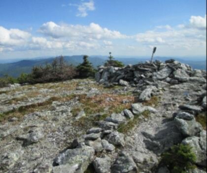
The trail follows the shoreline of Glen Lake, weaving through the kind of mixed forest that defines this part of Vermont. You'll move through stands of hardwoods and conifers, with the lake appearing and disappearing through the trees as you go. The terrain stays close to the water for much of the route, which means you get regular views across the surface without having to work too hard for them.
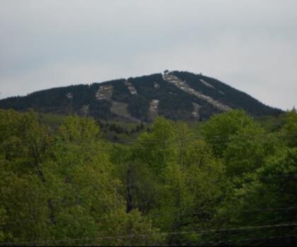
The Green Mountains provide the backdrop here, and the landscape has that layered, textured feel that makes Vermont hiking so satisfying. The forest floor is dense with ferns and mosses, and the trail itself has a natural, well-worn character — this isn't a manicured path, but it's clearly traveled and easy enough to follow.
What to Expect on the Trail
The trail around Glen Lake is well-suited to hikers who want to enjoy the environment without pushing hard. The route stays relatively close to the lakeshore, so elevation changes are modest and the pace tends to be relaxed. That said, the terrain underfoot can be rooty and uneven in spots, so solid footwear is still a good idea — trail runners or light hiking boots will serve you well.
The lake itself is the main draw. On calm mornings, the water reflects the surrounding hills and trees in a way that makes it worth pausing frequently. If you're the type to stop and watch for wildlife, this is a good spot for it — the shoreline habitat supports a variety of bird species, and the quieter sections of trail give you a real chance to observe without disturbing much.
Wildlife and Natural Features
Glen Lake sits within the broader Green Mountain ecosystem, which means the surrounding forest supports a healthy mix of wildlife. Keep your eyes and ears open as you hike — the transition zones between forest and water are particularly active. Waterfowl are commonly spotted on the lake, and the wooded sections of trail are good for songbirds, especially during the warmer months.
The vegetation along the trail reflects the character of Vermont's northern hardwood forests. Maple, beech, and birch are common, along with hemlock in the shadier, moister sections closer to the water. In spring, the understory comes alive with wildflowers before the canopy closes in. By fall, the foliage here is exactly what you'd hope for from a Vermont trail — rich, layered color that makes even a short hike feel like an event.
Practical Information
Glen Lake is located in the Green Mountains region of Vermont. Access and parking details are worth confirming before your visit, as trailhead facilities in this area can vary. Arriving early on weekends is generally a smart move — popular Vermont hiking destinations tend to fill up, particularly during fall foliage season and summer weekends.
- Footwear: Trail runners or hiking boots recommended — the path can be rooty and uneven near the shoreline.
- Timing: Early morning visits offer the calmest lake conditions and the best wildlife activity.
- Seasons: The trail is accessible across multiple seasons, though spring can bring muddy conditions and late fall may see limited daylight for longer loops.
- Leave No Trace: Stay on the established trail, especially near the water's edge, to protect the shoreline habitat.
Who This Trail Is For
Glen Lake works well for a wide range of hikers. Families with kids who are comfortable on natural terrain will find the lakeshore setting engaging without the trail being too demanding. Photographers and birders will appreciate the access to the water and the variety of habitat along the route. And if you're a more experienced hiker looking for a lower-key day — maybe a recovery hike between bigger objectives in the Green Mountains — Glen Lake fits that role nicely too.
It's also a solid option if you're visiting Vermont and want something that captures the essence of the region without requiring a full-day commitment. The combination of forest, water, and mountain backdrop gives you a genuine taste of what makes this part of New England worth exploring on foot.
Tips for Making the Most of Your Visit
Bring water and a snack even if you're planning a shorter outing — it's easy to linger at the lake longer than expected, especially if the conditions are good. A pair of binoculars is worth tossing in your pack if you have them, given the wildlife activity along the shoreline. Bug repellent is a practical addition during the warmer months, particularly near the water.
If you're visiting during peak foliage season, plan for more company on the trail than you might expect — Glen Lake's setting makes it a natural draw when the colors are at their best in the Green Mountains. Weekday visits during that window will give you a noticeably quieter experience.
Cell service can be limited in this part of Vermont, so downloading an offline map before you head out is a straightforward precaution that's easy to overlook and occasionally very useful.
Recommended gear for this trail


Ready to go?
Everything you need to know before you goStarting Point
The glen lake trails are located in the town of Bolton, Vermont. To get to the start of the trails, take exit 8 off of I-89 and head east on VT-11. The trailhead is located at the end of VT-11.
When?
How much?
- Hiking shoes Essential
- → Salomon Elixir Tour Mid WP · 203.38 $
- Layered clothing Essential
- Rain jacket Essential
- Trekking poles
- → Black Diamond Trail Ergo Cork · 69.99 $
- Headlamp
- → Petzl Actik Core 625 · 103.95 $
FAQ - Frequently asked questions
Everything you need to knowThe Essential Hiking Checklist
Everything you need for your next hike. Bilingual, printable, 1 page.
Download the free checklistSimilar hikes nearby
Discover other trails you might enjoy
Mount Abraham, Vermont
Green Mountains
Snowdon Peak, Vermont
Green Mountains

Slate Valley Trails
Green Mountains
Flatlander Farm
Green Mountains
Bristol Tripadvisor #1, Vermont Bed and Breakfast at Russell Young Farm
Green Mountains
Deer Leap Trail
Green Mountains
Hiking near Saratoga Springs
0 trails to explore ~78 km away
We work hard to provide the most up-to-date and error-free data possible. If something seems incorrect, let us know! Your contribution helps the whole community.
Hikers' opinions