

Ready to explore Green Mountain, Vermont? Here's everything you need to know before you go!
Discover the trail
Oh no! We don't have any photos 😢
This trail hasn't been captured yet. Be the first to share your adventure!Trail description
Description
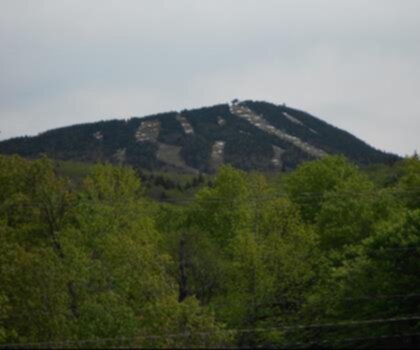
The Green Mountains of Vermont are one of the most rewarding climbing and hiking destinations in the northeastern United States. Running like a spine down the center of the state, this ancient mountain range offers a mix of rugged terrain, dense forest, and open ridgelines that draw outdoor enthusiasts from across the region. Whether you're lacing up for a technical scramble or a long ridge walk, the Green Mountains deliver a genuine backcountry feel without requiring you to travel to more remote wilderness areas.
The Terrain
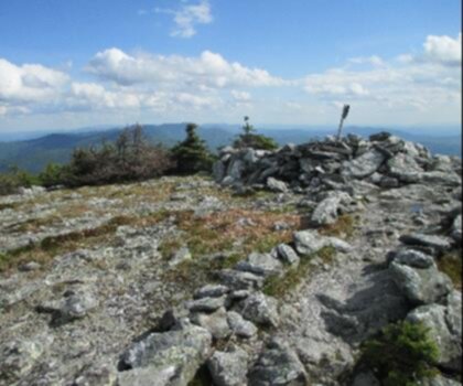
The Green Mountains are geologically old — far older than the Rockies — and that age shows in the landscape. The peaks are rounded by millennia of erosion, but don't let that fool you. The trails here can be steep, rocky, and demanding. Exposed quartzite and schist surfaces are common on the upper sections of many routes, and the rock tends to be grippy when dry but can become slick quickly in wet conditions. Roots and loose stones are constant companions on the lower forested sections, so solid footwear is a must.
Above treeline, the views open up across rolling forested ridges, valley farmland, and on clear days, distant peaks in neighboring states. The transition from dense northern hardwood and boreal forest to open alpine zones is one of the defining experiences of climbing in this range.
What Makes Green Mountain Climbing Distinct
What sets the Green Mountains apart from other northeastern ranges is the combination of accessibility and genuine wilderness character. The trails here aren't manicured resort paths — they're maintained by dedicated trail crews and volunteer organizations, but they retain a raw, natural feel. You'll find yourself navigating boulder fields, crossing streams on stepping stones, and pushing through sections of dense spruce-fir forest where the canopy closes in tight.
The range also has a deep hiking culture rooted in the Long Trail, the oldest long-distance hiking trail in the United States, which runs the full length of Vermont along the Green Mountain ridgeline. Even if you're not tackling the full trail, that history and infrastructure shape the entire climbing experience in this region — well-placed shelters, clearly marked routes, and a community of hikers who take stewardship seriously.
Wildlife and Natural Environment
The forests of the Green Mountains support a rich variety of wildlife. Black bears, moose, white-tailed deer, and a wide range of bird species are all present throughout the range. Higher elevations host boreal species more commonly associated with Canada, including Bicknell's thrush, a rare bird that nests almost exclusively in the high-elevation spruce-fir forests of the northeastern mountains. The alpine and sub-alpine zones are ecologically sensitive, and staying on marked trails in these areas is important for protecting fragile vegetation.
Wildflowers are abundant in spring and early summer, particularly in open meadows and along stream corridors. Fall brings some of the most spectacular foliage in New England, making late September and early October a peak season for visitors.
Practical Information
The Green Mountains span a large area, and access points vary depending on which section of the range you're exploring. Many trailheads are accessible from Route 4, Route 9, and Route 100, which run through or alongside the mountains. Parking areas at popular trailheads can fill up early on weekends, especially during foliage season and summer, so arriving early in the morning is a good strategy.
The Green Mountain National Forest manages much of the land in this range, and most trails are free to access. Some specific areas and facilities may have fees or permit requirements, so it's worth checking current conditions with the U.S. Forest Service before heading out. Cell service is limited to nonexistent on most trails, so downloading offline maps or carrying a paper map is strongly recommended.
Conditions and Seasonal Considerations
Vermont weather is famously unpredictable, and the Green Mountains generate their own microclimate. Temperatures at higher elevations can be significantly cooler than in the valleys, and afternoon thunderstorms are common in summer. Carrying rain gear regardless of the morning forecast is standard practice here.
Spring hiking in the Green Mountains comes with mud season — typically mid-March through May — when trails can be severely degraded by wet conditions. Many trail organizations ask hikers to avoid certain routes during this period to prevent lasting damage to the tread. Winter and early spring also bring ice and snow to higher elevations, requiring microspikes or crampons for safe travel.
Summer and fall are the prime seasons for most hikers. Trails are generally in their best condition from late June through October, with fall offering the added bonus of cooler temperatures and brilliant foliage.
Who This Is For
The Green Mountains offer something for a wide range of experience levels. Shorter, lower-elevation trails are suitable for hikers looking for a half-day outing with manageable terrain. The higher peaks and longer ridge routes are better suited to hikers with solid fitness and experience navigating rocky, rooted trails. Technical rock climbing is also present in certain areas of the range, adding another dimension for those looking to get vertical in a more literal sense.
If you're new to the area, connecting with local hiking clubs or checking in with the Green Mountain Club — the organization that built and maintains the Long Trail — is a great way to get current trail conditions and route recommendations tailored to your experience level.
Leave No Trace
The Green Mountains see significant visitor pressure, particularly on the most popular peaks and during peak seasons. Staying on marked trails, packing out all waste, and avoiding camping outside of designated sites helps protect the range for future visitors. Campfires are restricted in many areas, and above-treeline camping is generally discouraged to protect fragile alpine ecosystems. Following Leave No Trace principles isn't just good practice here — it's essential to keeping these trails in good shape for everyone who comes after you.
Recommended gear for this trail


Ready to go?
Everything you need to know before you goStarting Point
To access the hiking trails, you can start at several trailheads. Here are some options:
Appalachian/Long Trail Parking Lot: Located on Route 4, just east of Killington, VT. This is a popular starting point for accessing the trails.
Camel's Hump State Park: The Monroe Trailhead is located at Camel's Hump Road, Duxbury, VT 05676. This provides access to various trails in the area.
Mount Mansfield: The Underhill State Park offers a trailhead at 352 Mountain Road, Underhill Center, VT 05490.
Smugglers' Notch State Park: Access via the parking area on Route 108, near Stowe, VT.
These locations provide convenient access to explore the hiking opportunities available in the region.
When?
How much?
- Hiking shoes Essential
- → Salomon Elixir Tour Mid WP · 203.38 $
- Layered clothing Essential
- Rain jacket Essential
- Trekking poles
- → Black Diamond Trail Ergo Cork · 69.99 $
- Headlamp
- → Petzl Actik Core 625 · 103.95 $
FAQ - Frequently asked questions
Everything you need to knowThe Essential Hiking Checklist
Everything you need for your next hike. Bilingual, printable, 1 page.
Download the free checklistSimilar hikes nearby
Discover other trails you might enjoy
Mount Abraham, Vermont
Green Mountains
Snowdon Peak, Vermont
Green Mountains

Slate Valley Trails
Green Mountains
Flatlander Farm
Green Mountains
Bristol Tripadvisor #1, Vermont Bed and Breakfast at Russell Young Farm
Green Mountains
Deer Leap Trail
Green Mountains
Hiking near Saratoga Springs
0 trails to explore ~75 km away
We work hard to provide the most up-to-date and error-free data possible. If something seems incorrect, let us know! Your contribution helps the whole community.
Hikers' opinions