

Ready to explore Little Killington, Vermont? Here's everything you need to know before you go!
Discover the trail
Trail description
Description
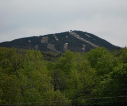
Little Killington is one of those summits that often gets overlooked simply because its more famous neighbor — Killington Peak — tends to steal all the attention. But that's exactly what makes it worth your time. This is a quieter, more contemplative corner of Vermont's Green Mountains, where the trail experience feels earned without being overwhelming, and the views remind you why people have been hiking this range for generations.
The Terrain
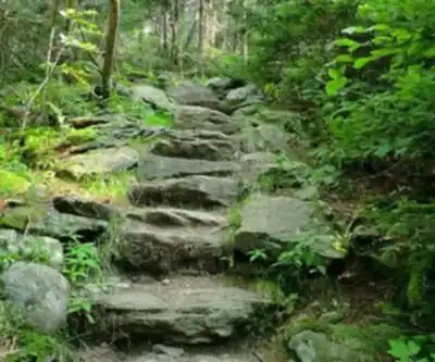
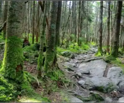
Little Killington sits within the Green Mountains of Vermont at an elevation of 3,939 feet (1,194 meters), a landscape defined by dense northern hardwood and boreal forest, rocky ridgelines, and the kind of rugged, rooted trail surface that keeps you honest about your footing. The approach involves a steady climb through mixed forest — expect spruce, fir, and birch as you gain elevation — with the trail becoming progressively more exposed and rocky as you near the upper reaches. Most routes feature approximately 1,201 meters (3,940 feet) of elevation gain depending on your starting point and chosen trail network.
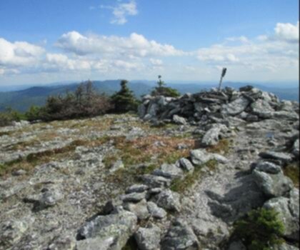
The forest here has real character. Lower sections tend to be shaded and mossy, with the trail weaving between boulders and tree roots. Higher up, the canopy opens and the terrain shifts to the kind of open, windswept ridge environment that defines the upper Green Mountains. The transition between these two zones is one of the more satisfying parts of the hike — you feel the mountain change around you as you climb.
What to Expect on the Trail
The trail to Little Killington is part of the broader network that threads through this section of the Green Mountain National Forest, including connections to the Long Trail — Vermont's iconic end-to-end footpath that runs the length of the state along the spine of the Green Mountains. Hikers familiar with Long Trail conditions will recognize the terrain: rooted, sometimes muddy, occasionally steep, and always rewarding.
Footing demands attention throughout. The trail surface is typical of Vermont's high-elevation routes — loose rock, exposed roots, and sections that can be slick after rain or during shoulder seasons when frost and mud are both possible. Trekking poles are a smart call, especially on the descent.
The summit area of Little Killington offers views that open up meaningfully once you clear the treeline. The perspective here is distinct from Killington Peak's more developed summit — there's no gondola, no ski infrastructure in your sightline, just the ridgeline and the rolling Green Mountain landscape stretching out around you. On a clear day, the views are genuinely expansive.
How Little Killington Fits Into the Larger Area
One of the things that makes Little Killington interesting as a destination is its relationship to the surrounding terrain. It's not an isolated peak — it's part of a connected ridge system that includes Killington Peak and the broader network of trails managed in this section of the Green Mountains. This means you have real options when planning your route.
Many hikers combine Little Killington with a push to Killington Peak itself, making for a longer day with more elevation gain and a more complete sense of the ridgeline. Others use Little Killington as a destination in its own right, particularly those who want a meaningful summit experience without the crowds that Killington Peak can attract, especially during peak foliage season in fall.
The Long Trail corridor runs through this area, which means you may share the trail with through-hikers and section hikers moving along Vermont's backbone. That's part of the culture of hiking in the Green Mountains — there's a sense of being part of something larger, a long tradition of foot travel through this landscape.
Seasons and Conditions
Vermont's Green Mountains have a compressed hiking season compared to lower-elevation destinations. Summer and fall are the prime windows. Fall foliage in this part of Vermont is exceptional — the hardwood forest lights up in a way that makes even familiar trails feel new, and the views from the upper ridge take on a different quality when the canopy below is orange and red.
Spring hiking in this area requires caution. Vermont's mud season is real, and high-elevation trails like those approaching Little Killington can be deeply rutted and soft well into May. Hiking on saturated trails causes lasting damage to the trail surface, so checking current conditions before heading out in spring is genuinely important, not just a formality.
Winter access is possible for those with the right gear and experience — snowshoes or microspikes depending on conditions — but the upper ridge can be exposed and cold, and route-finding requires more attention when the trail is snow-covered.
Practical Notes
- Trail network: Little Killington is accessible via trails that connect to the Long Trail system in the Green Mountain National Forest. Multiple approach routes are available via Long Trail and Upper Cold River Road. Familiarize yourself with the specific approach route before heading out.
- Elevation: Summit elevation 3,939 feet (1,194 m); typical elevation gain 1,201 meters depending on route selection.
- Difficulty: Routes range from easy to moderate depending on selected trail approach.
- Footing: Rocky, rooted trail surface throughout. Sturdy hiking footwear with ankle support is recommended. Trekking poles are useful, particularly on descent.
- Weather: Conditions on the upper ridge can change quickly. The Green Mountains are known for fast-moving weather systems, and the summit area is exposed. Bring layers and rain gear regardless of the forecast.
- Leave No Trace: This is a well-traveled area within a beloved Vermont hiking corridor. Stay on marked trails, pack out everything you bring in, and be mindful of other users on the trail.
- Navigation: A trail map of the Killington area and familiarity with the Long Trail in this section will help you plan your route and understand your options on the ground.
Who This Hike Is For
Little Killington rewards hikers who are comfortable on rocky, rooted Vermont terrain and who are looking for a genuine mountain experience without the infrastructure and crowds that come with Killington Peak's developed summit. If you've hiked in the Green Mountains before and want to explore a quieter corner of a well-known area, this is a strong choice. If you're newer to Vermont hiking, it's worth building some experience on lower-elevation trails first — the terrain here is unforgiving of poor footwear or underestimating the conditions.
What you get at Little Killington is the real Green Mountains experience: a forested climb, a rocky ridgeline, open views, and the quiet satisfaction of a summit that you reached on your own terms.
Recommended gear for this trail


Ready to go?
Everything you need to know before you goStarting Point
To access the hiking trails, you can start at the Brewer's Corner trailhead. The parking lot is located on Wheelerville Road, Mendon, VT 05701. Another option is to begin at the Bucklin Trailhead, which can be found at 2295 Wheelerville Road, Mendon, VT 05701. Both trailheads provide convenient access to the area’s hiking routes.
When?
How much?
- Hiking shoes Essential
- → Salomon Elixir Tour Mid WP · 203.38 $
- Layered clothing Essential
- Rain jacket Essential
- Trekking poles
- → Black Diamond Trail Ergo Cork · 69.99 $
- Headlamp
- → Petzl Actik Core 625 · 103.95 $
FAQ - Frequently asked questions
Everything you need to knowThe Essential Hiking Checklist
Everything you need for your next hike. Bilingual, printable, 1 page.
Download the free checklistSimilar hikes nearby
Discover other trails you might enjoy
Mount Abraham, Vermont
Green Mountains
Snowdon Peak, Vermont
Green Mountains

Slate Valley Trails
Green Mountains
Flatlander Farm
Green Mountains
Bristol Tripadvisor #1, Vermont Bed and Breakfast at Russell Young Farm
Green Mountains
Deer Leap Trail
Green Mountains
Hiking near Montpelier
0 trails to explore ~77 km away
We work hard to provide the most up-to-date and error-free data possible. If something seems incorrect, let us know! Your contribution helps the whole community.
Hikers' opinions