

Ready to explore Mendon Peak, Vermont? Here's everything you need to know before you go!
Discover the trail
Trail description
Description
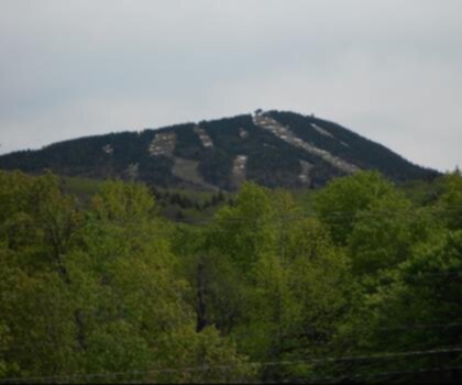
Mendon Peak is one of those summits in Vermont's Green Mountains that doesn't always make the top of the list — and that's exactly what makes it worth your time. Tucked away from the more trafficked corridors of the range, this peak offers a genuine backcountry feel without requiring an expedition-level commitment. If you're looking for a hike that rewards effort with solitude and honest Green Mountain character, Mendon Peak delivers.
The Terrain
The Green Mountains are known for their dense hardwood and mixed conifer forests, and the approach to Mendon Peak is no exception. Expect rooted, rocky trail surfaces typical of Vermont hiking — the kind of terrain that keeps you paying attention to your footing rather than drifting into autopilot. The forest canopy is thick through most of the route, which means shade on warm days but also a slower-drying trail after rain. Mud season in Vermont is real, and Mendon Peak is not immune to it.
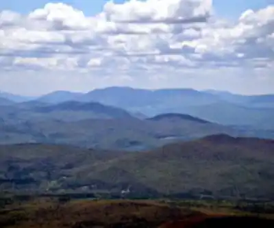
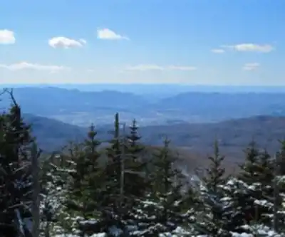
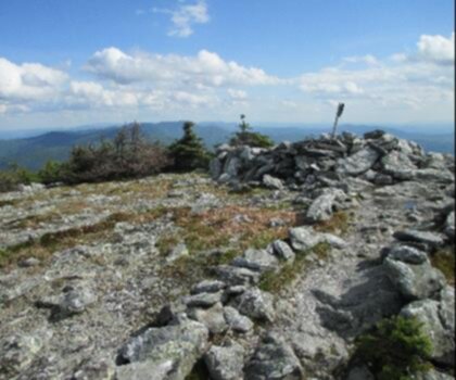
As you gain elevation, the tree composition shifts and the trail opens up in places, giving you a better sense of the ridge structure that defines this part of the Green Mountains. The upper sections tend to be steeper and more rugged, with exposed rock and roots that demand a bit more from your legs and your balance.
What to Expect on the Trail
This is not a heavily signed or heavily maintained trail system. Come prepared with a downloaded map or a reliable GPS track — don't count on frequent blazes or trail markers to guide every decision. That said, the route to Mendon Peak is a legitimate hiking experience, not a bushwhack. Hikers with solid basic navigation skills and appropriate footwear will be fine.
The summit itself sits within the broader Green Mountain landscape, and the views depend heavily on conditions and the specific vantage points you reach along the way. Vermont summits at this elevation often offer partial views through the trees rather than wide-open panoramas — but the forest itself, especially in fall, is a destination in its own right.
Gear and Preparation
Vermont weather in the mountains can shift quickly regardless of the season. Even on a clear day in the valley, conditions on the upper slopes of Mendon Peak can be cooler and windier than expected. A few things worth having in your pack:
- Waterproof footwear or gaiters — trail surfaces stay wet long after rain, and stream crossings may be involved depending on the route
- Layers — temperatures drop with elevation, and wind exposure increases near the summit
- Navigation tools — a downloaded offline map and a compass are strongly recommended given the trail's lower traffic and signage
- Plenty of water — there are natural water sources in the Green Mountains, but always treat before drinking
- Trekking poles — useful on the steeper, rockier sections, especially on the descent
Seasonal Considerations
Summer and fall are the most popular windows for hiking Mendon Peak. Fall in particular is exceptional in this part of Vermont — the foliage in the Green Mountains is among the best in New England, and a hike to Mendon Peak during peak color puts you right in the middle of it rather than watching from a roadside pullout.
Spring hiking here means mud. Vermont's mud season typically runs from late March through May, and trails like this one — with their clay-heavy soils and north-facing sections — take longer to firm up. Hiking during this period causes real trail damage, so it's worth waiting until conditions improve.
Winter access is possible for those with snowshoes or microspikes and the experience to handle backcountry winter conditions. The Green Mountains receive significant snowfall, and the upper sections of Mendon Peak can be icy and demanding in cold months.
Access and Parking
Mendon Peak is located in the Green Mountains of Vermont, in the town of Mendon. Access details and trailhead parking specifics are worth confirming before you go — trailhead infrastructure in this area is minimal, and road conditions to the starting point can vary by season. Checking with the Green Mountain National Forest or local trail resources before your visit is a good habit for any hike in this corridor.
Who This Hike Is For
Mendon Peak is best suited for hikers who are comfortable on uneven, rooted terrain and who don't need a heavily developed trail experience to have a good day out. If you're newer to hiking, this isn't the ideal starting point — there are more accessible options in the region with better signage and more forgiving surfaces. But if you've got a few Vermont hikes under your belt and you're looking for something a little off the beaten path, Mendon Peak fits that bill well.
It's also a solid option for hikers who want to explore the Green Mountains without dealing with the crowds that gather on more famous summits in the range. The relative obscurity of Mendon Peak is a genuine asset — you're more likely to share the trail with a handful of locals than with a parade of out-of-state visitors.
Leave No Trace
The Green Mountains are a shared resource, and lower-traffic trails like the one leading to Mendon Peak are particularly sensitive to impact. Stay on the established trail, pack out everything you bring in, and avoid cutting switchbacks — especially when the ground is soft. If you're bringing a dog, keep them leashed and clean up after them. These small habits add up and keep trails like this one worth coming back to.
Recommended gear for this trail


Ready to go?
Everything you need to know before you goStarting Point
To access the hiking trails, you can start from one of the following trailheads:
Bucklin Trailhead: Located on Wheelerville Road, Mendon, VT 05701. This is a popular starting point with a parking area available.
Brewer's Corner Trailhead: Situated at the intersection of Wheelerville Road and Notch Road in Mendon, VT. Parking is limited, so plan accordingly.
Ensure to check local maps and resources for any updates or changes in trailhead accessibility before your visit.
When?
How much?
- Hiking shoes Essential
- → Salomon Elixir Tour Mid WP · 203.38 $
- Layered clothing Essential
- Rain jacket Essential
- Trekking poles
- → Black Diamond Trail Ergo Cork · 69.99 $
- Headlamp
- → Petzl Actik Core 625 · 103.95 $
FAQ - Frequently asked questions
Everything you need to knowThe Essential Hiking Checklist
Everything you need for your next hike. Bilingual, printable, 1 page.
Download the free checklistSimilar hikes nearby
Discover other trails you might enjoy
Mount Abraham, Vermont
Green Mountains
Snowdon Peak, Vermont
Green Mountains

Slate Valley Trails
Green Mountains
Flatlander Farm
Green Mountains
Bristol Tripadvisor #1, Vermont Bed and Breakfast at Russell Young Farm
Green Mountains
Deer Leap Trail
Green Mountains
Hiking near Montpelier
0 trails to explore ~77 km away
We work hard to provide the most up-to-date and error-free data possible. If something seems incorrect, let us know! Your contribution helps the whole community.
Hikers' opinions