

Ready to explore Mount Grant, Vermont? Here's everything you need to know before you go!
Discover the trail
Oh no! We don't have any photos 😢
This trail hasn't been captured yet. Be the first to share your adventure!Trail description
Description
Mount Grant sits quietly in the Green Mountains of Vermont, one of those summits that doesn't always make the highlight reel but rewards the hikers who seek it out. It's a genuine wilderness climb — no crowds, no paved paths, no hand-holding. Just forest, ridge, and the kind of effort that makes reaching the top feel earned.
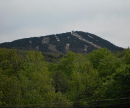
The Mountain and Its Setting
Mount Grant is part of Vermont's Green Mountain range, the long spine of forested ridgeline that runs north to south through the heart of the state. The Green Mountains are known for their dense hardwood and boreal forest cover, their mossy, root-tangled trails, and the way the terrain shifts as you gain elevation — from open hardwood canopy to tighter spruce-fir growth near the upper reaches. Mount Grant fits that profile well. The approach and climb take you through classic Vermont backcountry: quiet, green, and genuinely wild.
This isn't a mountain with a dramatic cliff face or a famous overlook plastered across every hiking blog. What it offers is something a bit rarer in the northeast — a sense of solitude and a trail experience that feels authentic to the region's character.
The Climb
The route up Mount Grant is a proper climb in the Vermont tradition. Expect rooted, rocky trail underfoot, with the grade steepening as you work your way toward the summit. The forest is the main companion here — tall trees, filtered light, and the occasional sound of wind moving through the canopy above. The trail demands attention; loose rocks and exposed roots are part of the deal, especially after rain.
Vermont trails have a reputation for being more rugged than their modest elevations might suggest, and Mount Grant is no exception. The terrain keeps you engaged the whole way up. Footing matters, and trekking poles are a smart call, particularly on the descent when tired legs meet slippery rock.
The upper section of the climb tightens into the kind of dense conifer growth typical of Green Mountain summits — spruce and fir closing in, the air cooler and sharper, the ground softer underfoot with accumulated duff and moss. It's a noticeable transition that signals you're getting close.
What to Expect at the Top
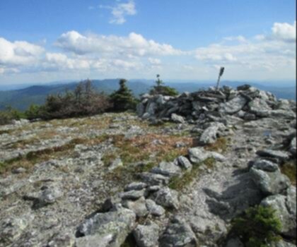
Mount Grant's summit is forested, which is typical for many Green Mountain peaks. Don't come expecting a wide-open panorama — the trees hold their ground up here. What you get instead is the quiet satisfaction of a wooded summit, the kind of place where you sit on a rock, eat your lunch, and actually decompress. For hikers who've grown tired of crowded viewpoints, that's not a downside.
If views are a priority, keep an eye out for any natural openings or ledges along the upper trail — these can offer glimpses into the surrounding ridgeline and valley below, particularly when the leaves are off the trees in early spring or late fall.
Trail Conditions and Terrain
Like most trails in the Green Mountains, Mount Grant's route can be muddy and soft during the spring thaw and after heavy rain. Vermont's "mud season" — roughly mid-March through May — is real, and hiking during this period can cause significant trail damage. The Leave No Trace principle of staying on trail is especially important here; widening around muddy sections compounds erosion quickly on these forest paths.
Summer and fall are the prime seasons. Fall in particular transforms the Green Mountains into something special — the hardwood forest ignites with color, the air is crisp, and the bugs are gone. Early fall weekdays on a trail like Mount Grant can feel like having the whole mountain to yourself.
Winter ascents are possible for those with the right gear and experience. Snowshoes or microspikes are typically necessary once the snow sets in, and the trail can become icy and challenging. The reward is a hushed, snow-covered forest that looks nothing like its summer self.
Getting There
Mount Grant is accessed via the Green Mountains of Vermont. As with many backcountry trailheads in this region, road conditions and parking areas can vary — it's worth checking current trail access information before heading out, particularly in shoulder seasons when dirt roads may be gated or rough. Vermont's Agency of Natural Resources and the Green Mountain Club are reliable sources for up-to-date trail and access information.
Cell service in this area is limited to nonexistent, which is worth knowing before you go. Download offline maps, let someone know your plan, and carry a paper map if you have one.
Who This Hike Is For
Mount Grant suits hikers who are comfortable on rugged, unmaintained-feeling terrain and who don't need a summit view to feel like the day was worth it. It's a good fit for:
- Experienced day hikers looking for a quieter alternative to Vermont's more trafficked peaks
- Hikers bagging Green Mountain summits working through the range systematically
- Anyone who values solitude over amenities — there are no facilities, no signs every hundred meters, no crowds
- Fall foliage seekers who want to be inside the color rather than looking at it from a viewpoint
It's not the right choice for beginners unfamiliar with backcountry navigation, or for anyone expecting a groomed, well-signed trail experience. The Green Mountains reward preparation and self-sufficiency.
Practical Notes
- Footwear: Waterproof hiking boots with ankle support are strongly recommended. Trail runners work for experienced hikers who know the terrain, but the rocky, rooted surface is unforgiving on flat soles.
- Water: Carry all the water you need. Any surface water sources should be treated before drinking.
- Navigation: Bring a map and compass or a downloaded offline GPS track. Trail signage in this area is minimal.
- Weather: Mountain weather in Vermont changes fast. A clear morning can turn wet and cold by afternoon. Pack a rain layer regardless of the forecast.
- Leave No Trace: Pack out everything you bring in. This is a low-traffic area — keep it that way.
Recommended gear for this trail


Ready to go?
Everything you need to know before you goStarting Point
To access the hiking trails, you can start at one of the following trailheads:
Bald Mountain Trailhead: Located on Bald Mountain Road, this is a common starting point for hikers. The parking area is available near the trailhead.
Mount Grant Trailhead: Situated off Route 73, this trailhead provides another entry point to the trails. Look for signage indicating the parking lot.
Both locations offer convenient access to the hiking paths in the area.
When?
How much?
- Hiking shoes Essential
- → Salomon Elixir Tour Mid WP · 203.38 $
- Layered clothing Essential
- Rain jacket Essential
- Trekking poles
- → Black Diamond Trail Ergo Cork · 69.99 $
- Headlamp
- → Petzl Actik Core 625 · 103.95 $
FAQ - Frequently asked questions
Everything you need to knowThe Essential Hiking Checklist
Everything you need for your next hike. Bilingual, printable, 1 page.
Download the free checklistSimilar hikes nearby
Discover other trails you might enjoy
Mount Abraham, Vermont
Green Mountains
Snowdon Peak, Vermont
Green Mountains

Slate Valley Trails
Green Mountains
Flatlander Farm
Green Mountains
Bristol Tripadvisor #1, Vermont Bed and Breakfast at Russell Young Farm
Green Mountains
Deer Leap Trail
Green Mountains
Hiking near Montpelier
0 trails to explore ~36 km away
We work hard to provide the most up-to-date and error-free data possible. If something seems incorrect, let us know! Your contribution helps the whole community.
Hikers' opinions