

Ready to explore Pico Peak, Vermont? Here's everything you need to know before you go!
Discover the trail
Trail description
Description
Pico Peak is one of those Vermont summits that earns its reputation the honest way — through a genuine climb, real elevation gain, and a payoff that feels proportional to the effort you put in. Located in the Green Mountains of Vermont, Pico sits just next door to Killington and draws hikers who want a legitimate mountain experience without the resort crowds that tend to dominate the area in ski season. If you're looking for a hike that feels wild and rewarding in equal measure, Pico Peak delivers.
The Mountain and Its Setting
Pico Peak is part of the Green Mountain range, the spine of Vermont that runs north to south through the state. The mountain has a distinct identity separate from its famous neighbor Killington, even though the two share terrain and are connected by ski infrastructure in winter. On foot, though, Pico feels like its own place — quieter, more forested, and with a summit character that rewards those who make the trip specifically for it.
The terrain here is classic New England: dense hardwood and conifer forest on the lower slopes, transitioning to more exposed, rugged ground as you gain elevation. The trail network in this part of the Green Mountains is well-established, and Pico Peak sits within reach of the Long Trail corridor, Vermont's iconic end-to-end footpath that has been drawing hikers for over a century.
What the Hike Is Like
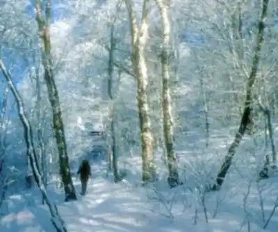
The approach to Pico Peak takes you through forest that shifts noticeably as you climb. Lower sections move through mixed hardwoods — maples, birches, beeches — the kind of canopy that turns spectacular in fall. As you gain elevation, the forest transitions toward spruce and fir, the air gets cooler and more resinous, and the trail underfoot becomes rockier and more demanding.
The climb itself is sustained. This isn't a gradual walk-up — Pico asks you to work for it, with sections that require attention to footing and a steady pace. That said, the trail is well-traveled enough that route-finding isn't a concern. You're following a clear path with a clear objective: the summit.
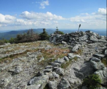
Near the top, the terrain opens up and the views start to reveal themselves. The summit of Pico Peak offers panoramic sightlines across the Green Mountains, with the ridgeline and surrounding peaks filling the horizon. On a clear day, the landscape stretches in multiple directions — a reminder of just how much wild terrain Vermont still holds.
Trailhead and Access
Access to Pico Peak is straightforward for anyone familiar with the Killington area of Vermont. The trailhead is reachable by car, and parking is available in the area. As with most Green Mountain trailheads, arriving earlier in the day is a smart move on weekends and during peak fall foliage season, when the area sees significantly more traffic.
The Green Mountains are managed in part by the Green Mountain National Forest, and the Long Trail — maintained by the Green Mountain Club — passes through this region. Hikers should be aware of Leave No Trace principles and any posted regulations at the trailhead.
Seasons and Conditions
Pico Peak is a genuine four-season mountain, though each season comes with its own considerations:
- Summer is the most straightforward time to hike Pico. Trails are generally dry, the forest is in full leaf, and the climb is enjoyable in the cooler temperatures that come with elevation gain.
- Fall is arguably the most popular season. The foliage in the Green Mountains is world-class, and Pico's elevation means you're above much of the lower canopy, giving you elevated views of the color spread across the valleys and ridges below.
- Winter turns Pico into a snowshoe or microspike objective. The mountain receives significant snowfall, and the upper slopes can be icy and demanding. Winter hikers should be equipped accordingly and check conditions before heading out.
- Spring (mud season) is the trickiest time. Vermont's mud season is real — trails can be deeply rutted and soft, and hiking during this period causes lasting damage to the trail surface. Many experienced Vermont hikers wait until the trails have dried and firmed up before heading out in spring.
What Makes Pico Peak Worth the Trip
What sets Pico apart from other Green Mountain hikes is the combination of a genuine summit experience and a slightly under-the-radar reputation. Killington draws the big crowds — Pico tends to attract hikers who've done their homework and specifically want this mountain. That means the trail has a different feel: more focused, less congested, and with a summit that feels earned rather than incidental.
The views from the top are legitimately impressive. You're standing on a real peak in a real mountain range, with the kind of sightlines that remind you why people have been hiking in Vermont for generations. The Green Mountains aren't the Rockies — they're older, rounder, more forested — but they have a character and a beauty that's entirely their own, and Pico Peak is one of the better places to experience that.
Practical Tips
- Footwear: Wear proper hiking boots with ankle support. The upper sections of the trail are rocky and uneven, and trail runners are workable but boots are more comfortable on the descent.
- Layers: Summit temperatures on Pico can be significantly cooler than at the trailhead, especially in shoulder seasons. Bring a wind layer at minimum.
- Water: Carry enough water for the full round trip. Don't count on finding reliable water sources on the trail without a filter.
- Timing: Start early if you're hiking on a fall weekend. Trailhead parking fills up, and the summit is most enjoyable before afternoon clouds roll in.
- Trail conditions: Check current conditions through the Green Mountain Club or local Vermont hiking resources before your trip, particularly in spring and after significant weather events.
Pico Peak is the kind of hike that sticks with you — a real Vermont mountain, a real climb, and a summit that gives you exactly what you came for.
Recommended gear for this trail


Ready to go?
Everything you need to know before you goStarting Point
To access the hiking trails, you can start at one of the following trailheads:
Sherburne Pass Trailhead: Located on U.S. Route 4, approximately 5 miles east of Killington, VT. There is a parking area available near the Inn at Long Trail.
Pico Mountain Resort Base Area: Situated at 4763 Killington Road, Killington, VT 05751. Parking is available at the resort's base area lot.
Both locations provide access to different routes leading to the summit.
When?
How much?
- Hiking shoes Essential
- → Salomon Elixir Tour Mid WP · 203.38 $
- Layered clothing Essential
- Rain jacket Essential
- Trekking poles
- → Black Diamond Trail Ergo Cork · 69.99 $
- Headlamp
- → Petzl Actik Core 625 · 103.95 $
FAQ - Frequently asked questions
Everything you need to knowThe Essential Hiking Checklist
Everything you need for your next hike. Bilingual, printable, 1 page.
Download the free checklistSimilar hikes nearby
Discover other trails you might enjoy
Mount Abraham, Vermont
Green Mountains
Snowdon Peak, Vermont
Green Mountains

Slate Valley Trails
Green Mountains
Flatlander Farm
Green Mountains
Bristol Tripadvisor #1, Vermont Bed and Breakfast at Russell Young Farm
Green Mountains
Deer Leap Trail
Green Mountains
Hiking near Montpelier
0 trails to explore ~72 km away
We work hard to provide the most up-to-date and error-free data possible. If something seems incorrect, let us know! Your contribution helps the whole community.
Hikers' opinions