

Ready to explore Shrewsbury Peak, Vermont? Here's everything you need to know before you go!
Discover the trail
Trail description
Description
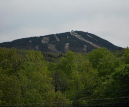
Shrewsbury Peak is one of those Vermont summits that rewards hikers with a genuine sense of accomplishment without demanding a full-day commitment. Tucked into the Green Mountains of central Vermont, this trail leads through classic northern hardwood and boreal forest before breaking out near the rocky summit — a satisfying payoff that keeps people coming back season after season.
The Trail Experience
The hike to Shrewsbury Peak follows a well-established route that climbs steadily through the forest. The trail surface transitions as you gain elevation — from packed dirt and roots in the lower sections to rockier, more rugged terrain as you approach the top. It's the kind of hike where you're always moving upward, but the grade stays manageable enough that you can actually enjoy the surroundings instead of just staring at your feet.
The forest itself is worth paying attention to. Lower down, you'll walk through a mix of hardwoods — maple, beech, yellow birch — that put on a spectacular show in fall. As the trail climbs, the canopy shifts toward spruce and fir, and the air takes on that sharp, resinous smell that's distinctly Vermont high country. The transition between these two forest types is gradual but noticeable, and it's one of the things that makes this trail feel like more than just a climb to a viewpoint.
The Summit
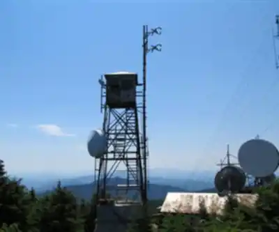
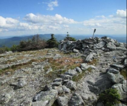
Near the top, the trees thin out and the terrain opens up. The summit area of Shrewsbury Peak offers views that stretch across the surrounding Green Mountain landscape — ridgelines, forested valleys, and the kind of wide Vermont sky that makes you glad you made the effort. It's not a bare, exposed alpine summit, but there's enough open rock to find a good spot to sit, eat lunch, and take in the scenery without feeling crowded.
There's a fire warden's cabin near the summit — a historic structure that adds a bit of character to the destination and serves as a tangible reminder of Vermont's long history of forest management and fire lookout culture. It's worth pausing here to appreciate both the view and the history embedded in the landscape.
What to Expect on the Ground
The trail is part of the network managed within the Green Mountain National Forest, which means it's generally well-maintained and marked. That said, like most Vermont mountain trails, it can be muddy during spring mud season and after heavy rain — waterproof footwear is a smart call for most of the hiking season. The rocky sections near the summit can also be slippery when wet, so trekking poles are useful if you're not already in the habit of using them.
The trailhead is accessible by car, with parking available at the start. It's a relatively quiet trailhead compared to some of the more heavily trafficked Green Mountain destinations, which means you're less likely to deal with a packed parking lot on a busy weekend — though arriving early is always a good idea during peak fall foliage season.
Flora and Wildlife
The forest along the Shrewsbury Peak trail supports the kind of biodiversity you'd expect from a healthy Green Mountain ecosystem. The hardwood zone lower on the trail is good habitat for woodland birds, and the boreal upper section is worth scanning for species like Blackpoll Warbler and Bicknell's Thrush — the latter being a species closely associated with high-elevation spruce-fir forests in the Northeast. Wildflowers appear along the trail in late spring and early summer, particularly in the more open sections and along any wet areas near the base.
White-tailed deer, black bear, and moose all inhabit this part of Vermont, though you're most likely to see signs of their presence — tracks, scat, browse marks — rather than the animals themselves during a daytime hike.
Seasonal Considerations
Shrewsbury Peak is a four-season destination, though each season comes with its own conditions to plan around:
- Spring: Mud season in Vermont is real. Trails can be deeply rutted and saturated from late March through May. If you hike during this period, stick to the edges of the trail to minimize erosion damage.
- Summer: The most straightforward time to hike. The forest canopy keeps the lower trail cool, and the summit views are clear on good days.
- Fall: Peak foliage typically hits central Vermont in early to mid-October. The views from the summit take on a completely different character when the hardwood forest below is lit up in red, orange, and yellow.
- Winter: Snowshoeing and ski touring are possible on this trail in winter. Conditions vary significantly — check recent trail reports before heading out, and be prepared for icy sections near the summit.
Practical Information
- Location: Shrewsbury Peak is located in Shrewsbury, Vermont, within the Green Mountain National Forest.
- Trailhead access: The trailhead is reached via CCC Road off Route 103. The road can be rough in spots — a vehicle with reasonable clearance is helpful, especially early in the season.
- Dogs: Dogs are generally welcome on Green Mountain National Forest trails. Keep them under control and clean up after them.
- Leave No Trace: Pack out everything you bring in. The summit area and the historic cabin deserve to stay in good shape for everyone who follows.
- Cell service: Don't count on reliable cell coverage on the trail. Download offline maps before you go.
Who This Hike Is Good For
Shrewsbury Peak works well for hikers who want a genuine mountain experience — real elevation gain, a forest that changes as you climb, and a summit worth reaching — without committing to an all-day epic. It's a solid choice for fit beginners looking to push themselves, and equally satisfying for experienced hikers who want a good workout on a weekday or a low-key outing when the bigger peaks are socked in with clouds. The historic cabin at the top gives families and curious hikers an extra point of interest beyond the view itself.
Recommended gear for this trail


Ready to go?
Everything you need to know before you goStarting Point
To access the hiking trails, you can start at one of the following trailheads:
Shrewsbury Peak Trailhead: Located on CCC Road, accessible from Route 103. Follow CCC Road for approximately 3 miles to reach the parking area.
Bowman Road Trailhead: From Route 103, take Upper Cold River Road and then turn onto Bowman Road. Continue until you reach the designated parking area near the trailhead.
Both trailheads provide access to different routes leading to your destination.
When?
How much?
- Hiking shoes Essential
- → Salomon Elixir Tour Mid WP · 203.38 $
- Layered clothing Essential
- Rain jacket Essential
- Trekking poles
- → Black Diamond Trail Ergo Cork · 69.99 $
- Headlamp
- → Petzl Actik Core 625 · 103.95 $
FAQ - Frequently asked questions
Everything you need to knowThe Essential Hiking Checklist
Everything you need for your next hike. Bilingual, printable, 1 page.
Download the free checklistSimilar hikes nearby
Discover other trails you might enjoy
Mount Abraham, Vermont
Green Mountains
Snowdon Peak, Vermont
Green Mountains

Slate Valley Trails
Green Mountains
Flatlander Farm
Green Mountains
Bristol Tripadvisor #1, Vermont Bed and Breakfast at Russell Young Farm
Green Mountains
Deer Leap Trail
Green Mountains
Hiking near Montpelier
0 trails to explore ~78 km away
We work hard to provide the most up-to-date and error-free data possible. If something seems incorrect, let us know! Your contribution helps the whole community.
Hikers' opinions