

Ready to explore Woodlawn Mountain, Vermont? Here's everything you need to know before you go!
Discover the trail
Oh no! We don't have any photos 😢
This trail hasn't been captured yet. Be the first to share your adventure!Trail description
Description
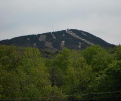
Woodlawn Mountain sits quietly in the Green Mountains of Vermont, the kind of place that rewards hikers who prefer solitude over crowds. It's not one of Vermont's marquee summits, but that's exactly what makes it worth seeking out. If you're looking for a genuine Green Mountain experience without the weekend traffic you'd find on more popular peaks, Woodlawn Mountain delivers.
The Green Mountain Setting
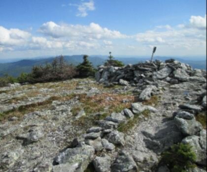
Vermont's Green Mountains are one of the oldest mountain ranges in North America, and hiking here feels different from newer, more dramatic ranges out west. The terrain is rounded and forested, the trails are rooted and mossy, and the landscape has a lived-in quality — shaped by centuries of logging, farming, and regrowth. Woodlawn Mountain fits right into that character. The surrounding forest is classic northern hardwood and boreal mix: sugar maple, yellow birch, beech, and balsam fir as you gain elevation. The understory is dense, the canopy is generous, and in most seasons the trail feels like it's tucked inside the mountain rather than exposed on top of it.
That forest cover is one of the defining features of hiking in this part of Vermont. You're not walking across open ridgelines for miles — you're moving through a living, layered ecosystem that changes as you climb. The light filters differently at different elevations, the air gets noticeably cooler and damper near the summit zone, and the sounds shift from mixed forest birds to the quieter, more sparse soundscape of higher-elevation conifers.
What to Expect on the Trail
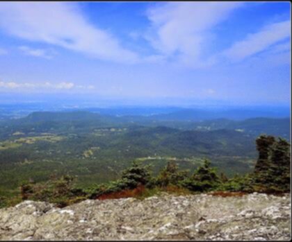
Woodlawn Mountain is the kind of hike where the journey matters more than a dramatic payoff at the top. Vermont summits at this elevation are typically wooded, which means you're hiking for the experience of moving through the terrain rather than chasing a panoramic view. That said, partial openings in the canopy and any rocky outcrops near the top can offer glimpses into the surrounding Green Mountain landscape — the kind of view that feels earned rather than handed to you.
The trail surface you'll encounter is typical of Vermont hiking: expect exposed roots, rocks embedded in the path, and sections that can get muddy after rain or during the spring thaw. Traction and ankle support matter here. Waterproof boots are a smart call for most of the hiking season, and trekking poles help on steeper pitches where the footing gets loose.
Pace yourself on the ascent. Vermont trails in the Green Mountains often look modest on paper but have a way of feeling more sustained than expected once you're on them. The terrain rolls and pitches in ways that keep your legs working consistently, even when the grade doesn't look steep on a map.
Seasons and Timing
Vermont hiking has a rhythm that's worth understanding before you plan your trip. Summer and fall are the prime seasons. Fall in the Green Mountains is genuinely spectacular — the hardwood forest that surrounds Woodlawn Mountain turns in full force, and the combination of color and cool air makes October one of the best months to be on any Vermont trail. Expect company on peak fall weekends, though Woodlawn Mountain will stay quieter than the more famous destinations in the region.
Summer hiking here is pleasant, with the forest canopy keeping temperatures manageable even on warmer days. Bug season peaks in late May and June — black flies are a Vermont reality, and they're worth preparing for with insect repellent and a head net if you're sensitive to them.
Spring hiking in Vermont requires caution. Mud season is real, typically running from late March through May depending on the year. Hiking on soft, saturated trails causes lasting damage to the trail surface, and many Vermont trails ask hikers to stay off until the ground firms up. Check local trail conditions before heading out in spring.
Winter hiking is possible for those with the right gear — microspikes or snowshoes are typically necessary once snow sets in, and the Green Mountains can hold snow well into April at elevation. The forest takes on a completely different character in winter, and the quiet is even more pronounced.
Getting There and Practical Notes
Vermont's Green Mountains are accessible from several directions depending on where you're coming from. The region is served by a network of state and local roads that wind through small towns and rural landscapes — part of the appeal of getting to any trailhead here is the drive itself. Give yourself extra time if you're navigating unfamiliar back roads, especially in fall when leaf-peeper traffic slows things down on the main routes.
Cell service in the Green Mountains is inconsistent. Download your maps offline before leaving your vehicle, and don't count on being able to look things up once you're on the trail. A paper map or downloaded topo is a good backup.
Dress in layers regardless of the season. Vermont mountain weather can shift quickly, and what starts as a warm morning can turn cool and damp by afternoon, especially if clouds move in. A rain layer and an extra mid-layer take up minimal space and can make a real difference in comfort.
Who This Hike Is For
Woodlawn Mountain suits hikers who appreciate a quieter, more immersive forest experience over high-traffic summit destinations. It's a good fit for people who want to explore the Green Mountains beyond the well-worn paths, and for those who find value in the texture of the trail itself — the roots, the rocks, the changing forest — rather than just the destination at the top.
- Forest character: Northern hardwood and boreal mix, with classic Vermont trail conditions underfoot
- Best seasons: Summer and fall; fall foliage in the surrounding hardwood forest is a highlight
- Footwear: Waterproof hiking boots recommended; trekking poles useful on steeper sections
- Navigation: Download maps offline before arriving — cell service is unreliable in the Green Mountains
- Mud season: Avoid spring hiking until trail conditions firm up, typically late May or later depending on the year
- Crowds: Quieter than Vermont's marquee peaks; expect more solitude than on the state's most popular trails
If you're building a Green Mountain itinerary and want to include something off the beaten path, Woodlawn Mountain is worth putting on the list.
Recommended gear for this trail


Ready to go?
Everything you need to know before you goStarting Point
To access the hiking trails, you can start at one of the following trailheads:
Trailhead 1: Located at 123 Mountain Road, Townsville, VT 05601. This is a popular starting point with a parking lot available for hikers.
Trailhead 2: Situated at 456 Forest Lane, Villagetown, VT 05602. There is limited parking here, so arriving early is recommended.
Trailhead 3: Found at 789 Hilltop Avenue, Cityplace, VT 05603. This location offers ample parking and easy access to the trails.
Choose the trailhead that best suits your travel plans and enjoy your hike!
When?
How much?
- Hiking shoes Essential
- → Salomon Elixir Tour Mid WP · 203.38 $
- Layered clothing Essential
- Rain jacket Essential
- Trekking poles
- → Black Diamond Trail Ergo Cork · 69.99 $
- Headlamp
- → Petzl Actik Core 625 · 103.95 $
FAQ - Frequently asked questions
Everything you need to knowThe Essential Hiking Checklist
Everything you need for your next hike. Bilingual, printable, 1 page.
Download the free checklistSimilar hikes nearby
Discover other trails you might enjoy
Mount Abraham, Vermont
Green Mountains
Snowdon Peak, Vermont
Green Mountains

Slate Valley Trails
Green Mountains
Flatlander Farm
Green Mountains
Bristol Tripadvisor #1, Vermont Bed and Breakfast at Russell Young Farm
Green Mountains
Killington Peak
Green Mountains
Hiking near Saratoga Springs
0 trails to explore ~63 km away
We work hard to provide the most up-to-date and error-free data possible. If something seems incorrect, let us know! Your contribution helps the whole community.
Hikers' opinions