

Ready to explore Gore Mountain, Vermont? Here's everything you need to know before you go!
Discover the trail
Oh no! We don't have any photos 😢
This trail hasn't been captured yet. Be the first to share your adventure!Trail description
Description
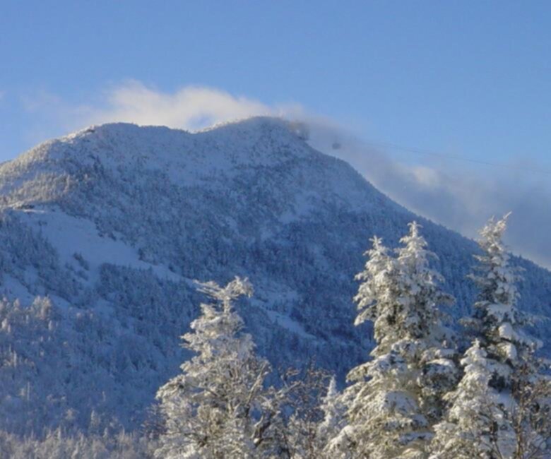
Gore Mountain in Vermont's Northeast Kingdom delivers a satisfying climb through classic Green Mountain terrain, with enough elevation gain and trail variety to keep experienced hikers engaged from start to finish. At 4.8 km with 335 meters of elevation gain, this is a moderate outing that takes most hikers around two and a half hours — long enough to feel like a real mountain day, short enough to leave energy for exploring the region afterward.
The Northeast Kingdom is one of Vermont's least-developed corners, and Gore Mountain reflects that character. The surrounding landscape is dense, quiet, and genuinely wild-feeling — the kind of place where you're more likely to share the trail with a white-tailed deer than another hiking party. That relative solitude is part of what makes this summit worth seeking out.
The Climb
The trail gains elevation steadily rather than brutally, which puts it squarely in moderate territory. You're not scrambling up exposed ledges, but you're also not strolling — the 335-meter gain over 4.8 km means you'll feel the work in your legs, especially in the upper sections where the grade tends to steepen before the summit opens up. Rocky terrain and exposed roots are part of the picture, so footwear with solid ankle support and grip makes a real difference, particularly after rain.
The forest cover shifts as you climb. Lower sections move through mixed hardwood — maple, beech, yellow birch — while higher elevations transition toward conifers, with the air taking on that cooler, resinous quality that signals you're getting somewhere. These ecological transitions happen gradually, but paying attention to them gives the hike a sense of progression beyond just the physical effort.
The Summit
The payoff at the top is the kind of panoramic view that defines Northeast Kingdom hiking. Vermont's characteristic landscape spreads out in every direction — forested ridgelines, rolling terrain, and the open sky that you've earned through the climb. The summit is a natural spot to stop, eat, and take your time before heading back down. Early morning starts tend to reward hikers with cleaner light and clearer air, though the views hold up well through most of the day in fair weather.
Wildlife and Forest
Gore Mountain sits within a healthy Vermont forest ecosystem, and wildlife sightings are a genuine part of the experience rather than a lucky bonus. White-tailed deer are frequently spotted, especially during early morning and late afternoon hours when they move more freely through the trees. The bird life in Vermont's mixed forests is diverse, and the varied habitat along the elevation gradient — from deciduous understory to coniferous canopy — means you're moving through different communities of species as you ascend. Binoculars are worth the extra weight if birding is part of your interest.
Trail Conditions and What to Expect
The trail is well-marked, which keeps navigation simple and lets you focus on the terrain rather than route-finding. The surface varies between packed earth, root networks, and rockier ground in the upper sections. Wet conditions make the roots and rocks noticeably slippery, so checking the forecast before you go is worth the two minutes it takes. Spring can bring soft, muddy sections as snowmelt works through the soil, while fall offers the most visually dramatic conditions — the Northeast Kingdom's hardwood forests put on a serious show in late September and early October.
Planning Your Visit
The 2h30 estimated duration makes Gore Mountain a realistic half-day outing, leaving plenty of time to explore the broader Northeast Kingdom before or after. Starting early gives you the summit in good light and gets you ahead of any afternoon weather that can build over Vermont's hills in summer. Bring enough water for the full round trip — there are no reliable water sources on the trail itself — along with snacks and layers, since summit temperatures run cooler than the trailhead even on warm days.
The Northeast Kingdom's network of hiking opportunities means Gore Mountain pairs well with other trails in the region if you're spending multiple days in the area. It works equally well as a standalone day trip for anyone driving up from elsewhere in Vermont.
Best Seasons
Gore Mountain is hikeable from late spring through late fall under normal conditions. Summer offers the most straightforward experience, with dry trails and long daylight hours. Fall is the most popular season for obvious reasons — the foliage in this part of Vermont is exceptional, and the cooler temperatures make the climb more comfortable. Spring hiking is possible but expect muddy conditions and check trail status before heading out. Winter hiking on this route requires appropriate gear and experience with snow-covered terrain.
Recommended gear for this trail


Ready to go?
Everything you need to know before you goStarting Point
To access the hiking trails, head to the primary trailhead located at 793 Peaceful Valley Road, North Creek, NY 12853. If you're looking for alternative starting points, you can also begin your hike from the trailhead at 793 Peaceful Valley Road, North Creek, NY 12853.
When?
How much?
- Hiking shoes Essential
- → Salomon Elixir Tour Mid WP · 203.38 $
- Layered clothing Essential
- Rain jacket Essential
- Trekking poles
- → Black Diamond Trail Ergo Cork · 69.99 $
- Headlamp
- → Petzl Actik Core 625 · 103.95 $
FAQ - Frequently asked questions
Everything you need to knowThe Essential Hiking Checklist
Everything you need for your next hike. Bilingual, printable, 1 page.
Download the free checklistSimilar hikes nearby
Discover other trails you might enjoy

Echo Lake Trail
Northeast Kingdom
Lake Willoughby
Northeast Kingdom
Bluff mountain hiking trail head
Northeast Kingdom
Owls Head Mt.
Northeast Kingdom
Willoughby State Forest
Northeast Kingdom
Jay Peak
Northeast Kingdom
Hiking near Sherbrooke
53 trails to explore ~54 km away
We work hard to provide the most up-to-date and error-free data possible. If something seems incorrect, let us know! Your contribution helps the whole community.
Hikers' opinions