
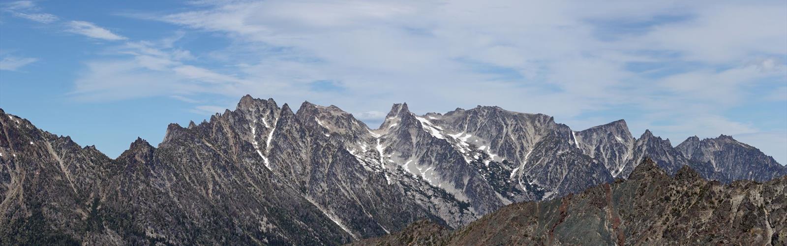

Ready to explore Mount Stuart? Here's everything you need to know before you go!
Discover the trail
Trail description
Mount Stuart is one of the most iconic and demanding destinations in Washington State's Cascade Range. Rising as the second-highest non-volcanic peak in the state, it draws experienced mountaineers and ambitious hikers from across the Pacific Northwest and beyond. The mountain sits within the Alpine Lakes Wilderness, a protected landscape defined by rugged granite, high alpine meadows, and a network of glacially carved lakes. If you're looking for a genuine wilderness challenge in Washington, Mount Stuart delivers on every level.
The Terrain
Mount Stuart's character is defined by its massive granite bulk. The approach trails wind through dense subalpine forest before opening onto exposed ridgelines and boulder fields. The upper mountain is technical in nature — loose rock, steep scrambles, and route-finding challenges are part of the experience. The landscape shifts dramatically as you gain elevation, moving from forested valley floors through open meadows and eventually onto the raw, wind-scoured granite that makes up the summit pyramid.
The surrounding Alpine Lakes Wilderness adds to the appeal. The area is dotted with pristine alpine lakes, many of them accessible as part of longer loop routes or as destinations in their own right. Ingalls Lake, situated below the peak's southern flanks, is one of the most photographed spots in the entire wilderness — the reflection of Stuart's granite walls in the lake's clear water is a classic Washington image.
What to Expect on the Trail
There are several routes to the summit and into the surrounding terrain, ranging from strenuous day hikes to multi-day mountaineering objectives. The most popular non-technical approach follows the Ingalls Way trail, which brings hikers into the Ingalls Creek drainage and up toward Ingalls Pass before reaching Ingalls Lake. From there, the view of Mount Stuart's north face is dramatic and fully earned.
For those aiming for the true summit, the West Ridge route is the standard non-technical line, though it still involves significant scrambling on Class 3 terrain and requires solid route-finding skills. The summit push is long and physically demanding — expect a full day with an early start. Parties attempting the summit should be comfortable on exposed rock and prepared for rapidly changing mountain weather.
The trail conditions vary significantly by season. Snow lingers well into summer at higher elevations, and the window for safe, snow-free travel to the summit is typically mid-summer through early fall. Early season attempts require ice axe and crampon skills. Always check current conditions before heading out.
The Alpine Lakes Wilderness Context
Mount Stuart sits within the Alpine Lakes Wilderness, which is managed jointly by the Okanogan-Wenatchee National Forest and the Mount Baker-Snoqualmie National Forest. This designation means the area is subject to wilderness regulations — no motorized or mechanized equipment, Leave No Trace principles apply strictly, and group size limits are enforced. Permits are required for overnight stays in the Enchantments and surrounding zones during peak season, so check current permit requirements well in advance if you're planning a multi-day trip.
The wilderness designation also means the trails are maintained to a minimal standard in many areas. Some routes are more use-trail than maintained path, and navigation skills are genuinely useful here. A topographic map and compass — or a downloaded offline GPS track — are worth having.
Wildlife and Natural Features
The Alpine Lakes Wilderness around Mount Stuart supports a healthy range of wildlife. Mountain goats are frequently spotted on the upper rocky terrain — they're well adapted to the same granite ledges that challenge human climbers. Marmots are common in the boulder fields and meadows, and their alarm calls are a reliable soundtrack on summer days. Pikas inhabit the talus slopes at higher elevations. Raptors, including golden eagles, are occasionally spotted riding thermals above the ridgelines.
The granite geology of Mount Stuart is notable even by Cascade standards. The Stuart Batholith — the intrusive igneous rock mass that forms the mountain — is one of the largest exposed granite bodies in the range. The rock quality is generally good for climbing, which is part of why Mount Stuart has become a destination for technical climbers pursuing longer alpine routes on the north and east faces.
Practical Information
Access to the Mount Stuart area typically comes via the Teanaway River Road corridor, with trailheads serving different approach routes. A Northwest Forest Pass or equivalent federal recreation pass is required for parking at most trailheads in the area. Arrive early during peak summer weekends — trailhead parking fills up quickly, and the approach roads can be congested.
Cell service is limited to nonexistent once you're in the drainage. Let someone know your itinerary before you go. Water sources are available along most approach routes, but all water should be treated before drinking.
- Wilderness permits: Required for overnight stays in designated zones — check with the Okanogan-Wenatchee National Forest for current requirements
- Parking pass: Northwest Forest Pass or America the Beautiful pass required at most trailheads
- Dogs: Permitted on leash in the wilderness area — check specific trailhead regulations
- Best season: Mid-summer through early fall for snow-free conditions at higher elevations
- Navigation: Topo map and GPS recommended — upper routes involve route-finding on unmarked terrain
- Summit routes: West Ridge is the standard non-technical line but involves Class 3 scrambling on exposed rock
Who This Mountain Is For
Mount Stuart is not a beginner destination. The approach hikes into the surrounding terrain are manageable for fit hikers with solid trail experience, but the summit routes demand more — physical endurance, comfort on exposed scrambling terrain, and the judgment to turn around when conditions aren't right. That said, you don't need to summit to have a worthwhile day here. The trail to Ingalls Lake alone is a full and rewarding outing, and the views of Mount Stuart from the lake basin are as good as anything in the Washington Cascades.
If you're building toward bigger objectives in the range, spending time in the Stuart zone is excellent preparation — the terrain is varied, the navigation challenges are real, and the mountain has a way of making you earn every foot of elevation you gain.
The Essential Hiking Checklist
Everything you need for your next hike. Bilingual, printable, 1 page.
Get your free hiking checklistRecommended gear for this trail
As an Amazon Associate I earn from qualifying purchases.


Ready to go?
Everything you need to know before you goWhen?
How much?
As an Amazon Associate I earn from qualifying purchases.
Affiliate links — LGPO may earn a commission at no extra cost to you.
- Hiking shoes Essential
- → Salomon Elixir Tour Mid WP · 203.38 $
- Layered clothing Essential
- Rain jacket Essential
- Trekking poles
- → Black Diamond Trail Ergo Cork · 69.99 $
- Headlamp
- → Petzl Actik Core 625 · 103.95 $
FAQ - Frequently asked questions
Everything you need to knowHiking near Victoria
93 trails to explore ~215 km away
We work hard to provide the most up-to-date and error-free data possible. If something seems incorrect, let us know! Your contribution helps the whole community.
Hikers' opinions
Be the first to review!
No hiker has shared their experience yet. Share your impressions and help other hikers!